Download
1 / 30
460 likes | 919 Views
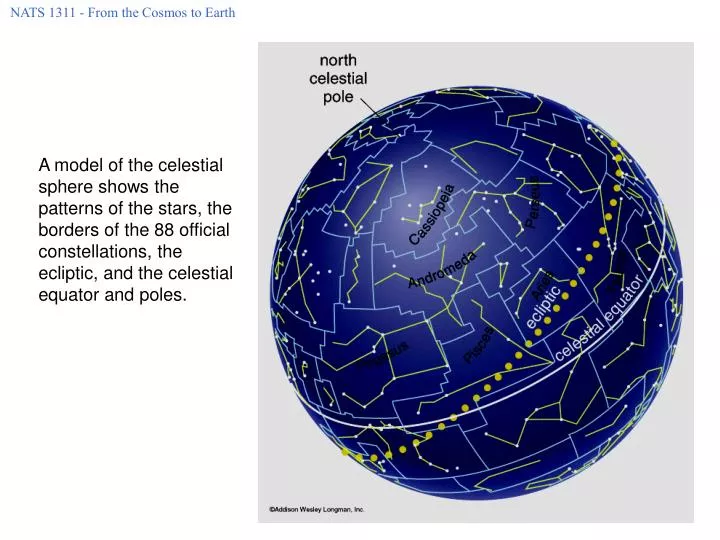
A model of the celestial sphere shows the patterns of the stars, the borders of the 88 official constellations, the ecliptic, and the celestial equator and poles. Latitude and Longitude.

E N D
NATS 1311 - From the Cosmos to Earth A model of the celestial sphere shows the patterns of the stars, the borders of the 88 official constellations, the ecliptic, and the celestial equator and poles.
NATS 1311 - From the Cosmos to Earth Latitude and Longitude Latitude - lines of latitude parallel to Earth’s equator - labeled north or south relative to equator - from 90º N to 90º S Longitude - lines of longitude extend from North Pole to South Pole - by international treaty, longitude 0 (the prime meridian) runs through Greenwich, England Dallas: latitude = 32.78º N longitude = 96.78º W
NATS 1311 - From the Cosmos to Earth A circumpolar constellation never rises or sets - they are always visible. Your latitude determines the portion of the celestial sphere visible in your sky. (a) A Northern Hemisphere sky. (b) A Southern Hemisphere sky. At what latitude would you see the entire sky?
NATS 1311 - From the Cosmos to Earth Star Trails The Southern Hemisphere The Northern Hemisphere The Earth's rotation causes stars to trace daily circles around the sky. The north celestial pole lies at the center of the circles. Over the course of a full day, circumpolar stars trace complete circles, and stars that rise in the east and set in the west trace partial circles. Here, the time exposure lasted about 6 hours - we see only about one-quarter of each portion of the full daily path.
NATS 1311 - From the Cosmos to Earth Finding the Celestial Poles You can always find north using the North Star. Polaris can be found using the big dipper. Draw a line through the two “pointer” stars at the end of the big dipper and follow it upwards from the dipper about four outstretched hand’s width. The big dipper is circumpolar in the US so is always above the horizon. The south celestial pole can be found using the Southern Cross. There is no “South Star”
NATS 1311 - From the Cosmos to Earth The Big and Little Dippers
NATS 1311 - From the Cosmos to Earth Motion of the Night Sky Animation
NATS 1311 - From the Cosmos to Earth The height in degrees of the north star above the horizon is the same as your latitude.
NATS 1311 - From the Cosmos to Earth The angle between the horizon and Polaris is the latitude of the observer. If Dallas is at 33º latitude, where is Polaris in the sky? Where is it at the Equator?
NATS 1311 - From the Cosmos to Earth Angular Size Distances in the sky measured by angular distance: Minute of arc = 1/60th of a degree Second of arc = 1/3600th of a degree Angular diameter - angular distance from one side of an object to the other
NATS 1311 - From the Cosmos to Earth Revolution Earth travels around the sun (orbits) once per year in the same direction it rotates. It’s orbit is not quite a perfect circle - it is elliptical. The location in the orbit of the minimum and maximum distances from the Sun are called perihelion and aphelion. The plane of the orbit is called the ecliptic.
NATS 1311 - From the Cosmos to Earth Earth’s Axial Tilt Ecliptic Plane The Earth’s axis is currently tilted 23.5º to the ecliptic. It varies over time between 22º and 25º due the the gravitational forces from Jupiter and the other planets.
NATS 1311 - From the Cosmos to Earth The axis remains at the same tilt angle - pointed at Polaris - throughout the orbit because of conservation of angular momentum. The ecliptic plane is the plane of the Earth’s orbit. Looking from the Earth, it is the apparent path of the Sun (and planets) in the sky.
NATS 1311 - From the Cosmos to Earth The Relationship of the Celestial Equator and the Ecliptic Plane
NATS 1311 - From the Cosmos to Earth The Zodiac The Sun appears to move steadily eastward along the ecliptic, through the constellations of the zodiac. As Earth orbits the Sun, we see the Sun against the background of different zodiac constellations at different times of year. For example, on August 21 the Sun appears to be in the constellation Leo. Defines astral calendar.
NATS 1311 - From the Cosmos to Earth Sun’s Path Through the Zodiac
NATS 1311 - From the Cosmos to Earth Seasons occur because even though the Earth's axis remains pointed toward Polaris throughout the year, the orientation of the axis relative to the Sun changes as the Earth orbits the Sun. Around the time of the summer solstice, the Northern Hemisphere has summer because it is tipped toward the Sun, and the Southern Hemisphere has winter because it is tipped away from the Sun. The situation is reversed around the time of the winter solstice when the Northern Hemisphere has winter and the Southern Hemisphere has summer. At the equinoxes, both hemispheres receive equal amounts of light.
NATS 1311 - From the Cosmos to Earth Why Does Flux Sunlight Vary Animation
NATS 1311 - From the Cosmos to Earth Antarctica June 21 December 21
NATS 1311 - From the Cosmos to Earth In the summer hemisphere, the sun follows a longer and higher path. The sunlight is more intense - more direct and more concentrated. In the winter hemisphere, the sun follows a shorter and lower path. The sunlight is less direct and less intense. Why are the warmest days one to two months after summer solstice?
NATS 1311 - From the Cosmos to Earth The Relationship of the Celestial Equator and the Ecliptic Plane The solstices are when the celestial equator and the ecliptic have the greatest separation - when the Sun is highest in the sky. The equinoxes are when ecliptic and the celestial equator cross - when the Sun crosses from north/south of the celestial equator to south/north of the equator Northern spring equinox is when the Sun passes from south of the celestial equator to north.
NATS 1311 - From the Cosmos to Earth Why are the seasons more extreme in the Northern hemisphere?
NATS 1311 - From the Cosmos to Earth 1. Most of Earth’s land mass in in the Northern Hemisphere. Water takes longer to heat or cool than soil or rock. The water temperature remains relatively constant, thereby moderating the climate. 2. Earth is slightly farther from the sun during northern summer solsitce - moves slower in its orbit so summer/winter is 2 - 3 days longer/shorter. This effect is more important then the slightly more intense sunlight due to Earth being closer/farther away.
NATS 1311 - From the Cosmos to Earth Five Major Circles of Latitude 1. The Arctic Circle (66.5 degrees N) 2. Tropic of Cancer (23.5 degrees N) 3. The Equator 4. The Tropic Capricorn (23.5 degrees S) 5. The Antarctic Circle (66.5 degrees S) What is special about these latitude circles?
NATS 1311 - From the Cosmos to Earth Five Major Circles of Latitude The Arctic and Antarctic Circles - One day a year the sun shines all day and one day a year it doesn’t shine at all. Tropic of Cancer (Capricorn) - The sun is never directly overhead at higher latitudes.
NATS 1311 - From the Cosmos to Earth Daily Paths of the Sun at Equinoxes and Solstices At the equator At the north pole At the tropic of Cancer At 40º latitude
NATS 1311 - From the Cosmos to Earth Celestial Coordinate System • Equatorial System • Declination - - Angle of a star North or South of the Celestial Equator - Measured in Degrees • Right Ascension - - Measure of Angular Distance of a Star East of the Spring Equinox - Measured in Hours, Minutes, Seconds In this coordinate system the position of a star is specified by the right ascension and the declination. This system is used more than any other by astronomers.
NATS 1311 - From the Cosmos to Earth Coordinate Systems Celestial Geographic Declination - lines of declination parallel to celestial equator - labeled positive or negative relative to celestial equator - from -90º to +90º Right ascension - lines of right ascension run from north celestial pole to south celestial pole - by convention 0 runs through spring equinox - measured in hours, minutes and seconds east of spring equinox - one hour is 15º Latitude - lines of latitude parallel to Earth’s equator - labeled north or south relative to equator - from 90º N to 90º S Longitude - lines of longitude extend from North Pole to South Pole - by international treaty, longitude 0 (the prime meridian) runs through Greenwich, England