Download
1 / 17
170 likes | 313 Views
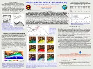
Validation of GCM , and the need of High resolution atmospheric and hydrological model. Vicente Barros and Mariano Re San José de Costa Rica 28 May 2003. Tributarios. Vientos. Onda de marea. Forcings of the Plata River level.

E N D
Validation of GCM, and the need of High resolution atmospheric and hydrological model Vicente Barros and Mariano Re San José de Costa Rica 28 May 2003
Tributarios Vientos Onda de marea Forcings of the Plata River level
Tributaries:-The Plata basin covers 3.2 M. Km²- Runoff depends on Precipitation and evaporation (Temperature)- How good are precipitation and temperature scenarios?
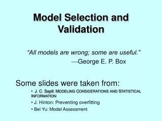
Precipitation Climate minus simulated precipitation scenarios
Validation of climate models: precipitation Difference in annual precipitation between HADCM3 experiment and observed data (mm/day) ~ 30% less than observed
Precipitation features (PFs) for 5 x 5 degree boxes Seasonal distribution of during Dec.1997 to Nov.2000 observed by the TRMM Precipitation Radar (E. Zipser, G. Mota, and S. Nesbitt, 2002)For more details about PF definition see Nesbitt et al., 2000, J. Climate, 13, 4087-4106.
850hPa Circulation Composites - January Warm Events Cold Events
Precipitation is too understimated by GCM: Some physical processes are misrepresented Difficulties with downscaling andPerturbation techniquesHope: CRM models
GCM runned with low resolution • Do not resolve Meso Convective Systems • Do not represent topographycorrectly • Parameterization of convective activity? • Remote ocean forcing? • Frequency and intensity of synoptic perturbations?
SST at Niño 3.4 from HadCm3 SRES A2 experiment SST at Niño 3.4 from GFDL SRES A2 experiment
ETA MODEL EXPERIMENT: Domain and features Workstation ETA Adapted by M. Pyle (NOAA) Horizontal resolution: Grid of 1°lat.X 1°long Vertical: 60 levels Time step: 360 s Running in a System CRAY, Origin 2000. 40 processors Experiment: 10 years with NCEP/NCAR Reanalysis
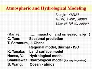
Climate Change 2001:Working Group I: The Scientific Basis Get Javascript Other reports in this collection Table of contentsOther reports in this collection Figure 11.12: Global average sea level rise 1990 to 2100 for the SRES scenarios.
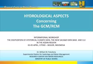
Climate Change 2001:Working Group I: The Scientific Basis Get Javascript Other reports in this collection Table of contentsOther reports in this collection Figure 11.13: Sea level change in metres over the 21st century resulting from thermal expansion and ocean circulation changes calculated from AOGCM experiments following the IS92a scenario
Wind effect on water level is not linear Thus:The mean water level has to be calculated by running the hydrodinamic model forced by instantaneous winds