Download
1 / 13
170 likes | 303 Views
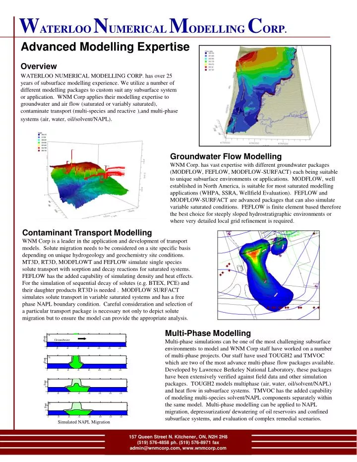
a. Feet. Groundwater Flow. b. Feet. c. Feet. d. Feet. W ATERLOO N UMERICAL M ODELLING C ORP. Advanced Modelling Expertise. Overview

E N D
a. Feet Groundwater Flow b. Feet c. Feet d. Feet WATERLOONUMERICALMODELLINGCORP. Advanced Modelling Expertise Overview WATERLOO NUMERICAL MODELLING CORP. has over 25 years of subsurface modelling experience. We utilize a number of different modelling packages to custom suit any subsurface system or application. WNM Corp applies their modelling expertise to groundwater and air flow (saturated or variably saturated), contaminate transport (multi-species and reactive ),and multi-phase systems (air, water, oil/solvent/NAPL). Groundwater Flow Modelling WNM Corp. has vast expertise with different groundwater packages (MODFLOW, FEFLOW, MODFLOW-SURFACT) each being suitable to unique subsurface environments or applications. MODFLOW, well established in North America, is suitable for most saturated modelling applications (WHPA, SSRA, Wellfield Evaluation). FEFLOW and MODFLOW-SURFACT are advanced packages that can also simulate variable saturated conditions. FEFLOW is finite element based therefore the best choice for steeply sloped hydrostratigraphic environments or where very detailed local grid refinement is required. Contaminant Transport Modelling WNM Corp is a leader in the application and development of transport models. Solute migration needs to be considered on a site specific basis depending on unique hydrogeology and geochemistry site conditions. MT3D, RT3D, MODFLOWT and FEFLOW simulate single species solute transport with sorption and decay reactions for saturated systems. FEFLOW has the added capability of simulating density and heat effects. For the simulation of sequential decay of solutes (e.g. BTEX, PCE) and their daughter products RT3D is needed . MODFLOW SURFACT simulates solute transport in variable saturated systems and has a free phase NAPL boundary condition. Careful consideration and selection of a particular transport package is necessary not only to depict solute migration but to ensure the model can provide the appropriate analysis. Multi-Phase Modelling Multi-phase simulations can be one of the most challenging subsurface environments to model and WNM Corp staff have worked on a number of multi-phase projects. Our staff have used TOUGH2 and TMVOC which are two of the most advance multi-phase flow packages available. Developed by Lawrence Berkeley National Laboratory, these packages have been extensively verified against field data and other simulation packages. TOUGH2 models multiphase (air, water, oil/solvent/NAPL) and heat flow in subsurface systems. TMVOC has the added capability of modeling multi-species solvent/NAPL components separately within the same model. Multi-phase modelling can be applied to NAPL migration, depressurization/ dewatering of oil reservoirs and confined subsurface systems, and evaluation of complex remedial scenarios. Simulated NAPL Migration 157 Queen Street N. Kitchener, ON, N2H 2H8 (519) 576-4858 ph. (519) 576-8971 fax admin@wnmcorp.com, www.wnmcorp.com
WATERLOONUMERICALMODELLINGCORP. Site Environmental Data Management Overview WATERLOO NUMERICAL MODELLING CORP. can assemble, store, and manage your environmental data whether it is water levels, soil concentrations, water quality information, lithologies, or borehole logs. We utilize both commercial packages and custom solutions to provide the right balance for your unique requirements. Cross-sections To understand the subsurface environment and to assist in the generation of an accurate 3-dimensional geologic conceptualizations, interpreted geologic cross-sections are created across the study area. For each cross-section, the geology is displayed from the borehole record followed by interpreting hydrostratigraphic layers. These layers can be used in generating 3D fence diagram and groundwater flow model input. GIS Mapping/Custom Databases The advent of Geographic Information Systems (GIS) has led to a revolutionary way of viewing site environmental data. Using GIS, spatial and temporal trends in the data can easily be visualized on site maps. Customized reports can be automated and are generated based on client needs. Combining a variety of data within the GIS databases allows for quick generation of specialized products such as Aquifer Vulnerability, Aquifer Yield, and Potential Recharge. 157 Queen Street N. Kitchener, ON, N2H 2H8 (519) 576-4858 ph. (519) 576-8971 fax admin@wnmcorp.com, www.wnmcorp.com
WATERLOONUMERICALMODELLINGCORP. Groundwater Resource Assessment Erin, Ontario Overview This study was part of the MOE funded groundwater management studies conducted in 2000-2001. The objective of the project was to delineate wellhead protection areas for the municipal wells in Erin and Hillsburgh and to assess impacts to area streams. MODFLOW and MODPATH were used for the groundwater modelling and wellhead delineation and MT3D was used to model transport processes. Groundwater Flow Modelling The hydrogeologic setting of the study area consists of both an overburden aquifer and bedrock aquifer. The aquifers are recharged mostly through infiltrating precipitation but some recharge comes from the Subwatershed 15 streams and groundwater in-flow from adjacent areas outside Subwatershed 15. Groundwater discharges to the area streams with all discharge eventually flowing to Credit River. Those adjacent areas supplying groundwater to the subwatershed areas are north and northeast of Hillsburgh and south of Hillsburgh and Erin. Project Results Wellhead protection areas and impacts on stream discharge were simulated using several scenarios of future potential development. Aggregate extraction activities were included in these scenarios. The impacts of nitrates resulting from agricultural activities and septic systems on the area streams were also simulated. It was found that the present limited industrial development in the area pose minimum threat to groundwater resources. Septic systems in the area pose little threat to groundwater resources and aquatic environments. Agricultural activities were found to result in elevated nitrate levels in streams. It was found that the area could sustain some future development, but negative impacts to the groundwater resources and area stream are predicted with extensive land development. 157 Queen Street N. Kitchener, ON, N2H 2H8 (519) 576-4858 ph. (519) 576-8971 fax admin@wnmcorp.com, www.wnmcorp.com
WATERLOONUMERICALMODELLINGCORP. Oxford County Groundwater Management Study Overview This study was part of the MOE funded groundwater management studies conducted in 2000-2001. The objective of the project was to delineate wellhead protection areas (WHPA) for the municipal wells in Oxford County. MODFLOW and MODPATH were used for developing the 20 groundwater flow models and over 80 WHPA’s. Groundwater Flow Modelling The hydrogeologic setting of the County was quite varied, ranging from a combination of confined and unconfined systems in either overburden and bedrock. The models that were developed accounted for the lateral and vertical heterogeneties in the overburden layers along with a homogeneous bedrock layer. Project Results The groundwater flow models were used to delineate time of travel (2, 5, 10, and 25 year) WHPA’s for all municipal wells in the county. These WHPA’s from the model were further analyzed in a GIS to account for model uncertainty (hydraulic gradient, and direction of groundwater flow). The WHPA’s were rotated 5 degrees in either direction and then increased in size by 20%. All delineated WHPA’s were delivered to the County of Oxford in their approved ARCVIEW format for incorporation into their official planning documents. The County has implemented planning restraints within the WHPA’s to prevent possible contamination of the municipal wells and subsequent costly remedial measures. 157 Queen Street N. Kitchener, ON, N2H 2H8 (519) 576-4858 ph. (519) 576-8971 fax admin@wnmcorp.com, www.wnmcorp.com
WATERLOONUMERICALMODELLINGCORP. Groundwater Resource Assessment Exeter, Ontario Overview This study was part of the MOE funded groundwater management studies conducted in 2000-2001. The objective of the project was to delineate wellhead protection areas for the municipal wells in Exeter and to assess impacts to area streams. MODFLOW and MODPATH were used for the groundwater modelling and wellhead delineation processes. Groundwater Flow Modelling The regional groundwater system consists of three shallow overburden aquifers separated by aquitards. The aquifer system is recharged through infiltrating precipitation and by streams. Groundwater discharges to the area streams with all discharge eventually flowing to either the Ausable River or Fish Creek. The groundwater has a regional trend of flowing from east to west. Project Results Wellhead protection areas were delineated using present day pumping and future potential pumping. The future scenario included future predicted pumping rates based on potential population growth. All potential contaminant sources were mapped inside the wellhead protection areas. A low permeable till covers most of the area around the well fields giving good protection from surface contamination. All, but one well field, were deemed to be in the influence of streams and ponds. Further studies are being conducted to investigate the issues of the surface water input to the municipal wells, under the “groundwater under direct influence of surface water program”. 157 Queen Street N. Kitchener, ON, N2H 2H8 (519) 576-4858 ph. (519) 576-8971 fax admin@wnmcorp.com, www.wnmcorp.com
GAWSER Recharge (darker colour, higher recharge) WATERLOONUMERICALMODELLINGCORP. Source Water Protection - FEFLOW Model Grand River Watershed Overview The Grand River Conservation Authority is developing regional water budgets for the Grand River watershed (~6800 km2). An important tool in completing the water budget is the FEFLOW groundwater model that was developed by staff at WNM Corp. The Permits to Take Water (PTTW) were analyzed and incorporated into the updated FEFLOW model and water budget analysis. The model output was used in generating components of the regional water budget, a distribution of stream discharge sections, and areas of contribution to discharging river segments (significant recharge features). 3D FEFLOW Groundwater Model The regional FEFLOW model is comprised of 11 hydrostratigraphic layers representing 5 overburden and 6 bedrock layers. The recharge distribution applied in the model was derived from the very detailed GAWSER surface water model developed for the Grand River watershed. The recharge distribution incorporates the effects of the surficial geology, hummocky terrain, precipitation runoff, and evapotranspiration. To assist the GRCA in developing a regional water budget, an analysis of the Permits to Take Water was completed and the best estimate of average annual rates were then incorporated into the FEFLOW model. The PTTW analysis also analyzed the permits on a subwatershed basis to provide the GRCA with an understanding of the distribution of takings throughout the watershed. PTTW Summed by Subwatershed (darker colour, higher takings) Modelling Results The FEFLOW model provided flux values between each of the subwatersheds as well as the amount of water that exits the model via the rivers. These values can be plotted spatially, to provide a map of significant discharge features within the watershed. No only can the model be used for delineating well head capture zones, the model can be used to delineate recharge zones for stretches of rivers and wetlands. River Discharge (blue) / Recharge (red) Recharge zones for Wetlands 157 Queen Street N. Kitchener, ON, N2H 2H8 (519) 576-4858 ph. (519) 576-8971 fax admin@wnmcorp.com, www.wnmcorp.com
WATERLOONUMERICALMODELLINGCORP. Groundwater Resource Assessment County of Huron, Ontario Overview The Huron Groundwater Assessment and Municipal Source Protection Study was undertaken by the County of Huron with financial assistance provided by the MOE. The study is part of the initiative to characterize and protect the groundwater drinking water supplies in Ontario. The overall purpose of the study was to develop an understanding of the regional aquifer characteristics, develop well head protection areas, identify potential threats to the groundwater resource and develop protection strategies. Local Setting The aquifer systems of the study area are mostly bedrock in the north of the County with a mix of both an overburden and bedrock in the south. The bedrock geology is dominated by the Detroit River Group consisting of limestone and dolostone. The overburden dominated by glacial deposits with some area of lacustrine deposits found. The major surface water features of the area are Lake Huron and the Maitland, Bayfield and Ausable Rivers. These bodies, plus a number of smaller streams, were found to be in hydraulic connection with the groundwater systems and therefore were included in water budget calculations, potentiometric surfaces and groundwater modelling. Project Results Based on population estimates, approximately 75% of the population depends on groundwater. Groundwater withdrawal represents about 32% of the total aquifer recharge and is currently well within sustainable levels. Groundwater models were used to develop wellhead protection areas. To delineate wellhead protection areas numerical models were used for high production wells and analytical methods for low production wells. A pilot project consisting of a groundwater management plan was implemented for the community of Hensall. Hensall was chosen because of its long history of water quality issues. The project team organized and worked with community participates to implement the plan components for the Hensall area. 157 Queen Street N. Kitchener, ON, N2H 2H8 (519) 576-4858 ph. (519) 576-8971 fax admin@wnmcorp.com, www.wnmcorp.com
WATERLOONUMERICALMODELLINGCORP. Groundwater Resource Assessment Strathroy, Ontario Overview This study was part of the Ontario Ministry of Environment (MOE) funded groundwater management studies conducted in 2000-2001. The objectives of the project was to delineate wellhead protection areas for Strathroy’s municipal wells and to assess if the municipal wells were under the direct influence of surface water (GUDI). Groundwater Flow Modelling The hydrogeologic setting of the study area consists of a shallow aquifer system that is recharged through infiltrating precipitation and water from the Sydenham and Thames Rivers. Also, the aquifer discharges to smaller streams within the study area, which eventually flow into the Sydenham and Thames Rivers. A groundwater flow model (MODFLOW and MODPATH) was developed that encompassed the town of Strathroy. Wellhead protection areas were delineated using present day pumping and future potential pumping. The future scenario included both future predicted pumping rates from existing well fields and well fields may be developed in the future. Project Results All potential contributors of groundwater contamination were mapped inside the wellhead protection areas. Manure spreading practices were found to be partially responsible for elevated nitrate levels at one well field. The recommended remedial measures included treatment at the well field, well shut-down, purchase of the property by the Town, or incentives for operator to relocate spreading activities. Two well fields were potentially found to be under the direct influence of surface water features requiring additional planning and treatment at those wells. 157 Queen Street N. Kitchener, ON, N2H 2H8 (519) 576-4858 ph. (519) 576-8971 fax admin@wnmcorp.com, www.wnmcorp.com
WATERLOONUMERICALMODELLINGCORP. Assessment of Basal McMurray Watersands for Long-Term Production Requirements Overview The purpose of the study was to assess the Basal McMurray watersands as a viable resource of brackish water for use in light oil recovery operations. The study included the development of oil production forecasts for all operators in the Cold Lake Region and the amount of brackish water required to meet these targets. Utilizing the model, the cumulative effects of long-term brackish water withdrawal were assessed. Top Elevation of the Basal McMurray Aquifer Project Scope The project had three main phases. The first phase involved the completion of a baseline study of the McMurray Formation geologic environment and development of a conceptual hydrogeologic model. The second phase was to construct and calibrate a numerical groundwater model to existing conditions. As part of the calibration process, a detailed sensitivity analysis was completed to quantify the impact of model parameter uncertainty. The third phase of the study utilized the calibrated model for simulating various production forecasts of the Cold Lake operators. LSA Watersands Iospach Project Results The calibrated groundwater flow model proved to be a useful tool in determining that the Basal McMurray aquifer has sufficient resources for the anticipated production forecasts. The model was also used in determining the distribution of withdrawal rates to minimize the overall drawdown in the aquifer. After each model run, the water levels within each of the pumping wells was calculated to prevent scenarios where the pumped heads fell below the top of the aquifer. Another use of the calibrated groundwater flow model was to determine whether alternate well locations had the ability of supplying additional brackish water to the operator. Cut-off trench Extraction Well Model Calculated Heads 157 Queen Street N. Kitchener, ON, N2H 2H8 (519) 576-4858 ph. (519) 576-8971 fax admin@wnmcorp.com, www.wnmcorp.com
a. Groundwater Flow Feet b. Feet c. Feet d. Feet WATERLOONUMERICALMODELLINGCORP. Multiphase and 3-D Numerical Models Dedham County, Massachusetts Overview Leakage of fuel oil into the subsurface from an underground storage tank at the Dedham County Municipal Jail has led to a concern over the possible migration of the fuel oil off-property. A multiphase flow and transport model was developed to investigate the migration pathway and if the municipal well in the area were at risk of becoming contaminated. NAPL Release Groundwater Flow Modelling A comprehensive conceptual model was developed of the area using groundwater, aquifer and surface water data. The boundaries of the conceptual model are defined by natural regional groundwater boundaries that extend far beyond the site limits. Using the conceptual model as a basis, a three-dimensional numerical groundwater model was developed in MODFLOW to simulate groundwater flow. After completion of the groundwater model, MODPATH was used to delineate the capture zones of the municipal wells located northwest of the Site. MOFAT, was used to determine the amount of solute partitioning from the heating oil free product into the water phase. Immobile NAPL Portion Mobil NAPL Portion Simulated NAPL Migration Forward and Reverse Particle Tracking Project Results The modelling results demonstrated that no significant amount of solute was partitioned into the water phase. This was due in part to the fact that the heating oil was comprised mainly of heavy and relatively insoluble carbon chains. The other contributing factor is that the light end chains, that originally existed, have likely volatilized during the 40 year time frame the oil was in the subsurface. The 2nd phase of the study included the development of capture zones for the municipal wells to the northwest. The modelling results indicated that the contaminated site was outside the capture zone of the municipal wells even when model parameter uncertainty was considered. Simulated Longitudinal Travel Of NAPL 157 Queen Street N. Kitchener, ON, N2H 2H8 (519) 576-4858 ph. (519) 576-8971 fax admin@wnmcorp.com, www.wnmcorp.com
WATERLOONUMERICALMODELLINGCORP. Phase II Environmental Assessment Whitecourt, Alberta (Great Rates Motel) Overview As part of the requirement of a property sale, a Phase II Environmental Assessment was completed at a property in Whitecourt, Alberta. There was speculation of subsurface hydrocarbon presence related to documented hydrocarbon releases, which occurred at an adjacent property (a gasoline service station). On the property, a motel operated until 1997 at which time the motel was demolished. There are no records of hydrocarbon releases from operations at the motel. Groundwater and soil samples were collected to determine the level of action required to meet provincial environmental protection guidelines. Site Investigations A detailed site investigation was conducted on July 22, 1999 involving to collection of subsurface materials and the visual inspection of conditions at the site and adjoining property. Nine boreholes were drilled at, and surrounding, the location where the hydrocarbons were reported to have migrated on-site. Groundwater was encountered at approximately 5 feet below ground surface. The subsurface of the site consists of mostly poorly-sorted gravel (commonly known as “pitrun”) with particle sizes ranging from clay to cobble. Water level data collected as part of this study was used to determine that groundwater flow directions at the site coincide with regional groundwater flow directions. Project Results The site was compared to Level II criteria for coarse-grained soils remediation guidelines under Alberta Environmental Protection Guidelines. At the time of sampling, the site met the Level II criteria requiring no further environmental action at that time. Minor hydrocarbon concentrations in the past were the result of activities at the adjacent property (upgrade with respect to surface grade, and upgradient with respect to groundwater flow). The reported concentrations at the site resulted from fuelling overflows at the adjacent service station and a portion of the overflowed fuel migrated on-site by means of overland flow. Historical records show no on-site activities resulted in or, had the likelihood of resulting in, the release of hydrocarbons. 157 Queen Street N. Kitchener, ON, N2H 2H8 (519) 576-4858 ph. (519) 576-8971 fax admin@wnmcorp.com, www.wnmcorp.com
WATERLOONUMERICALMODELLINGCORP. Transport and Phytoremediation of Organic Contaminants Overview This study investigated the transport and migration of contaminants at a site where a polyester plant has been operating for the last 40 years. The main production process of the factory used ethylene glycol to produce polyester fibers for carpets and seat belts. At this same site, there has also been some production and recycling of plastic materials. The modelling detailed here was part of an environmental study of the site, conducted to assess the potential migration of organic contaminants past the property boundaries. MODFLOW and MT3D were used to simulated the groundwater flow and transport of the organic contaminants the system, respectively.. Groundwater Flow and Transport The hydrogeological setting of the study area (150-200 acres) is comprised primarily of a shallow water table ranging 1-3 metres below ground surface. The overburden, composed of silty clay material and ranges between 2-5 metres thickness, and overlies a highly fractured limestone bedrock. Groundwater flow is mainly contained to the top 2-3 metres of bedrock along with an extensive trench network that is in place at the site. Once the model was calibrated, a detailed sensitivity analysis of flow and transport parameters was performed to fully assess the uncertainty of parameters on model predictions. This included the examination of phytoremediation as there are approximately 100 - 150 trees all of which appear to be thriving along with several species of grasses and shrubs. It is estimated that transpiration of the site accounts 30% of the lateral groundwater flow through the system at the site. Project Results As a result of the modelling study the sites active phytoremediation process was discovered. Even the conservative simulations of transport show attenuation of recalcitrant solutes. Simulation results demonstrated that additional plantings would remediate the dissolved constituents without the need for the pump and treat system currently in operation. The vast trench network is the primary transport conduit for the organic contaminants allowing for the greatest potential in offsite migration. Simulations demonstrated that close monitoring of these areas are needed. Several remediation scenarios were simulated to design the optimal approach minimizing the movement of organic contaminants. The most cost effective approach is the planting of trees in key areas which will be followed by a 3 year monitoring program. 157 Queen Street N. Kitchener, ON, N2H 2H8 (519) 576-4858 ph. (519) 576-8971 fax admin@wnmcorp.com, www.wnmcorp.com
WATERLOONUMERICALMODELLINGCORP. Modelling of Oilsands Tailings Overview Syncrude is one of the world’s largest heavy oil producer from the Oilsands near Fort McMurray, Alberta. The Oilsand tailings are typically very high in Total Dissolved Solids (TDS) and need to be contained from migrating to the groundwater system. The groundwater flow and transport model developed in this study indicated the existing interceptor trench effectively contain any TDS that may originate from a nearby tailings pile. Groundwater Flow & Transport A groundwater flow model was developed in MODFLOW to simulated the groundwater system at the site and its surrounding area. The model was calibrated to both steady-state (long-term average) and transient water levels. The calibrated groundwater flow model was used to develop a contaminant transport model in MT3D for the purpose of simulating TDS flow through the aquifer system. The MT3D simulations included both advection and dispersion processes. For a conservative comparison, MODPATH, advection only particle tracking model was also developed. Project Results The results of the transport simulation show the interceptor would effectively contain potential dissolved TDS that may emanate from the proposed tailings pile. The simulated trench show effective capture even in the MODPATH conservative advection only scenario. An additional scenario that used an extraction well instead of the cut-off trench was run to simulation the containment of TDS. Both scenarios show effective capture of the simulated TDS leachate. The modelling simulations proved to be a very cost effective to test a number hypothetical scenarios when compared to a field-scale testing and assessment program. Cut-off trench Extraction Well 157 Queen Street N. Kitchener, ON, N2H 2H8 (519) 576-4858 ph. (519) 576-8971 fax admin@wnmcorp.com, www.wnmcorp.com