Download
1 / 51
510 likes | 620 Views
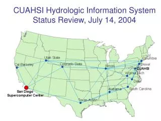
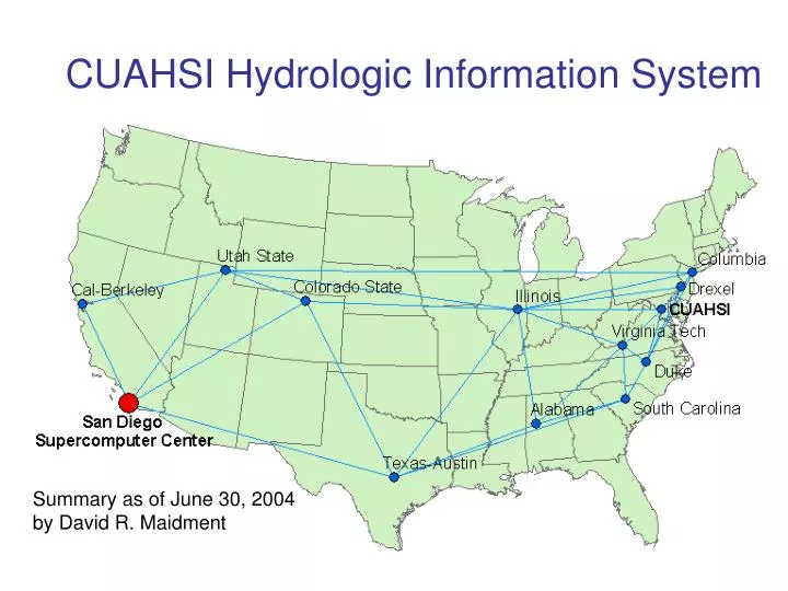
CUAHSI Hydrologic Information System. Summary as of June 30, 2004 by David R. Maidment. CUAHSI Hydrologic Information System Participants. Core Team: D. Maidment , J. Helly , P. Kumar, M. Piasecki , R. Hooper, J. Duncan

E N D
CUAHSI Hydrologic Information System Summary as of June 30, 2004 by David R. Maidment
CUAHSI Hydrologic Information System Participants Core Team:D. Maidment, J. Helly, P. Kumar, M. Piasecki, R. Hooper, J. Duncan Collaborators: V. Lakshmi, X. Liang, Y. Liang, U. Lall, L. Poff, K. Reckhow, D. Tarboton, I. Zaslavsky, C. Zheng
Hydrologic Data Model Time series GIS data Space-time grids Statistics Hydrologic Information System Data Organization Application Systems Process model domains Flux Assessment System Hydrologic Digital Library (Digital files of hydrologic information in any form, indexed by a metadata catalog)
CUAHSI HIS is meant to facilitate: • Data Acquisition • quicker, easier, usable formats • Data Archiving • experimental and regional data for HO’s • Data Assembly • bringing the data together, data model • Data Analysis • visualization, statistics, hypothesis testing.
CUAHSI Hydrologic Information Systems • Work of the five project partners • CUAHSI • San Diego Supercomputer Center • University of Texas • University of Illinois • Drexel University • Involving the collaborators……Ken Reckhow, Yao Liang
Drexel University • Michael Piasecki is PI, assisted by Luis Bermudez • Goal is to study metadata languagesand standards to find what is most suitable for hydrology • Concept hierarchies stored in “ontologies” described in OWL (Ontology Web Language)
Content • Selection of the “base” metadata specification • Expression of the selection using ontologies • Profiles • Tools to extend metadata specifications to allow creation of profiles • Sources for hydrologic vocabulary
Selection of base metadata specification ISO:19115:2003 Mapping will be available FGDC-STD-001-1998 They use ideas in ISO and FGDC ( do not really use their elements ); however they present detail elements to describe format and security constraints EML 2.0.0
ISO Metadata formalized in Ontologies ISO 19115:2003 (Geographic Metadata) http://loki.cae.drexel.edu/~wbs/ontology/2004/04/iso-metadata ISO 19108 (Temporal Schema) http://loki.cae.drexel.edu/~wbs/ontology/2004/05/iso-19108 ISO 19107 (Spatial Schema) ISO 19110(Methodology for feature cataloguing) In progress
FGDC Metadata formalized in Ontology Why ? We can express the mappings in machine readable format How? Java program is coded to convert FGDC XML Schemas to OWL FGDC XML schemas available at: http://www.fgdc.gov/metadata/metaxml.html Extraction of classes and properties and cardinalities Conversion of datatypes and codelistto be done
CUAHSI – Profile V.1.0 • Extend ISO • Set as core (Metadata elements selected to be used by CUAHSI) • Set some mandatory • Create domain list to fit needs Express in machine readable format OWL/XML fully interoperable with original ISO Because of Variety of software and formats
CUAHSI – Profile V.1.0 1) Extend ISO ISO 19108 ISO 19107 ISO 19110 ISO 19115 CUAHSI Profile Because of Variety of software and formats
CUAHSI – Profile V.1.0 2) Set as core Using: “flag” to mark the core elements <owl:AnnotationProperty rdf:ID="core"> core = true Because of Variety of software and formats
CUAHSI – Profile V.1.0 - Security and legal Constraints - Data quality Lineage (including process steps) 3) Set as Mandatory iso:MD_Metadata + metadataConstraints[0..n] : MD_Constraints … cuahsi:MD_Metadata + metadataConstraints[1..n] : MD_Constraints …
CUAHSI – Profile V.1.0 4) New code lists • MD Classification Code for security Constraints • World • Group • Owner
Profiles and subprofiles CUAHSI Profile V.1.0 In progress TimeSeries-Profile Features-Profile … … … Because of Variety of software and formats
Identifying characteristics of elements In progress What can be created by the user? E.g. abstract. What can be created by the metadata software. E.g. metadata version, date of creation. What can automatically be created by the toolscreating the data :E.g. lineage. What can be extracted from files which format is known: E.g. HDF or shape files. Also will be expressed in OWL/XML using an annotation property Because of Variety of software and formats
User profiles To facilitate creation of metadata by reusing resources E.g. Citation Responsible Party Because of Variety of software and formats
Vocabulary in metadata instances • Studied the files located at: http://www.env.duke.edu/cares • Created an ontology with features, attributes and keywords of the ~62 files to depict the heterogeneity problems • Some have FGDC metadata, others do not • Semantic Heterogeneity is found in feature and attributes
How to deal with this problem? In automatic data creation the feature name and attributes could be set a priori (or mapped ) from a hydrologic ontology that supplies the terms. In manual creation of metadata we could map the semantics when uploading files: Similar to Lin, K. and B. Ludäscher work at SDSC mapping geological maps Users map their semantics to a hydrologic ontology. A system should assist making good guesses from previous mappings and ontology inference : Purpose to have a usable ontology
Ontologies construction • Creation of a top hydrologic ontology that is mapped with Wordnet ( the ontology with more usage as of today) • http://loki.cae.drexel.edu/~how/upper/upper.html • Creation of hydrologic units ontology • Extracting hydrologic terms to define feature and attributes : • ARC HYDRO in progress • UNESCO Thesaurus • GCMD • SWEET • GETTY
want this to be very small What is next? Build Metadata descriptions for Neuse_files (initially 2) user “by hand” Core set for anydata set in CUAHSI auto user profile automatically set Data set 1 Data set 2 Data set specific elements and attributes => all in MIF format for HydroViewer
CUAHSI Hydrologic Information Systems • Work of the five project partners • CUAHSI • San Diego Supercomputer Center • University of Texas • University of Illinois • Drexel University • Involving the collaborators……
New Concept of Publication Old Way New Way
HydroViewer GUI Neuse River Watershed Collection HydroViewer Demo by John Helly
SDSC Multiview Map Viewer http://geo.sdsc.edu/website/SIO_Expl/viewer.htm
Wireless telecommunication of water resources data Can we use these data as a prototype for the CUAHSI observatory?
CUAHSI Hydrologic Information Systems • Work of the five project partners • CUAHSI • San Diego Supercomputer Center • University of Texas • University of Illinois • Drexel University • Involving the collaborators……
University of Texas • David Maidment is PI, assisted by Jon Goodall, Gil Strassberg, Venkatesh Merwade • Hydrologic data model development • atmospheric water, surface water, subsurface water • interoperable analysis environment
CUAHSI Hydrologic Information System Experiments Monitoring 1. Assemble data from many sources Information Sources Remote sensing GIS Climate models 2. Integrate data into a coherent structure Hydrologic Information Data Model Hypothesis testing Analysis and Visualization 3. Do science Statistics Data Assimilation Simulation
Digital Watershed:An implementation of the CUAHSI Hydrologic Information Data Model for a particular region Created first for the Neuse basin and then for each of the following CUAHSI Observatory Planning basins
Neuse Basin: Coastal aquifer system Section line Beaufort Aquifer * From USGS, Water Resources Data Report of North Carolina for WY 2002
A 3-D Volume Model of the Beaufort Aquifer Beaufort confining layer Beaufort aquifer Built by Gil Strassberg from borehole information collected by the Neuse basin case study team
RUC20 – Output Samples Precipitable water in the atmosphere Cross-section of relative humidity Wind vectors and wind speed (shading) Images created from Unidata’s Integrated Data Viewer (IDV)
Surface Water Information ArcIMS Web Server displaying data compiled in Neuse HO Planning Study
Neuse basin data in Multiview http://geo.sdsc.edu/website/SIO_Expl/viewer.htm
FromID ToID Feature 1 2 4 2 3 5 Coupling table Where … HydroID of canal feature = 2 HydroID of upstream canal feature = 1 HydroID of downstream canal feature = 3 HydroID of upstream control structure = 4 HydroID of downstream control structure = 5
University of Illinois • Praveen Kumar is PI, assisted by Benjamin Ruddell • Developing “Modelshed” which is an generalized hydrologic modeling and data analysis environment built on top of Arc Hydro • Focused on applications integrating hydrology and climate modeling
Drainage System Hydro Network Flow Time Time Series Hydrography Channel System Arc Hydro Components
What is a Modelshed? • A volumetric spatial model unit, registered in three dimensions by a GIS, with which time-varying data, model fluxes, spatial relationshipsand descriptive metadata are associated
CUAHSI Hydrologic Information Systems • Work of the five project partners • CUAHSI • San Diego Supercomputer Center • University of Texas • University of Illinois • Drexel University • Involving the collaborators……Ken Reckhow, Yao Liang