Download
1 / 26
260 likes | 394 Views
Precipitation Radar Perspectives on Air-Sea Interactions During DYNAMO. Elizabeth Thompson Corvallis PowWow June 24, 2013. Objectives. Present hypotheses for why/how air-sea interactions are important/unique in the IO and to the MJO

E N D
Precipitation Radar Perspectives on Air-Sea Interactions During DYNAMO Elizabeth Thompson Corvallis PowWow June 24, 2013
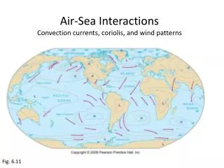
Objectives Present hypotheses for why/how air-sea interactions are important/unique in the IO and to the MJO ... and how our DYNAMO datasets might be used to address these hypotheses Air-Sea communication methods: • Freshwater Flux • Momentum Flux • Radiative Fluxes Important on what time/space scales?
Radar Rainfall Estimation during Dynamo: Thompson et al. 2013, in prep Motivation: • Rain and absorbed IR are primarily responsible for atmospheric (MJO) circulation and diabatic heating structure; vertical motion helps counterbalance tropical heating and maintains weak Temp gradients Goals: • Is DYNAMO rainfall different from TOGA COARE? If so, why? • microphysics • dynamics • large scale environment • MJO maturity • Produce best rainfall estimation product possible for air-sea science applications • limiting factor in parameterization motivations/implementation • Largest source of error from rain rate to cumulative rainfall is sampling error, Methodology: • *** improve attenuation correction • 2DVD data Manus/Gan Islands • EM scattering calculations = radar variables • linear regression to fit power law estimators: Z = a * R ^ b • Use dual-polarized radar data to train single-polarized radar estimation • SPOL & SMART-R @ Gan • Determine statistical significance between rainfall PDFs: before vs. after Freshwater Flux
Freshwater Flux • What role does precipitation play on upper ocean... • stability, buoyancy? • (horiz/vert) mixing coefficients? • surface roughness? • acceleration of sub-sfc jets? • barrier layer & puddle formation/maintenance/erosion? Freshwater Flux
Gan vs. Manus Island 2DVD • Gan Island = subset of Manus Island, so rainfall should be same for DYNAMO and TOGA COARE... • So why are Z-R relationships different? Are they really different? Freshwater Flux
< all 2DVD data log10(NW) = -0.3*D0 + 9.5 Bringi, V. N., C. R. Williams, M. Thurai, P. T. May, 2009: JTECH Freshwater Flux
CONV NCAR/MISMO/TC underestimating rain, not representing C/S zMISMO-NCAR = 178*R**1.44 zTS96_C = 139*R**1.43 zTS96_S = 367*R**1.30 zCSU_C = 61.12*R**1.58 zCSU_S = 200.26*R**1.51 STRAT Freshwater Flux
Aerial Avg. Rainfall Time Series Old Coefficients per hour per day Freshwater Flux
other rainfall metrics: examples?? • PDFs of rainfall/Z • height of maximum echo tops • areal average rainfall Aerial Avg. Rainfall Time Series New Coefficients ***Rainfall rates between single- and dual-polarized radars agree more per hour per day Freshwater Flux
Polar coordinate (high res) convective stratiform partitioning • May have different implications for puddles? • More trustworthy rainfall rates = more meaningful rainfall metrics • already started quantifying this for comparisons • What would a puddle map look like from a particular rain map? Freshwater Flux
Fresh Water Puddle Hunts • How does freshwater flux affect stability of upper ocean and therefore diurnal thermocline cycle? • Are puddles we see at the ship representative of Equatorial Indian Ocean? of the entire radar domain? • Can 150 km radar feature ID / tracking explain observed puddle variability at ship? • actually, let’s just look at a few easy cases, find parents to Aurelie’s orphan puddles. You aren’t going to figure this out on every case, but you should be able to find at least a few cases and understand them really well. The history of the puddle’s parent’s life will be interesting. • How does rainfall contribute to puddle formation/lifecycle/lifetime? • linear vs. MCS vs. popcorn • convective vs. stratiform • volume flux vs. surface flux • Develop/conduct this research WITH Aurelie because she understands the subjects and will see things I won’t have noticed, and vice versa. • ~ 2 D advection model? move around in current (apply over whole domain?), mix together at night? Freshwater Flux
Barrier Layers • How do convective vs. stratiform, organized vs. unorganized, etc. rainfalls contribute to barrier layer formation (at ship)? • What is accumulated effect of different rainfall morphologies (spectrum of convection) to barrier layer production, maintenance, erosion? • sequence, order matters • What is the role of advection? • Important because... • barrier layers favor the maintenance and displacement of WPWP into cent. pacific by isolating the ML from entrainment cooling @depth and by confining the momentum of WWB to shallow ML (Lukas and Lindstrom 1991) Freshwater Flux
rainfall metrics wanted? Write and test puddle detection algorithm (polar coordinates) Barrier layer study status? How could we use precip radar data in puddle model? Collaborate with LIDAR? W-band? to close whole near ship, get upward velocity during stratiform rain? How to evaluate integrated effects, for “ocean memory”: Jim Edson’s capacitor idea Freshwater FluxHypothesisTO-DO List
Colliding Gust Fronts: 22 Nov 2011 Radial Velocity (m/s) Reflectivity (dBZ) Gust fronts are interesting because: • up-scale growth of smaller features into larger MCSs became more frequent before/during MJO initiation • Anecdotally, Gust fronts more frequently noticed at night? • part of erratic storm motion • implications for environmental wind shear and BL recovery Momentum Flux
Gust Front Detection Algorithm END RESULT: • Feature ID and tracking history of: • frequency • intensity • duration • speed, direction • shape, asymmetry • precip • parent storm • storm initiation/mergers Nuts and Bolts: • Scott Collis (ARM) provided automatic unfolding algorithm • Implement special polar coord QC • Look for convergence along gust fronts • look for gradients against smoothed background flow • Only close to radar... • close gap at ship with LIDAR • CYLBIN? Solve for 2D wind field? Momentum Flux
wind stress/gustiness/wind metrics wanted? Implement gust front detection, tracking, and feature ID collaborate with existing DYNAMO cold pool studies collaborate with LIDAR? W-band? how to collaborate with ocean mixing, currents, and ADCP profilers? how to use ADCP spatial data? clear air return? N? contribution to diurnal jets, wrytki jets, EUC, mixing coefficients, turbulence? Wind Stress Hypothesis TO-DO List
Radiative Fluxes @ interface Importance/Focus of air-sea fluxes for MJO: • “For ocean to play a major role in the dynamics of the propagating (initiating) MJO, SFC flux variation must induce SST variation • peak warming anomaly < peak cooling anomaly but suppressed phase lasts longer than active phase and has greater zonal extent. So over life cycle of MJO, WPWP has net heat flux > 0. IDEAS: • assess buoyancy flux into the ML thru air-sea interface (5.10) • insolation, LW flux, latent/sensible heat fluxes • buoyancy flux due to sfc salinity change b/c of evap and rain • buoyancy flux due to heat flux b/c T difference rain vs. sea • stability as a function of depth • ML depth and diurnal cycle of thermocline with metrics of precipitation/clouds • ML depth may have some optimal value... • eq. 5.22 has variation of ML density due to precip, linking horiz mixing coefficient with atm forcing (precip) ... cumulative precip during rain event • composite air-sea fluxes with certain radar resolved “features,” as in RICO, etc. • Assess relative strengths and directions of identified feedback mechanisms • Diurnal cycle of RH >> LHF • SST-Convection • wind-evap-entrainment • cloud-raidative Radiative Fluxes
Radiative Fluxes @ interface II Null hypothesis: extent, frequency, organization, intesity of precipitating systems cannot explain variability (on interannual, accumulated diurnal cycle, diurnal cycle, convective life cycle time scales) in air-sea fluxes. • convective rains induce patchy spatial patterns in sea surface temp/salinity • multi-cloud structures are involved in MJO disturbances • Eq 5.19-5.21 : estimateinhomogeneityof the buoyancy or density field in the upper ocean induced by atm forcing • Is the wind stress/precip timing the same as for TOGA COARE? If not, why? • Implications for MJO dynamical theories? • Are diurnal warm layers critical for afternoon atm. convection? Postulated to progressively moisten lower trop, setting up favorable conditions for onset of organized convection w/in MJO (Godfrey et al. 1998). • use of microprofiler data? • Rainfalls are in fact the major contributor to the temporal and spatial intermittency of the buoyancy flux between atm and ocean in WPWP – so what is the intermittency of the buoyancy flux? • subgrid scale precip statistics w/in 1 km resolution can, in principle, be used to implement horizontal mixing parameterizations in an ocean GCM Radiative Fluxes
What kind of rainfall POINT metrics do you want? Implement cell tracking and feature ID Collaborate with flux group Robust statistical treatment of multivariate datasets? explore text files and equations Radiative FluxHypothesisTO-DO list
Summary ** save something for my PhD prospectus! Important & Quantifiable Precipitation Radar Perspective on Air-Sea Interaction during DYNAMO Lots more ideas and lots more questions Radiative Fluxes Freshwater Flux Momentum Flux ...on what time/space scales?
Mirror MiraiStudy • ISV of SST during boreal winters is large of IOsouth of Eq., where shallow thermocline induces a shallow ML (de Boyer Montegut et al. 2004, Yokoi et al. 2008). This region is called the Seychelles-Chagos Thermocline Ridge. • ISV of SSTs decreases when wind stress increases to deepen ML • Stronger DWLs tend to appear where ISV of SST is greater (Bellenger and Duvel 2009) ... so mirai ≠ revelle • with statistically different rainfall time series, convection populations, DWLs, ocean ML dynamics?... • How are ocean ML and air-sea fluxes different? • What does this say about SCTR? synoptic scale general circulation? equatorial dynamics? • same time period :: 2 locations, regimes, dynamics ~ quasi independent samples?
JPL summer school application: satellite/ climate models Future: Build Parameterizations • Ground based precipitation radar results can be applied to TRMM and GPM satellite radars, although they glaze over the mesoscale because of insufficient resolution • spray/rain-mediated, component of air-sea fluxes - microscale • Transfers energy from sensible to latent heat flux and enhances momentum flux into ocean (for high winds), modifies precip/evap/momentum in atm. BL • Fairall 1994 attempted - how well did you do? Is it a fruitful endeavor to revisit? If so, how? • get rain rate/rainfall right first:large error from space? • Use sea “clutter” to study this in CALWATER2? • Interactive air/sea process parameterizations & sub-models • precipitating systems :: upper ocean • How can we make these subgrid scale process studies relevant and useful to GCMs? Radiative Fluxes Freshwater Flux Momentum Flux
Freshwater Flux NOTES • Null hypothesis: the nature of freshwater pools does not depend on the characteristics/spectrum of rainfall events. • “A hallmark of the MJO is (nearly) coincident westerly wind stress maxima with max freshwater flux into ocean, Hence their individual influence on the buoyancy forcing of the warm pool ML tends to cancel” – Anderson et al 1996, Zhang and Anderson 2003. • Freshwater input produces buoyancy flux from air to sea, which tends to suppress convection initially b/crainT< SST, but may superheat later • since there is a frequent freshwater flux into the ocean, there is a continuous creation, evolution, and dissipation of the density anomalies in the WPWP ~ working toward equilibrium buoyancy spectrum? • turbulent mixing is mainly localized within this stably stratified near-sfc layer. subsequent diurnal warming develops within this freshwater lens. Freshwater Flux
Gust Front Detection NOTES • Null hypothesis: gust fronts, as indicated on PPI radar scans, behave similarly in the eq. IO throughout the MJO lifecycle • We know cold pools are characteristic of their environment and it’s perturbations • How do nature of atmospheric cold pools change with MJO? Convective morphology/lifecycle/intensity? diurnal cycle? • Can radar detected (Lagrangian) gust fronts explain observed variability of gust fronts at Revelle (Eulerian)? • Does gust front detection/evolution provide metrics for boundary layer recovery? • Circulation and mass transport in upper 1 km of ocean is direction related to the curl of the wind stress, then wind driven circulations vanish at a certain depth. • What systematic/anomalous contribution do atmospheric cold pools make to surface wind stress? • isotropic in space/time? • how often? • what direction? >> conv/div • mixing? TKE? • What is the systematic influence of cold pools on the ocean? Do they cancel out over time, Conv/div, wind stress, direction? Romeo and Juliet or Grandpa? • Is there something to be learned/garnered from wave field w/r/t wind forcing? • low level winds and wind stress are correlated to currents on 30-60 day time scale (mcphaden 1982, mysak and pertz) • Anomalous westerlies and easterlies of MJO can excite downwelling and upwelling oceanic KWs, respectively, that in turn affect SST (McPhaden 1999) Momentum Flux
Radiative FluxesNOTES • Net IR flux depends on cloud thickness, height/depth, Atm. WV content • diurnal cycle is more prominent in suppressed phase, so are diurnal warm layers, fresh water puddles, and diurnal jets • clouds/precip are major contributor to horiz temp/salinity gradients. • How muchcooling does it take to convect? Rayleigh number. • surface evap plays controversial role in MJO (Zhange 2005, Sobel et al. 2010), may help increase low-level moisture east of conv. centers thru zonal advection • TOGA COARE provided firm evidence that MJO had coupled atm-ocean structures, which led to surge of theoretical and numerical model studies on the nature of air-sea interactions and their role in maintnatingand developing the ISO. • models operate with integrals rather than instantaneous values of fluxes, so the diurnal amplitudes depend on the history of fluxes; connect mean quantities and gradients to “accumulated fluxes” at air-sea surface. • Heat capacity of top 2-3 m of ocean is as much as the that of the entire atm!! Density is 1000X greater, viscosity 30X greater, vertical length scale 30x smaller === takes much much more time for heat and momentum fluxes from the ocean surface to propagate the same distance they might in atm BL. Radiative Fluxes