Download
1 / 35
350 likes | 666 Views
Desert Basics. Unit 13: Deserts & Wind. Distribution and causes of dry lands. Dry regions cover 30 percent of Earth’s land surface Two climatic types are commonly recognized Desert or arid Steppe or semiarid. Geologic processes in arid climates. Weathering

E N D
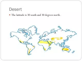
Distribution and causes of dry lands • Dry regions cover 30 percent of Earth’s land surface • Two climatic types are commonly recognized • Desert or arid • Steppe or semiarid
Geologic processes in arid climates • Weathering • Not as effective as in humid regions • Mechanical weathering produces unaltered rock and mineral fragments • Clay • Thin soils • Oxidized minerals • Chemical weathering is not completely absent in deserts. Over long time spans, clay and thin soils do form.
Geologic Processes in the Desert • The role of water • In the desert, most streams are ephemeral-they only carry water after it rains • Dry creeks/streams=arroyos
Flash Flooding in the Desert Why? • So much rain falls that the soil cannot absorb it • Lack of vegetation allows water to quickly run off the land • Floods end quickly!In areas of the Mississippi, it takes days for the flood levels to peak and can take days for them to recede back to normal
A Dry Stream Desert Channel Before and After a Heavy Rainfall
Basin and Range-A Desert Landscape Most desert streams dry up long before they ever reach the ocean. The streams are quickly depleted by evaporation and soil infiltration. Interior drainage into basins produces • alluvial fan—a fan-shaped deposit of sediment formed when a stream’s slope is abruptly reduced • playa lake—a flat area on the floor of an undrained desert basin (playa) that fills and becomes a lake after heavy rain
Basin and Range Most desert erosion results from running water. Although wind erosion is more significant in deserts than elsewhere, water does most of the erosional work in deserts.
Desert Features In The Southwestern United States • The arid climate of the southwestern United States is contributed to two factors: • it is close to 30o North latitude. • and partly because of the rain shadow effect of the Sierra Nevada and other mountain ranges. • Within this region of low rainfall are two areas of very different geologic structure. • The Colorado Plateau • The Basin and Range Province
Desert Features In The Southwestern United States • The Colorado Plateau • Mostly flat-lying beds of sedimentary rock over 1,500 meters above sea level. • They are vulnerable to erosion by the little rain that does fall in the region. • Flat-lying layers of resistant rock, such as sandstone, limestone, and lava flows, formplateaus –broad, flat-topped areas elevated above the surrounding land and bounded, at least in part, by cliffs.. • As erosion removes the rock at its base, the cliff is gradually eroded back into the plateau. • Remnants of the resistant rock layer may be left behind, forming flat-topped mesas or narrow buttes. • A mesais a broad, flat-topped hill bounded by cliffs and capped with a resistant rock layer. • A butte is a narrow hill of resistant rock with a flat top and very steep sides. • Most buttes form by continued erosion of mesas.
Monument Valley, AZ (Photo by David McGeary)
Desert Features In The Southwestern United States • The Colorado Plateau is also marked by step-like folds in rock layers called monoclines. • Erosion of monoclines leaves resistant rock layer protruding above the surface as ridges. • A steeply tilted resistant layer erodes to form a hogback – a sharp ridge that has steep slopes. • A gently tilted resistant layer forms a cuesta – a ridge with one steep side and one gently sloping side. • Neither of these features are unique to deserts, but they are very well exposed in this type of arid climate with sparse vegetation and thin soil.
Basin and Range topography in Death Valley, CA (photo by David McGeary)
Desert Features In The Southwestern United States • The Basin and Range • Although most of the sediment carried by runoff is deposited in alluvial fans, some fine clay may be carried by runoff in suspension onto the flat valley floor. • If no outlet drains the valley, runoff water may collect and form a playa lake on the valley floor. • These lakes are usually very shallow and temporary, lasting for only a dew days after a rainstorm. • After the water is evaporated, only a thin layer of fine mud may be left on the valley floor. • This mud dries in the sun, forming a Playa. • Playa – a very flat surface underlain by hard, mud-cracked clay.
Desert Features In The Southwestern United States • The Basin and Range • Continued deposition near the base of the mountains may create a bajada. • Bajada – a broad, gently sloping depositional surface formed by the coalescing of individual alluvial fans. • Erosion of the mountain can eventually form a pediment. • Pediment – a gently sloping surface, commonly covered with a veneer of gravel, cut into the solid rock of the mountain. • The pediment develops uphill from a bajada as the mountain front retreats.
Alluvial fans and white salt flats of a playa in Death Valley, CA (photo by David McGeary)
Wind in the desert • Transportation of sediment by wind • Differs from that of running water in two ways • Wind is less capable of picking up and transporting coarse materials • Wind is not confined to channels and can spread sediment over large areas
Landscapes Shaped by Wind Wind erodes in the desert in two ways. 1. Deflation is the lifting and removal of loose particles such as clay and silt. It produces • blowouts-shallow depressions • desert pavement—alayer of coarse pebbles and gravel created when wind removed the finer material 2. Abrasion-occurs when windblown sand cuts and polishes exposed rock surfaces
Wind Deposits The wind can create landforms when it deposits its sediments, especially in deserts and along coasts. Both layers of loess and sand dunes are landscape features deposited by the wind. Loess • Deposits of windblown silt • Extensive blanket deposits • Primary sources are deserts and glacial stratified drift.
Wind Deposits Sand Dunes • Unlike deposits of loess, which form blanket-like layers over broad areas, winds commonly deposit sand in mounds or ridges called dunes. • Characteristic features - Steeper on sheltered side, less step on side facing wind - Cross beds are the sloping layers of sand in the dune.
Cross Beds Are Part of Navajo Sandstone in Zion National Park, Utah.
Wind Deposits Types of Sand Dunes • What form sand dunes assume depends on the wind direction and speed, how much sand is available, and the amount of vegetation. - Barchan dunes - Transverse dunes - Barchanoid dunes - Longitudinal dunes - Parabolic dunes - Star dunes
Types of Sand Dunes • Transverse Dunes • form in steady winds, with abundant sand and little vegetation • Ridges are 90º to the direction of wind • Typically in coastal areas • Can be 200 m high • Barchan Dunes • look like crescents • Form on flat, hard ground where supplies of sand and vegetation are limited • Only reach a height of about 30 m
Types of Sand Dunes • Barchanoid Dunes • in between transverse and barchan dunes • Scalloped rows of sand that form at right angles to wind direction • This is what is in White Sands National Monument • Longitudinal Dunes • long ridges of sand parallel to wind direction • Moderate sand supplies and wind direction varies slightly • Can be up to 100 m high
Types of Sand Dunes • Parabolic Dunes • look like backwards barchan dunes • Tips point into the wind instead of away from it • Occur where some vegetation covers the sand • Star Dunes • isolated hills of sand mostly found in the Sahara and Arabian deserts • Bases resemble stars and usually have 3 or 4 sharp ridges that meet in the middle • Form in areas with varying wind direction • Can reach heights of 90 m