Download
1 / 5
50 likes | 206 Views
Geodesy's Critical Contributions to NASA (Earth Science) Defines, maintains and improves the Reference Frame Staying ahead of NASA’s evolving scientific requirements Inter-Connects measurements over space (globally) and time (decades) and technology evolution

E N D
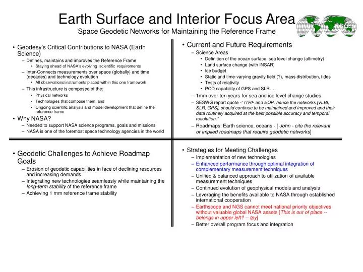
Geodesy's Critical Contributions to NASA (Earth Science) Defines, maintains and improves the Reference Frame Staying ahead of NASA’s evolving scientific requirements Inter-Connects measurements over space (globally) and time (decades) and technology evolution All observations/instruments placed within this one framework This infrastructure is composed of the: Physical networks Technologies that compose them, and Ongoing scientific analysis and model development that define the reference frame Why NASA? Needed to support NASA science programs, goals and missions NASA is one of the foremost space technology agencies in the world Earth Surface and Interior Focus AreaSpace Geodetic Networks for Maintaining the Reference Frame • Current and Future Requirements • Science Areas • Definition of the ocean surface, sea level change (altimetry) • Land surface change (with INSAR) • Ice budget • Static and time-varying gravity field (?), mass distribution, tides • Tests of relativity • POD capability of GPS and SLR…. • 1mm over ten years for sea and ice level change studies • SESWG report quote -” ITRF and EOP, hence the networks [VLBI, SLR, GPS], should continue to be maintained and improved and their data routinely acquired at the best possible accuracy and temporal resolution.” • Roadmaps: Earth science, oceans - [ John - cite the relevant or implied roadmaps that require geodetic networks] • Strategies for Meeting Challenges • Implementation of new technologies • Enhanced performance through optimal integration of complementary measurement techniques • Unified & balanced approach to utilization of available measurement techniques • Continued evolution of geophysical models and analysis • Leveraging the benefits available to NASA through established international cooperation • Earthscope and NGS cannot meet national priority objectives without valuable global NASA assets [This is out of place -- belongs in upper left? -- tpy] • Better overall program focus and integration • Geodetic Challenges to Achieve Roadmap Goals • Erosion of geodetic capabilities in face of declining resources and increasing demands • Integrating new technologies seamlessly while maintaining the long-term stability of the reference frame • Achieving 1 mm reference frame stability
Importance of NASA Space Geodesy Program Provides continuity of observations in space (globally) and time (decades) e.g. sea-level, ice volume, land subsidence and erosion, crustal deformation Provides navigation of satellites, space probes, telescopes e.g. Topex-Poseidon, Cassini, DSN, VLBA Enables NASA science exploration capability in mass transport, ocean circulation, formation flying, remote sensing, physics e.g. GRACE, UAVSAR, ICESat, COSMIC, SCIGN and PBO, SRTM, J2, Lens-Thirring NASA pioneered space geodesy and provides the leadership for space geodesy nationally and globally . e.g. IGS,IVS,ILRS,IERS Strong synergies between Earth-Sun, Solar System, and Universe exploration and communications requirements e.g. positioning, tracking, and pointing within celestial & terrestrial reference frames,DSN, limb sounding and geodetic imaging Critical to national defense and civilian activities e.g. radar calibration, trajectory tracking, gravity fields, navigation, surveying, commerce, flight safety, USNO, NRL, NOAA , EarthScope partnerships Earth Surface and Interior Focus AreaSecond Challenge: Renovation of the Space Geodetic Network The NASA Space Geodesy Program Science and Technology Challenges • Science requires better than 1 mm and 0.1 mm/yr reference frame accuracy • Sea-level change, glacial mass balance, gravity field variability, ocean topography and circulation • Present Frame accuracy is 1 cm or worse • Geodetic systems require replacement before 2010 • Creaking bearings and sagging antennas- • Yarragadee laser station and Gilmore Creek VLBI antenna celebrating 25th anniversaries • Moving on: • GPS,Galileo,GLONASS GNSS signals in transformation • Invasion of XM radio: • VLBI S and X band spectrum squeezed by commercial and government users Strategy for Meeting Challenges • Develop new network technology: • VLBI- test small S, X, K broad- band antenna systems • SLR- Continue development of SLR2000 automated systems • GPS- Develop GNSS capable software receiver and extend functionality to new GPS civil signals • Continue development of real time capability: e-VLBI, GDGPS • Program Development • National Geodetic Observatory study, INDIGO, and GGOS developing geodetic roadmap • Develop ESTO and partnership funding while advancing program with existing program funds • Collaborate with DSN on VLBI and SLR technology development for tracking and communications • Integrate geodetic operations management • Develop synergies e.g. FAA, DoD, Exploration Directorate • Develop new modeling and analysis algorithms • Continued evolution of geophysical models and analysis • Leveraging the benefits available to NASA through established international cooperation • Earthscope and NGS cannot meet national priority objectives without valuable global NASA assets (domestic agencies?) • Better overall program focus and integration
Technologies • SLR • kHz lasers • Automation and 7/24 operations • More accurate retroreflector targets • Saved missions: ERS1, GFO1,METEOR3,…. • Cheap, small, free-flying reflectors in sub-Lageos orbits, carried as secondary payloads – e.g., on GNSS launches, high-inclination science launches • GPS and SLR combined provide very accurate POD • VLBI • Smaller antennas • e-VLBI • Higher rate recording • GNSS (GPS, GLONASS, Galileo) • More frequencies better suited for analysis • Densification of ground systems and filling critical holes • Upgraded receivers (better S/N, new signal structures, etc.) • Expanded LEO tracking • Integration of techniques • Knowledge base integration • Solution-level integration • Observation-level integration • SLR reflectors on all GNSS satellites(?)
Tapley Ries GLOSS - 1mm over ten years- Woodworth SESWG report pg 31 report 1mm/year surface displacement over 50 km Linking Requirements to Sources
Why do we need a reference frame? Long term, systematic measurements of the Earth system require the availability of a terrestrial reference frame (TRF) that is stable over decades and independent of the technology used to define it The space geodetic networks provide the critical infrastructure necessary to develop and maintain the TRF and the needed terrestrial and space borne technology to support the Earth Science Enterprise goals and missions. This infrastructure is composed of the:- Physical networks,- Technologies that compose them, and- Scientific models and model development that define a TRF Current and Future Requirements First among the requirements is the realization and maintenance of the terrestrial reference system, since this is the background to which all local and global variability is tied. Errors in the frame map directly into errors in observable motions and mass changes. (ref Tapley email) 1mm over ten years for Sea level change studies SESWG report quote -” ITRF and EOP, hence the networks[ VLBI, SLR, GPS], should continue to be maintained and improved and their data routinely acquired at the best possible accuracy and temporal resolution.” GGOS? Earth Surface and Interior Focus AreaReference Frame of Space Geodetic Networks • New Technologies • SLR improvements in automation and . (SLR 200) • - VLBI smaller antennas, e-VLBI • - GPS - modernization, Galileo, collective GNSS, densification of reference frame • Challenges • Rusty network and stations, declining resources • Losing capabilities • Need to maintain existing reference frame geodetic systems • New capabilities and technologies must be integrated