Download
1 / 25
250 likes | 316 Views
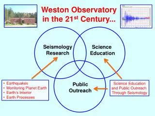
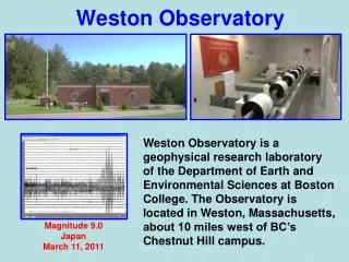
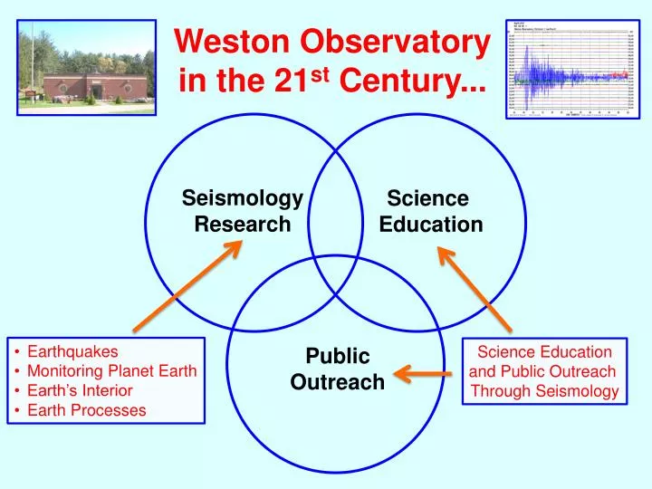
Weston Observatory in the 21 st Century. Seismology Research. Science Educatio n. Earthquakes Monitoring Planet Earth Earth’s Interior Earth Processes. Science Education and Public Outreach Through Seismology. Public Outreach. Recorded at Weston Observatory.

E N D
Weston Observatoryin the 21st Century... Seismology Research Science Education • Earthquakes • Monitoring Planet Earth • Earth’s Interior • Earth Processes Science Education and Public Outreach Through Seismology Public Outreach
Recorded at Weston Observatory Magnitude 6.5 – Bali Sea Magnitude 9.0 Near East Coast of Honshu, Japan Magnitude 6.5 - Japan Aftershock
Boston College Educational Seismology Project Costa Rica Magnitude 7.6 September 5, 2012 Devlin Hall, Boston College Gleason Public Library Carlisle, MA
Recording Earthquakes Epicenter Seismic Waves • Seismic waves are vibrations that travel through the Earth carrying the energy released during an earthquake. • Seismic waves travel outward in all directions, like ripples in a pond.
Virginia Earthquake Recorded at Weston Observatory August 23, 2011
Magnitude 5.8 VIRGINIATuesday, August 23, 2011 at 17:51:04 UTC An earthquake in central Virginia was felt across much of the East Coast on Tuesday, causing light damage and forcing hundreds of thousands of people to evacuate buildings in New York, Washington and other cities. There were no reported deaths, and scattered reports of minor injuries. Air and train traffic was disrupted across the Northeast and mid-Atlantic. Two nuclear plants in Virginia were immediately taken offline after the earthquake. Image courtesy of the US Geological Survey
Where people reported feeling the effects of the Virginia earthquake (green) compared with where a magnitude 6 earthquake in California was reported as being felt (blue). California Magnitude 6.0 September 28, 2004 Virginia Magnitude 5.8 August 23, 2011 Adapted from Horton (2012) (Data from U.S. Geological Survey, “Did you feel it?” website)
PlateTectonics Explains Most Earthquakes But, then there are these “troublesome” (not always so little) earthquakes in the middle of the plates... “Intraplate” Earthquakes
Boston College Educational Seismology Project: Science Education Through Seismology
Boston College Educational Seismology Project Hollis Center, Maine Magnitude 4.0 October 16, 2012 16 sec 16 sec Gleason Public Library Carlisle, MA Weston Observatory
IPL Hollis Center, Maine Magnitude 4.0 October 16, 2012 Ipswich Public Library (IPL) Gleason Public Library (GPL) Boston College (BCD) IPL GPL BCD ALK Alan’s Basement (ALK) 20 sec
Recorded at Weston Observatory Magnitude 6.5 – Bali Sea Magnitude 9.0 Near East Coast of Honshu, Japan Magnitude 6.5 - Japan Aftershock
Magnitude 9.0 NEAR THE EAST COAST OF HONSHU, JAPANFriday, March 11, 2011 at 05:46:23 UTC Japan was struck by a magnitude 9.0 earthquake off its northeastern coast on March 11, 2011: Largest earthquake ever recorded in Japan and the 4th largest earthquake ever recorded in the world. . In downtown Tokyo, large buildings shook violently and there was severe flooding due to a tsunami generated by the earthquake. USGS ~16,000 fatalities Part of houses swallowed by tsunami burn in Sendai, Miyagi Prefecture (state) after Japan was struck by a strong earthquake off its northeastern coast Friday, March 11, 2011. New York Times Japan's worst previous quake was in 1923 in Kanto, a magnitude 8.3 quake that killed 143,000 people.
TIME - MILITARY TIME IN GREENWICH, ENGLAND – GREENWICH MEAN TIME (GMT) OUR CLOCK IS BEHIND 5 HOURS IN WINTER (EST) AND IS BEHIND 4 HOURS IN SUMMER (DST). The black squiggly lines represent ground motion. Date Each line is one hour. Background noise caused by offshore waves, people walking by, ventilator fans, etc……. not earthquake waves. Seismic waves from magnitude 7.1 earthquake - Vanuatu (South Pacific). The present hour is the last line on the screen. Present time minutes
Boston College Educational Seismology Project Costa Rica Magnitude 7.6 September 5, 2012 Devlin Hall, Boston College Gleason Public Library Carlisle, MA
Hurricane Sandy Recorded by Seismograph at Devlin Hall, Boston College Hurricane Sandy in Boston Area Queen Charlotte Islands Earthquake, Magnitude 7.7 Magnitude 6.3 Aftershock October 29 October 28 October 30 Sandy enters Boston area Sandy leaves Boston area October 31 November 1
A fault about the size of New England moved about 40 ft during about 2 min. Japan Mega-Quake Fault Plane of Japan Earthquake Plotted on Map of New England Fault Plane + 1973-1999, M≥5 (Background Seismicity) 03/11/11, M=9.0 (Main Shock) 03/11/11-04/14/11, M≥6 (Aftershocks)
A fault about the size of Boston moved about 1 ft during a few seconds. August 23, 2011 - Magnitude 5.8 Earthquake in Virginia Gleason Public Library Carlisle, MA
~316,000 fatalities Magnitude 7.0 Earthquake in Haiti - January 12, 2010 Photos from: CNN.com and MSN.com
Magnitude 7.0 Earthquake in Haiti Recorded at Weston Observatory January 12, 2010
300 Years of Earthquakes in the Eastern United States 1713-2013 M 7 5
300 Years of Earthquakes in the Northeastern United States 1713-2013 M 7 3