Download
1 / 16
210 likes | 547 Views
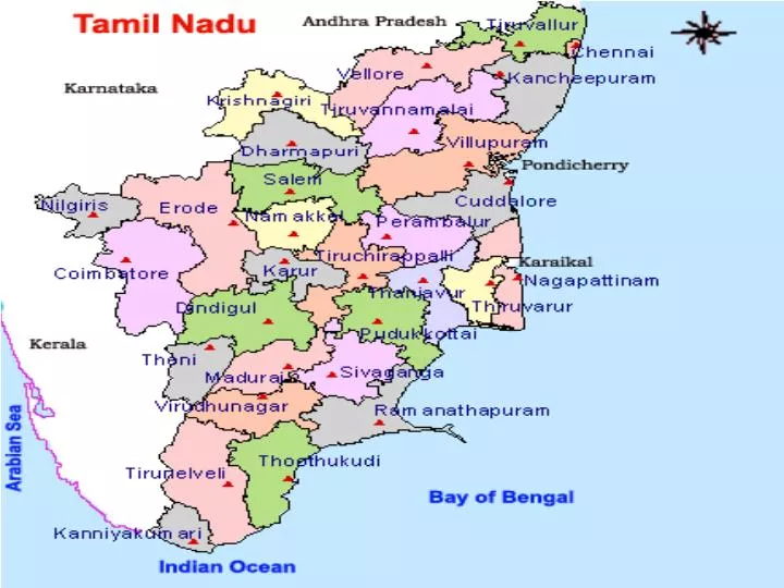
Boundary of Tamil Nadu. North – Karnataka & Andhra Pradesh South – Indian Ocean East – Bay of Bengal West - Kerala. State profile. The state can be divided broadly in to 2 natural divisions. The Coastal plains of South India. The hilly western area.

E N D
Boundary of Tamil Nadu North – Karnataka & Andhra Pradesh South – Indian Ocean East – Bay of Bengal West - Kerala
State profile The state can be divided broadly in to 2 natural divisions The Coastal plains of South India The hilly western area
Coastal Tamil Nadu • Uninterrupted coastline of 922Kms • Includes the coastline of Pondicherry and Karaikkal • The coastline is a lengthy boundary on the east • harbours in Tamil Nadu - • Major ports: Madras • Medium port: Tuticorin • Nagapattinam, Cuddalore & Colochel
Hills in Tamil Nadu • Eastern Ghats • Western Ghats • Shevaroy Hills • Palani Hills • Anamalai Hills
Eastern Ghats • Average elevation – 2000 feet • Beginning in Orissa state run through all the districts lying between Ganjam and The Nilgiris plateau • No river of any great importance runs from these ranges
Western Ghats • 1000 miles in length and run southward and terminate at Cape Comorin, the southernmost exteremity. • Joined by the Eastern Ghat and at the point of junction, from the high plateau of the Nilgiris . • Near Coimbatore District, the range is interrupted by the Palghat Gap. • The south of the gap is known as Anamalai hills and the east of this gap is called Palani hills
Shevaroy Hills • The range is in Salem District with an area of 150 Square miles • Pacahmalai hills - largest hill in this range
Palani Hills • 54 miles in length and 15 miles in width • Area – 800 square mills • Kodaikanal - famous health resort – 7200 feet above the sea level
Anamalai Hills • 80 – 100 square miles • 7000 feet above the sea level • Anaimalai peak - 8837 feet high – • The Nilgiris is the highest point in South India – 8650 feet • Coffee grown in large number • Teak belt
Major Rivers • Cauvery • Vaigai • Thamiraparani • Palar • Ponniyar • Vellar
Cauvery • 475 miles long and drains an area of 28,000 square miles • originates from Coorg in the western Ghats • Across the river, a huge reservoir has been constructed called the “Mettur Dam”. • Near Tiruchirappalli there is an anaicut called “Grand Anaicut” • Colledam – drainage channel of Cauvery
Vaigai • Second most important river in Tamil Nadu • Originates in Varushanad hills • Vaigai dam • Anaicut Dam in Manamadurai
Thamiraparani • 70 miles long • rises in the southern portion of the Western Ghats • drains an area equal to 1937 square miles • The valley of the river contains some of the richest lands in the State • The chief tributaries of the river are – Ramanadhi, Ghatana, Pachaiyar & Chittar
Ponniyar • rises in Nandhi hills in Karnataka State • enters Tamil Nadu near Dharmapuri • drainage area of 620 square miles • has no delta on its mouth
Palar • rises in Nandhi hills of Kolar, Karnataka state • 182 miles long • runs through Chingleput and North Arcot districts. • Chief tributaries – Cheyyar and Ponni