Download
1 / 10
100 likes | 204 Views
Observations and simulations of the wind structure in the boundary layer around an isolated mountain during the MATERHORN field experiment. Stephan F.J. De Wekker 1 , Y. Liu 2 , J.C . Knievel 2 , S . Pal 1 , G. D. Emmitt 3

E N D
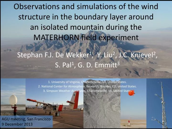
Observations and simulations of the wind structure in the boundary layer around an isolated mountain during the MATERHORN field experiment Stephan F.J. De Wekker1, Y. Liu2, J.C. Knievel2, S. Pal1, G. D. Emmitt3 1. University of Virginia, Charlottesville, VA, United States. 2. National Center for Atmospheric Research, Boulder, CO, United States. 3. Simpson Weather Associates, Charlottesville, VA, United States AGU meeting, San Francisco 9 December 2013
MATERHORN FIELD SITE Looking north Looking south Dugway Range Sapphire Mountain Granite Mountain Granite Mountain Sapphire Mountain
Twin Otter Doppler Wind Lidar TODWL (Twin Otter Doppler Wind Lidar) has been operated since 2002 by CIRPAS (Center for Interdisciplinary Remotely Piloted Aircraft Studies), a part of the Naval Postgraduate School, Monterey, CA. • U,V,W with 50 m vertical resolution, and 1.5 km horizontal resolution • Accuracy: < 0.10 m/s in three wind components • SNR (aerosols) TODWL SCANNER • 2 µm coherent detection • side door mounted scanner conical scans below the aircraft • azimuth angle steps of 30°
Main objectives of MATERHORN- airborne measurements • Provide MATERHORN with high resolution wind data at the mesoscale that provide the background information needed to interpret the many surface-based remote sensing and in-situ observations collected around Granite Mountain • Investigate spatial PBL structure and interaction of boundary layer flows with Granite Mountain
MATERHORN-X Fall - airborne • Twin Otter in Utah between 5 October and 18 October, 2012, participated in 4 IOPs • Missions lasted ~ 4 hours • 7 research flights yielded ~3000 wind profiles between surface and 3400 m MSL Rainfall event quiescent quiescent quiescent moderate
Example Flight pattern 09 October 2012 Afternoon flight (RF03) • Aircraft was based out of Salt Lake City ~ 20 minute to Granite Mountain • Climb to ~ 4 km MSL (~1500 m above Granite Peak) • North-south and east west legs of ~20-30 km • Low level flights
wind pattern 09 October 2012 Upper-level flow Near-surface flow (~400 m AGL)
wind pattern 17 October 2012 Upper-level flow Near-surface flow (~400 m AGL) Afternoon near-surface flow patterns appears unaffected by synoptic flow speed and direction
Preliminary example of comparison with Very Large Eddy Simulation (VLES)for Dugway Proving Ground Near-surface flow (~400 m AGL) 300-m simulation Courtesy of Yubao Liu, NCAR
Summary • 7 successful research fights were conducted during MATERHORN-X collecting data during 4 afternoons and 3 mornings in quiescent to moderate synoptic conditions • Started an investigation of spatio-temporal variability of PBL structure and flow interaction with Granite Mountain • recurring pattern of northerly thermally driven upvalley flows flowing around Granite mountain with channeling through gap. • Very Large Eddy Simulation modeling at 300 m horizontal resolution – shows promising results Outlook: vertical velocities, in-situ aircraft measurement, (fluxes!), organized convective structures/thermal and interaction with flows, assimilation of wind data from airborne Doppler lidar data in WRF, LES simulation at 30-m planned for select cases etc. Acknowledgments: This research is funded by grants from the Office of Naval Research, the Army Research Office, and the National Science Foundation.