Download
1 / 41
410 likes | 592 Views
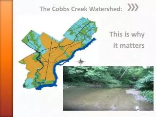
BOOKER CREEK WATERSHED PLAN. WATERSHED ASSESSMENT WETLAND ASSESSMENT POLICY FRAMEWORK. BMP SUITABILITY. CONCLUSION. Paradox: Development occurring in areas where it is least suited and where BMP’s least feasible.

E N D
BOOKER CREEK WATERSHED PLAN WATERSHED ASSESSMENT WETLAND ASSESSMENT POLICY FRAMEWORK
CONCLUSION • Paradox: Development occurring in areas where it is least suited and where BMP’s least feasible. • Overall Booker Creek Watershed is in mediocre condition with much to improve upon • Capitalize on recreational opportunities and environmentally sensitive development • Preserve water quality upstream and mitigate stormwater impacts of development with Pond and Wetland BMP’s.
Vision for Booker Creek Watershed Our vision is to maintain and promote a healthy, functional watershed. We will keep pristine areas protected and maintain suitable areas for riparian vegetation and wildlife. In addition we will maintain high water quality and sustainable development patterns for residential, commercial and recreation areas for current and future generations.
PLAN GOALS • G1: Clean water sufficient to support aquatic life and human uses • G2: Streams that are physically similar to pristine streams • G3: A watershed where flooding does not negatively impact the built environment • G4: Environmentally sensitive land use within the watershed
PLAN OBJECTIVES • O1: Reduce non point pollution in the Booker Creek Watershed 30% by the year 2015. Related to Goal: G1 • O2: Reduce point source pollution emitted into the streams of Booker Creek Watershed 35% by the year 2015. Related to Goal: G1 • O3: Restore stream beds to their natural state of equilibrium by 2050. Related to Goal: G2 • O4: Reduce vulnerability of the built environment in Lower Booker Creek Watershed. Related to Goal: G3, G4 • O5: Increase the amount of land zoned for high density residential development in suitable areas by 25%. Related to Goal: G4
PLAN POLICIES • P1: Establish volunteer water quality monitoring program. • P2: Implement Buffer of 100 feet around perennial, intermittent and headwater streams. • P3: Initiate a radio campaign educating residents about using native plants to reduce fertilizer and pesticide use as well as sediment runoff. • P4: Install watertight covers or inflow guards on all sewer manholes in the floodplain. • P5: Establish monitoring program for toxic waste disposal area in Crow Branch watershed. • P6: Establish a volunteer construction site monitoring program that ensures developers are complying with construction site regulations and increase fines 25% for noncompliance. • P7: Implement Buffer of 35 feet around the 100 year floodplain. (See Map A-5-1) • P8: Require all new developments over 3 acres that border or cross a perennial stream to implement a Pond or Wetland Best Management Practice within 500 feet of stream if land is suitable. The BMP should store water proportional to the amount of impervious surface of that development. BMP’s at sites below 5% impervious cover are not required. (See Maps A-2-1 and A-2-2).
P9: Install Pond or Wetland Best Management Practices within 500 feet of a perennial stream on all developed city-owned property over 3 acres by the year 2015. BMP’s are only required where land is suitable. • P10: Construct raingardens and stormwater catchments for existing and future impervious surfaces exceeding ½ acre. • P11: Stop construction of new sewer manholes in the floodplain. • P12: Undergo clearing and snagging operation in Lower Booker Creek • P13: Encourage cluster development and new urbanist design through tax incentives. • P14: Halt future development in the 100 year floodplain • P15: Pervious surface cover required for 35% of new sidewalks • P16: Stormwater runoff from new development may not exceed predevelopment levels • P17: Encourage Low Impact Development (LID) for all new development proposals by decreasing impact fees for sites that integrate two or more of the following LID methods: • Bioretention facility • Grass Swales • Vegetative Roof Covers • Permeable Pavement • Rain Barrels or Cisterns • No Curb and gutter • Disconnected Impervious Cover
VISION STATEMENT • Our vision is that Booker Creek Watershed will host healthy, functional, clean wetlands. We will improve and sustain healthy hydrological and biological characteristics that create habitat for aquatic life and wildlife. In addition we will have wetlands that have the capacity to prevent damaging floods. Our wetlands will be a place for current and future generations to enjoy the wonders of the outdoors.
WETLAND GOALS • Wetlands that support a diverse native plant community and healthy habitats for wildlife and aquatic life • Adequate water storage and stable banks • Wetlands that are inviting to the community and foster educational programs
OBJECTIVES • Within ten years all wetlands in the watershed will be 50% dominant native species • Improve wetland habitat so that at least fifteen bird species are frequenting the wetlands in five years • Stop development in the floodplain to improve water storage capacity and reduce flooding • Reduce bank slumping by 75% in five years • Ensure that twenty educational programs and civic groups will tour the wetlands within five years • Create a recreational area and handicap-accessible boardwalk in the Eastwood Lake wetland within two years
POLICIES • All proposed developments that are on a property that contains a wetland, or that are within 100 yards of a wetland must undergo a wetland impact evaluation. • Organize civic groups to plant native plant species and remove invasive species for all medium to high quality wetlands twice a year. Medium to high quality wetlands are identified on Map 1 on page 6. APPENDIX 4 lists allowed native plant species to be planted. • Appoint one person, agency, or develop a relationship with a nonprofit, who will be responsible for daily maintenance of wetlands (specifically removal of invasive species
Establish a 100 ft buffer around all wetlands that are of high value • Establish a 75 feet buffer around all medium and low rated wetlands • Install sediment detention ponds in properties that contain or are adjacent to a wetland • Install bioretention cells in Eastgate Mall parking lot and other impervious surfaces in Lower Booker Creek over 2 acres • Start a mitigation bank for undeveloped land • Create zoning ordinance: • No new development in the floodplain • Downgrade density requirements in a 50 foot area around the floodplain • The Town of Chapel Hill will publish a wetland management, restoration, and creation guide to assist developers and landowners whose property contains a wetland. • Create and erect signs in recreation areas near wetlands that clearly define the importance of wetlands. • Develop a relationship with a naturalist at a Nature Center who will lead educational programs in the wetlands • Increase the recreational value of wetlands by building a greenway that extends along the sewer easement in Crow Branch watershed