Download
1 / 16
160 likes | 172 Views
Kaikoura. Tectonic Processes. The Seaward Kaikoura Mountains rise to over 2600 metres just 12km from the sea. The Hope fault, which marks the boundary between the Pacific and Australian Plates, runs along the foot of the Kaikoura Mountains. Kaikoura Orogeny.

E N D
Kaikoura Tectonic Processes
The Seaward Kaikoura Mountains rise to over 2600 metres just 12km from the sea. The Hope fault, which marks the boundary between the Pacific and Australian Plates, runs along the foot of the Kaikoura Mountains.
Kaikoura Orogeny • This plate collision and mountain building event began about 25 million year ago. • In the Kaikoura region, movement between plates changes from ocean floor subduction to continental collision. • As a result, blocks of land uplifted along faults form high mountains right at the coast, & close inshore the sea floor dives to depths of over 1000 metres.
Photographs What type of sediment is this?
What different sediment types can be seen in this photograph? Describe and explain the characteristics of each type.
Use the Kaikoura laminated resource to create two annotated diagrams. Apply your own key. A sketch showing the Geology of the Peninsula. A cross-section diagram outlining the geological structure. Activities
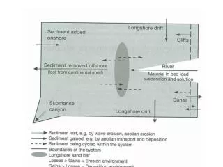
Cross-section diagram • This shows the four folded formations which make up the Kaikoura Peninsula. • The dotted lines indicate land that has been eroded away. • The large scale folds are best seen on the South Bay side of the peninsula; or at the cliffs of Whalers Bay.
Folded limestone rocks form fascinating patterns on the shore platforms that surround Kaikoura Peninsula. What is limestone made of?
Limestone rocks consist of the shells of billions of micro-organisms, compressed on the ocean floor between 70 & 22 million years ago. Water was gradually squeezed out of the accumulating sediments which turned from mud to rock. About 15 million years ago the limestone was buckled and twisted, before being raised above the sea to form parts of the present land and coastline.