Download

1 / 17
170 likes | 259 Views
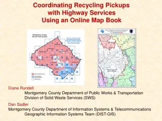
Coordinating Recycling Pickups with Highway Services Using an Online Map Book. Diane Rundell Montgomery County Department of Public Works & Transportation Division of Solid Waste Services (SWS).

E N D
Coordinating Recycling Pickups with Highway Services Using an Online Map Book Diane Rundell Montgomery County Department of Public Works & Transportation Division of Solid Waste Services (SWS) Dan Sadler Montgomery County Department of Information Systems & Telecommunications Geographic Information Systems Team (DIST-GIS)
Online Map Book ProjectThemes • The online map book shows two major Recycling/Refuse map themes: • 1) Recycling/Refuse collection day of the week • 2) Recycling/Refuse Areas • (numbered and assigned to different contractors for picking up recycling/refuse)
Online Map Book Project If trash/recycling trucks have to change their routes, there is potential for: - missing homes - not completing the routes in a timely manner - accidents from trucks turning around in tight quarters
Online Map Book ProjectGoals 1) Provide quick reference for Highway Services to plan road construction around an area’s solid waste collection day 2) Solid Waste Services supervisors can quickly print a map of a specific area if there is a problem out in the field. 3) Inspectors can print maps for a particular area to which they are assigned on a given day and note discrepancies, potential problems, or other items of interest on the maps
Online Map Book ProjectGoals 4) Contractors can print maps for substitute truck drivers 5) Property owners can determine what the collection day in their areas
Online Map Book ProjectIntended Users • Division of Solid Waste personnel • Division of Solid Waste’s contractors for recycling and solid waste • Division of Highway Services personnel • Property owners
Online Map Book ProjectUser Requirments • Enough detail must be viewable in a browser window to discern info for individual blocks • Base map data including street centerlines, major water features, landmark points • The maps must print legibly at 11” x 17” • User-friendly for people who are already using popular ADC Street Maps • Displayed on Intranet & Internet
Online Map Book ProjectData • SWS polygon data: • Recycling/Refuse collection day of the week • Recycling/Refuse Areas • DIST-GIS basemap data: • Street centerlines, with all streets labeled • Landmarks, including schools, police & fire stations, Metro stations, libraries, rec centers • Major water features • Rectangular map tiles (polygon)
Demo of online map book http://gis.co.mo.md.us (click on the “Maps” link)
Online Map Book Project This map book approach has two components: • PDF version of maps for individual tiles • * large amount of detail, users can zoom in • * quality printing, control over printed page 2) Clickable image map used as an index for the tiles * Divide large county into smaller maps
Online Map Book ProjectSoftware Used • ArcView GIS 3.2a • To create the maps • Adobe Acrobat 4 • To create the PDF files • Adobe Photoshop 5.5 / ImageReady 2.0 • To create the clickable image map
Online Map Book ProjectPDF Format • Originally created as an attempt at the “paperless office” concept • Acrobat allows PDF’s to be created from any application • Free Acrobat Reader allows PDF viewing and printing and comes with browser plug-in • Many users are familiar with PDF format from downloading government forms (www.1040.com), online brochures, etc, and seeing links to free download site. • Fonts can be embedded in the PDF document – IMPORTANT FOR MAPS • With PDF format, users are able to print many copies of the same document from any printer (“paperless office”?)
Online Map Book ProjectCreating PDF Tiles • Creating 42 map tiles does not mean creating 42 different maps • After first map tile is created, the remaining tiles can be produced by zooming to each tile and then “printing” to a PDF file • Avenue scripting can actually be used to automate the process if no manual edits are necessary for the individual maps
PDF Tiles Step 1: Create one tile using data that covers the entire study area • Add tile layer and all themes for the entire study area (county) • Start with one of the busier tiles • If you need to autolabel features, be sure to apply it to the entire study area, not just the view • Set up a map layout for the first tile that can be easily adapted for other tiles
PDF Tiles Step 2: Create the remaining tiles – basic ArcView commands • One at a time (process may be automated): • Change Layout elements to reflect the new tile • (title & locator map) • In the View window, select the next tile from in the tile layer, Zoom to Selected, deselect the tile • If necessary, make any manual edits • Create a PDF file by “printing” to the Acrobat Distiller virtual printer
Create Image Map • ImageReady (packaged with Photoshop) will automatically generate the HTML with “hotspots” for you • Hotspots don’t have to be rectangular • ImageReady will also automatically generate javascript if you would like to use rollovers
Demo of online map book http://gis.co.mo.md.us (click on the “Maps” link)