Download
1 / 44
440 likes | 448 Views
USGS Publication For Vertical Control. Inter-agency Datum Establishment And Conversion Collaboration In Missouri. Height Modernization Coordination Meeting. Paul H. Rydlund Jr. PLS U.S. Geological Survey Missouri Water Science Center. USGS GNSS T&M – Why?. “RTK can only be used

E N D
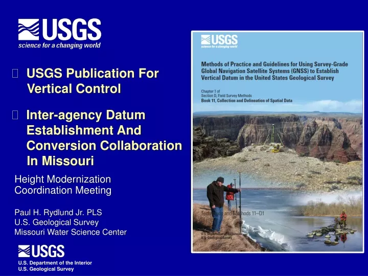
USGS Publication For • Vertical Control • Inter-agency Datum Establishment And Conversion Collaboration • In Missouri Height Modernization Coordination Meeting Paul H. Rydlund Jr. PLS U.S. Geological Survey Missouri Water Science Center
USGS GNSS T&M – Why? “RTK can only be used when setting up directly over a benchmark “ • Technique and Approach Guidance For USGS • Accuracy and Precision • Metadata • Example Campaigns and Decision Trees • Future Direction • Consistent and Referable “Real-Time Network surveys pretty much guarantee vertical accuracies within 2 cm and you never need a base station “ “All post processing GPS surveys must ensure 6 hours of data collection at a minimum“ Global Navigation Satellite System The Black Box “With the new Trimble R8 systems, we are getting vertical accuracies within 7 mm as stated in the data collector “
USGS GNSS T&M - Introduction • Historic USGS Datum Establishment • Evolution • GPS Modernization • GNSS GLONASS, Galileo, Compass • Geodesy Background
Troposphere USGS GNSS T&M - Mission Planning • PDOP • Multipath • Ionosphere & Troposphere • Satellite Availability (Notice Advisory To Navstar Users) • Space Weather (Space Weather Prediction Center) • Resolution and Accuracy of Local Geoid LOOKOUT FOR THESE Ionosphere > 10 km < 10 km
GNSS T&M – Real Time (RT) Surveys • Single Base RT • Network Base RT
GNSS T&M – Real Time (RT) Surveys • Quality Assurances Blunder Check Multipath and General Height Reinitialization Blunder Check - Let’s sum it up! Collectively, the GNSS user observes 180 epochs or 3 minutes of data, walks away from the objective point a minimum of 100 feet, inverts the rover receiver (or adjusts the elevation mask) to lose initialization, changes the rover rod height at least 0.80 feet and corrects the rover height entered in the data collector appropriately, walks a different approach path back to the objective point, then positions the rover receiver in an upright position over the objective point for the second observation. Both observations are averaged to produce the final result. This process is hereinafter referred to as a RT blunder check and should be recorded in the field notes to document that these redundant assurances are met.
GNSS T&M – Real Time (RT) Surveys • Localizations / Realizations
USGS GNSS T&M – Post Processed • Single Base – OPUS • Traditional Static • Rapid Static The USGS GNSS T&M Manual recommends and encourages use of this online utility The experts in geodesy.
USGS GNSS T&M – Post Processed • Network Surveys • Quality Assurances Modified from NOS NGS 59 Tech Memo
USGS GNSS T&M – Quality Categorization • Level I – Static Network Survey • Control • 40 Km spacing; 4 hour; 2nd order or better • Objective • 15 Km spacing; 1 hour; 50% double occupied • Additional benchmark checks other than primary control • Level I – Static Single Base Survey (OPUS-S) • Occupation • 2 Days, 4 hours, different times • Quality Indicators
USGS GNSS T&M – Quality Categorization • Level II – Static Network Survey • Control Points • 60 Km spacing; 4 hour; 2nd order or better • Objective Points • 25 km spacing; 1 hour; 50% double occupied • Additional benchmark checks other than primary control • Level II – Static Single Base Survey (OPUS-S) • Occupation 1 day – 4 hours • Quality Indicators • Level II – RT Surveys • Localization – 2nd order or better • Satellites; PDOP; baseline length • Blunder check redundancy within 0.03 m • Objective points 10% double occupied (within 0.05m)
USGS GNSS T&M – Quality Categorization • Level III – Static Single Base Survey (OPUS-S) • Quality Indicators • Level III – Static Single Base Survey (OPUS-RS) • Quality Indicators • Level III – RT Surveys • Localization – 3rd order or better • Satellites; PDOP; baseline length • Blunder check redundancy within 0.04 m • Objective points 10% double occupied; within 0.05m
USGS GNSS T&M – Quality Categorization • Level IV • Generally reserved for RT topographic surveys without checks • Can be composed of static surveys without quality indicators or checks
USGS GNSS T&M – Metadata (documentation of the geodetic trail) • Benchmark Establishment Recovery
USGS GNSS T&M – Metadata (documentation of the geodetic trail) • Observation • Database storage • lat-long and altitude • metadata
USGS GNSS T&M – Future Direction of GNSS • Modernization programs – L5 signal • GRAV-D • Precise Point Positioning (PPP)
Plug for USGS – GPS Committee http://water.usgs.gov/usgs/osw/gps/
Office of Employee Development (OED) ID1747 Application and Practice of Survey-Grade GNSS Real-Time and Static Surveys in the USGS
Office of Employee Development (OED) ID1747 Application and Practice of Survey-Grade GNSS Real-Time and Static Surveys in the USGS Syllabus
Office of Employee Development (OED) ID1747 Application and Practice of Survey-Grade GNSS Real-Time and Static Surveys in the USGS
Office of Employee Development (OED) ID1747 Application and Practice of Survey-Grade GNSS Real-Time and Static Surveys in the USGS OPUS Projects
Office of Employee Development (OED) ID1747 Application and Practice of Survey-Grade GNSS Real-Time and Static Surveys in the USGS
Office of Employee Development (OED) ID1747 Application and Practice of Survey-Grade GNSS Real-Time and Static Surveys in the USGS
Office of Employee Development (OED) ID1747 Application and Practice of Survey-Grade GNSS Real-Time and Static Surveys in the USGS
Levee Breach PROJECT APPLICATION – Storm Surge Sensors The New Madrid Floodway
PROJECT APPLICATION – Storm Surge Sensors What’s up with Sandy…
Legacy Datum - Mississippi River Datum and Some Tributaries • Memphis Datum • Mean Gulf Datum • Fourth General Adjustment of 1912 Historic datum is considered legacy
Legacy Datum – Middle Mississippi River Datum – St. Louis Gaging Station Historic datum is considered legacy
NAVD 88 Datum Conversion : Simple Height Conversion or Survey – “The USGS Missouri Model” 1. Evaluation of Source Datum 2. Cooperative Interest 3. Hydraulics and Stability 4. Accuracy assured with USACE ‘CEPD’ and NWS modeling interests Source Datum genesis and condition Cooperative Interest Cooperative Interest Accuracy Gage location hydraulics or channel instability
Inter-Agency Collaboration in Missouri Missouri River Datum Discrepancy Example
Benefits of Inter-Agency Collaboration • Enhance Resources • Reduce Expense • Quality Assurance • Agency Consensus • Public Approval
Continuing Inter-Agency Collaboration in Missouri • Datum Surveys – Moving Forward • USGS and USACE duplicative surveys at important gaging locations • Main stem Missouri and Mississippi River gages • Water resource operation project gages • Limited duplication at tributary gages • USGS / USACE surveys • Sharing of metadata and results • Overcome cost prohibitive gaging locations • Augmenting staff for local/regional GNSS campaigns • USGS Gaging Installation • Installation of an observable benchmark Datum Dissemination
Continuing Inter-Agency Collaboration in Missouri Survey assistance…. MODOT MVL USACE NWK MVS SWL MVM MDNR
Continuing Inter-Agency Collaboration in Missouri – FY 13 USGS Missouri Water Science Center Observations per T&M (Level I) USACE – SWL USGS - MOWSC USGS - ARWSC
Inter-Agency Collaboration Datum Surveys – Assistance and Collaboration http://www.ngs.noaa.gov/ADVISORS/AdvisorsIndex.shtml
Inter-Agency Collaboration Datum Surveys – Assistance and Collaboration Mark.W.Huber@usace.army.mil