Download
1 / 32
320 likes | 327 Views
This article introduces the instrumentation and approach for surveying and flow gauging in order to quantify the fluxes of water, sediment, and elements in a given channel. It covers topics such as Manning's equation, floods and bankful discharge, and obtaining and understanding watershed flux data.

E N D
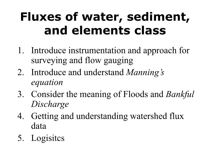
Fluxes of water, sediment, and elements class • Introduce instrumentation and approach for surveying and flow gauging • Introduce and understand Manning’s equation • Consider the meaning of Floods and Bankful Discharge • Getting and understanding watershed flux data • Logisitcs
1 FLOW GAUGING • QUANTIFY VOLUME OF WATER MOVING THROUGH CHANNEL • NEED CHANNEL GEOMETRY • NEED VELOCITY
1 Survey Across Stream Distance Velocity Water Depth
1 The auto level Your view
1 Level the instrument :( (:
1 TOP = DISTANCE BOTTOM = DISTANCE CENTER LINE - ELEVATION D
1 Good Data Table is key
1 Flow meter for measuring water speed
1 Divide and Conquer
1 Add up the pieces
1 From counts to speed
1 Stage and Discharge related through rating curve
1 Water Resources of North Dakota The top of a U.S. Geological Survey staff gage (a graduated rod against which water levels can be read) is barely visible above the water.The top of the gage represents a water level or river stage of 54.50 feet, 2 feet above the 1997 East Grand Forks city levee.During the 1997 flood, the Red River crested at 54.35 feet; the National Weather Service flood stage at Grand Forks is 28.00 feet.
1 WEIR is the permanent solution Q = 2.47h2.5
2 Manning Equation Use fudge factor of 1.49 when units are feet
2 SLOPE
2 Wetted Perimeter
2 http://wwwrcamnl.wr.usgs.gov/sws/fieldmethods/Indirects/nvalues/ Boundary Ck at Porthill, Idaho n = 0.073 Clark Fork at Missoula, Montana n = 0.030
3 Flow Levels Try to define in field using observations Bank full flow About once a year “Channel-forming flow” This is for alluvial channels
3 Extreme Floods How does the Huntington Fit?
3 DEFINE BASIN AREA COUNT BOXES OR USE DIGITIZER
4 Sediment Transport Through Rivers Bedload -- material moving along the bed, shear forces exerted by water sufficient to move clasts -- rarely measured (at % level) Suspended Load -- material kept in the water column by turbulence and lift forces (easy to measure in grab samples) Dissolved Load -- material in solution (easy to measure in grab samples) Bedload usually <<< than suspended load and ignored Dissolved load varies, usually < than suspended load
4 Sampling for suspended load…….
4 Mass Loadings and Erosion Rate Estimation Integrate suspended load over all flows (mass/time) + Integrate bedload load over all flows (mass/time) + Integrate dissolved load over all flows (mass/time)
USGS Water Quality Data on lineDissolved and Suspended Load http://nwis.waterdata.usgs.gov/nwis/qwdata?site_no=04282815&agency_cd=USGS&begin_date=&end_date=&format=html_table&inventory_output=0&rdb_inventory_output=file&date_format=YYYY-MM-DD&rdb_compression=file&qw_sample_wide=0&submitted_form=brief_list
4 Integration over all flows is a non trivial problem!Need Rating Curves (suspended, dissolved, bedload) Suspended Load Hysteresis loop
4 Other Approaches…Reservoir trapping (may miss dissolved) Nahal Yael, Negev Desert
4 SEDIMENT YIELD - What comes out = or ≠ Timescale Steady state Human impact Episodic disturbance SEDIMENT GENERATION - Material generated by erosion
River Lab Logistics • On Huntington, in water • Warm clothes, food, $, Daily Bread • Measure discharge - survey and velocity • Trace flow • Compare pools and riffles • Field estimate of bankfull stage • OLD TENNIS SHOES! Teva/toenail story
Downstream Organization Survey one of each type Calculate discharge for one of each type Calculate roughness for one of each type COMPARE