1 / 0

Eastern Great Basin July – October, 2014 Fire Potential Outlook

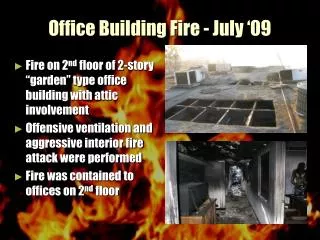
Eastern Great Basin July – October, 2014 Fire Potential Outlook. Shelby Law EGBCC Predictive Services Meteorologist. Contents. Current Fire Danger Observed Fire Occurrence/Fire Behavior July Weather/Fire Potential Forecast August Weather/Fire Potential Forecast

jayden
Download Presentation

Eastern Great Basin July – October, 2014 Fire Potential Outlook

An Image/Link below is provided (as is) to download presentation Download Policy: Content on the Website is provided to you AS IS for your information and personal use and may not be sold / licensed / shared on other websites without getting consent from its author. Content is provided to you AS IS for your information and personal use only. Download presentation by click this link. While downloading, if for some reason you are not able to download a presentation, the publisher may have deleted the file from their server. During download, if you can't get a presentation, the file might be deleted by the publisher.

E N D

Presentation Transcript


  1. Eastern Great Basin July – October, 2014Fire Potential Outlook

    Shelby Law EGBCC Predictive Services Meteorologist
  2. Contents Current Fire Danger Observed Fire Occurrence/Fire Behavior July Weather/Fire Potential Forecast August Weather/Fire Potential Forecast September/October Fire Potential Forecast
  3. Current Fire Danger
  4. Recent Weather Trend Temperatures for the past 30 days have been near to slightly below normal over the north and normal to slightly above normal across the south. The overall weather pattern has been fairly progressive recently, with periods of hot and dry followed by periods of cool and wet, mainly over the north. The most significant weather anomaly for the past 30 days was the extremely dry air mass that spread over the area at the end of May and into the first half of June. This dry air hastened the drying of live fuels across much of the Eastern Great Basin. Sagebrush values quickly plummeted from near normal in mid-May to near record lows by mid-June. These low values have stabilized somewhat going into July but are still below normal for the time of year. Drought conditions have changed little over the past month with moderate to severe drought continuing across much of Utah and the AZ Strip. The drought is expected to improve through the summer months over Utah as the El Nino develops. The drought is a little worse along the Snake River Plain in Idaho with a bull’s-eye of extreme drought over south central Idaho.
  5. Recent Weather Trend Temperature Departure from Average Precipitation Percent of Average 6/01/2014 - 6/30/2014
  6. Drought Monitor and Outlook Drought Monitor Drought Outlook
  7. Energy Release Component Southwest ID Western Wyoming Northwest UT Southwest UT
  8. Fuel Moisture - Sagebrush Southwest Idaho Southeast Idaho Northwest Utah Southeast Utah
  9. Fuel Moisture – 1000-hr Western Idaho Mtns Southern Utah Mtns
  10. Fuel Loading – Grasses The 2014 grass crop is close to normal across Idaho and northern Utah. West central and southwest Utah have a below normal grass crop Southeast Utah has a normal to above normal fuel loading.
  11. Observed Fire Occurrence / Fire Behavior YTD fire occurrence has been close to normal, but acres burned is much below normal due to the recent cool and wet weather. Moderate fire behavior has been observed on dry, windy days.
  12. July Climate Outlooks
  13. July Fire Potential Outlook July is normally a busy month for fire activity across much of Utah and Idaho. Fire activity is expected to be close to ‘normal’ this year for Utah and eastern Idaho where mild weather conditions should moderate the drought stricken fuels. Western Utah may be on the edge of the deeper monsoon moisture this year and may become a focus area for new Initial Attack. The slightly above normal grass crop in southwest and south-central Idaho combined with the underlying drought conditions will likely result in ‘above normal’ large fire potential for that area during the month. A small area of ‘below normal’ fire potential exists along the northeast fringes of the geographic area where the boundary lies between dry conditions in southern Idaho and wetter conditions over Wyoming and Montana.
  14. Long Term Climate Outlooks
  15. August Fire Potential Outlook Elevated large fire potential continues into August over southwest and south central Idaho. This area may expand to include portions of the west and central Idaho mountains depending on the July weather pattern. Utah will likely see some fire activity during the month as dry periods return to the state in between surges of moisture from the south.
  16. Sep/Oct Fire Potential Outlook Overall large fire potential is expected to decrease by mid-September area wide according to a normal schedule.
  17. The End

    Send Questions/Comments To Shelby Law, EGBCC slaw@blm.gov
More Related