Download
1 / 9
90 likes | 227 Views
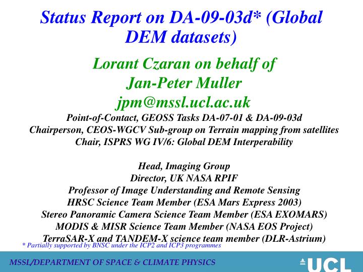
Status Report on DA-09-03d* (Global DEM datasets). Lorant Czaran on behalf of Jan-Peter Muller jpm@mssl.ucl.ac.uk Point-of-Contact, GEOSS Tasks DA-07-01 & DA-09-03d Chairperson, CEOS-WGCV Sub-group on Terrain mapping from satellites Chair, ISPRS WG IV/6: Global DEM Interperability

E N D
Status Report on DA-09-03d* (Global DEM datasets) Lorant Czaran on behalf of Jan-Peter Muller jpm@mssl.ucl.ac.uk Point-of-Contact, GEOSS Tasks DA-07-01 & DA-09-03d Chairperson, CEOS-WGCV Sub-group on Terrain mapping from satellites Chair, ISPRS WG IV/6: Global DEM Interperability Head, Imaging Group Director, UK NASA RPIF Professor of Image Understanding and Remote Sensing HRSC Science Team Member (ESA Mars Express 2003) Stereo Panoramic Camera Science Team Member (ESA EXOMARS) MODIS & MISR Science Team Member (NASA EOS Project) TerraSAR-X and TANDEM-X science team member (DLR-Astrium) * Partially supported by BNSC under the ICP2 and ICP3 programmes
GEO Task DA-09-03d : Global DEM • Supported by BNSC-CEOS with Point of Contact: Prof. J-P Muller (CEOS-WGCV) and WGISS activities led by W. Cudlip (Qinetiq) • Objectives are to • Facilitate interoperability among Digital Elevation Model (DEM) data sets with the goal of producing a global, coordinated and integrated 30m DEM of the Earth’s land surface and continental shelves • Envisaged ASTER GDEM to form the land part of this global 30m DEM • Continental shelf bathymmetry still a major issue, need for GEO pressure • This DEM database should be embedded into a consistent, high accuracy, and long term stable geodetic reference frame for Earth observation. • Planned activities include: • Successive open calls for validation of ASTER GDEM quality (12/08, 4/09, 6/10) and presentation of results through online proceedings of workshops, subsequent peer review journals. • Open display of ASTER GDEM quality through the CEOS-WGISS ICEDS (3/10). • Open display of errors and artifacts through “Known Product Issues” web service (3/11). • Promotion of continental shelf bathymetry acquisition starting in north polar region through ESA/CSA MORSE programme (6/10). • 40 members involved in Task (UK, US, AU, DE, FR, IT, ES, JP, CN, KR, WMO, OGC)
Status-Overview : GEO DA-09-03d: Global DEM* • Validation of ASTER GDEM at 1 arc-second (≈30m) currently being completed by NASA/USGS with METI/ERSDAC. • USGS released an “Announcement of Collaborative Opportunity” on 2.12.08 with a closing date for proposals of 7.1.09. 21 non-US groups submitted validation results by 21 March 2009 • JPM evaluated ASTER GDEM quality for 5 tiles (maximum permitted), 4 of which were over CEOS-WGCV test sites • Around 1% of the total 22,495 tiles have been evaluated by these 21 groups outside of the US and around 3% by NGA and USGS • USGS hope to have joint validation report completed in the next few months for possible release of the ASTER GDEM no earlier than June 2009 • Current METI/NASA release policy states limits on the maximum number of tiles permitted for each order although all data will be free • Only 1º x 1º tiles to be released to registered users through ERSDAC and USGS-EDC. Conditions on subsequent use not known at present time * thanks to Bryan Bailey for providing this in difficult circumstances
GDEM Stacking Number 10 5 0 20 15 Stacking Number Michael Abrams, JPL ISRSE, Stresa, Italy, May 2009
Susquehanna Test Site 10 – 22 Scenes 1 – 9 Scenes Prototype ASTER GDEM Number of Scenes Used to Produce Prototype ASTER GDEM Michael Abrams, JPL ISRSE, Stresa, Italy, May 2009
ASTER intercomparison over CEOS-WGCV North Wales site Example of ASTER vs GPS vs SRTM vs BlueSky vs GLC2000
Activities planned in the next 6 months: GEO DA-09-03d: Global DEM * • JPM plans to provide his next report to CEOS-WGCV Plenary #30 in Brasil, 25-29 May 2009 • JPM has co-convened with Dean Gesch (USGS) a 10-talk CEOS-GEO-ISPRS workshop on 17 July 2009 on the ASTER GDEM validation to take place as part of IGARSS09 in Cape Town, South Africa from 13-17 July 2009 • This session will include the launch of an international programme to perform further ASTER GDEM quality assessment and to launch a “user report” wiki • UCL still plan to create a WMS of ASTER GDEM probably using existing GUI as well as a moderated “Known Issues” wiki • all of these activities are subject to BNSC funding decisions to be made shortly
GEO DA-09-03d: Global DEM : Next Steps(1) • Focus for land on FULL PUBLIC RELEASE of entire ASTER GDEM (22,895 tiles) via anonymous ftp with no limitations on the number of tiles or on any subsequent use (similar conditions to SRTM) to meet GEO data policy goals • WGISS Plenary support for WMS display of ASTER GDEM for inter-comparison with other datasets either at EDC and/or on UCL-ICEDS and/or elsewhere • Need investigation of feasibility of providing updates from other data sources as and when available so that we have a true shard community to contribute to Global DEM including credit being given • Need for global validation and assessment to determine those regions which need to be enhanced with other EO-derived DEMs. Focus initially on use of SRTM-X which is going to be released by DLR in the public domain shortly. • Require support from CEOS member space agencies to provide missing or poor data quality (e.g. CNES/SPOT5, ISRO/Cartosat, JAXA/ALOS-PRISM) as well as TerraSAR-X stereo. • DLR TANDEM-X unlikely within 2011 timescales. However, this will provide the next generation (DTED-3, 10m) DEM
GEO DA-09-03d: Global DEM : Next Steps (2) • Requires massive mobilisation of resources for bathymmetric data acquisition, validation of entire datasets and data dissemination. • Needs support from UN for countries to release data input to “Law of Sea” process. Treaty still a controversial issue in the US • Christopher Fox (Director, NOAA-NGDC) to present a talk on behalf of JPM at GEBCO Brest meeting on Global DEM. Unfortunately due to schedule conflicts which cannot be changed, JPM cannot attend. Volunteers welcome! • What role could EO play in bathymmetry sounding using lidar (e.g. NOAA SHOALS instrument from space)? • Proselytise the value of this 30m DEM/bathymmetry dataset by showing example applications on the web and inviting the international community to provide further examples relevant to their own situation