Download

1 / 41
410 likes | 558 Views
NRCS National Water and Climate Center. Bruce Newton Acting Director National Water Quality Monitoring Council Meeting December 8, 2003. Mission. Snow survey and water supply forecasting Soil Climate Analysis Network Climate data for conservation planning Technical tools and support for:

E N D
NRCS National Water and Climate Center Bruce Newton Acting Director National Water Quality Monitoring Council Meeting December 8, 2003
Mission • Snow survey and water supply forecasting • Soil Climate Analysis Network • Climate data for conservation planning • Technical tools and support for: • hydrology • nutrients, pesticides, animal waste, water quality • air quality • irrigation and water management
Locations and staffing Amherst, 2 staff Great Falls, MT Portland, 33 staff Beltsville, 6 staff West Lafayette Ft. Collins Durham, NC Lafayette, LA
Snow Survey / Water Supply Whiskey is for drinking; water is for fightin’ over.- Mark Twain • 50-80% of useable water derives from mountain snowpack. Snowpack highly variable year to year. • Snow monitoring and water supply forecasts are essential to the western economy
Snow Survey / Water Supply • Users of NRCS data and forecasts: • irrigation districts and farmers • hydroelectric utilities • reservoir operators • flood managers • disaster management agencies • wildfire managers • recreation interests
Snow Survey / Water Supply • 709 Locations • 12 States • Jan-Jun • 11,411 Forecasts
Manual Snow Survey • 1100 sampling sites • Sampled 2 - 4 times a year • NRCS field office staff and many cooperators • Majority are candidates for automation
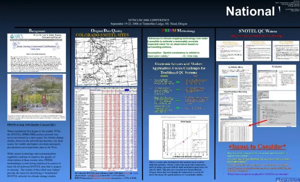
Remote Stations (SNOTEL) • 702 stations in 12 States • approximately 10 new stations added per year • located in high elevation mountainous areas • three communication master stations relay data to NWCC Data Center
Wind Solar Radiation Air Temp Relative Humidity Snow Depth Snow Water Equivalent
Snow Survey / Water Supply • Resource investment: • 61 full time NRCS staff • 22 at NWCC • 39 at State level • Additional staff on part time basis • Portland Data Center • Electronics Maintenance Facility • Equipment investment of $30 million (replacement cost)
Data Center Operations • Major data center within NRCS configuration responsible for snow survey and climate data systems • 900,000 monitoring observations per week incoming • 24/7 operation • System is classified mission-critical by Department
Data Center Operations • Resource investments • seven NRCS staff dedicated to IT • we use programming services contracts • expenditures for hardware, software, and operations run one million dollars per year.
New Usage Measure • Counting web hits and FTP downloads is flawed • Developed a new measure narrowly focused on user access to snow survey data and forecasts • For FY03 there were 3.9 million user accesses
FY04 Priorities • Upgrade SNOTEL stations • replace obsolete station transceivers and data loggers • soil moisture and other sensors • Data Center software and products • Pilot test short-term forecasting • Expand staffing as resources allow • Improve data QA
Strategic Issues • Short-term streamflow forecasting • issue short-term discharge forecasts in addition to current seasonal volume forecasts • System automation • replace manual snow courses with SNOTEL stations
Short-term forecasting • supplement seasonal volume forecast with short-term discharge forecast • peaks; onset of low-flow • currently forecasting 29 basins in MT • 2-week forecast • issued weekly
Short-term forecasting • major resources implications • pilot project • various models • various potential partnerships • NWS • State agencies
System automation • about 40% of the snow survey system is automated • forecast accuracy improved • important for short-term forecasting
SCAN Soil Climate Analysis Network
SCAN • Climate and soil moisture monitoring to • support farm operations (planting, waste spreading, irrigation scheduling) • improve drought assessment and flood forecasting • to advance scientific knowledge of soil hydrology and climate relationships
SCAN • Stations located in low elevation agricultural areas • Joint with National Soil Survey Center • Expanding primarily through cooperator funding • Utilizes the SNOTEL infrastructure for design, equipment, data management, user access to data
SCAN • Principle cooperators: • USDA World Agricultural Outlook Board, ARS, FS • Land Grant Universities • State Climatologist Offices • Regional Climate Centers • Principle users: • local farmers • WAOB • researchers • State climatologists • Weather Service
SCAN • Currently 85 stations in 41 States • Demand for new stations to be paid for by partners exceeds our ability to install and maintain them • Greatest need is for technician-level staff and data QA analysts
Climate Services • Climate is a major factor in natural resources management • Climate data are used extensively by our conservationists and partners in planning • Our role is to coordinate research, obtain data, complete value-added analyses, and make information easily accessible to resource professionals
Climate Services • Provide expertise, analyses, and data for • wetland determination • county soil surveys • water supply forecasting • air quality assessments • erosion estimation • crop planning and risk assessment • water quality models
PRISM World recognized technology to analyze and map climate using GIS
Ag. Climatology Work with other agencies to develop climate information and improve accessibility • climate generator for modeling • serially complete data sets • wind data analysis for air quality • Internet-based access and analysis of climate data (ACIS)
Technology Support Water Quality Animal waste engineering Nutrient management Pest management Hydrology Air Quality Irrigation and Water Management