Download
1 / 51
530 likes | 688 Views
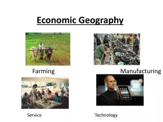
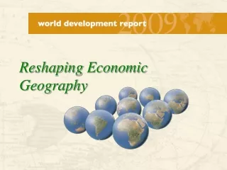
Reshaping Economic Geography. Three prosperous places. Tokyo—the biggest city in the world 35 million out of 120 million Japanese, packed into 4 percent of Japan’s land area USA—the most mobile country

E N D
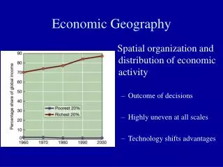
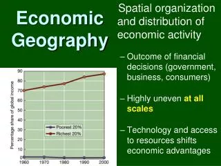
Three prosperous places • Tokyo—the biggest city in the world • 35 million out of 120 million Japanese, packed into 4 percent of Japan’s land area • USA—the most mobile country • More than 35 million out of 300 million changed residence in 2006; 8 million people changed states • West Europe—the most integrated continent • About 35 percent of its GDP is traded, almost two thirds within the region
Packing in Tokyo’s subways Tokyo’s “trainpackers” crush commuters into metrorail carriages
Economic density—why the Japanese agglomerate Japan’s economic mass is concentrated in the Tokyo-Yokohama area
In Belgium, too The economic landscape is bumpy, even in a small, developed, Western European nation 5
Going home in the US Planes in the air on the Tuesday before Thanksgiving in the US
Economic distance—what Americans reduce by migrating Economic mass is concentrated in a few parts of a big country
The fruits of specialization Airbus parts are made, moved, and assembled all over Western Europe
Low economic divisions—what allows Europe to specialize Thin borders in Europe, thick in Africa
Made possible by common institutions Growing institutional integration in Western Europe Source: Dorrucci et. al. (2002, 2004)
The result? The US, EU-15, and Japan cover much of the economic globe
Three prospering places • Mumbai—the most densely populated city • About 30,000 people per sq. km.; already twice the population density of Seoul, Shanghai, and Bogotá • China—the most mobile developing country • 60 million migrant workers traveled from home on the last day of Chinese New Year holidays in 2006 • 200 million travelers were stranded due to snow storms days before Chinese New Year in 2008 • Southeast Asia—the most rapidly integrating developing region • Trade is a big part of GDP • More than 25 percent of its trade is within Southeast Asia; more than 50 percent if Northeast Asia is included
Trainpackers needed People die every day on Mumbai’s trains
Why Mumbai attracts migrants Economic density is high in and near Mumbai
Going home in China Guangzhou railway station during Chinese New Year, 2008
Specialization and trade in East Asia Computer parts are made and assembled all over East Asia
Exploiting economies of scale in East Asia, to access world markets Vigorous trade flows in East Asia, anchored by China and Japan
The result? China, India and Southeast Asia can again be recognized on a map of the world’s economic geography
Geographic transformations needed for progress • Higher Densities • Few countries have grown to high income without large cities • Shorter Distances • Growth seldom comes without mobile people • Fewer Divisions • Growth seldom comes to a country that is isolated from others
WDR 2009 structure The report can be read by part or by policy
WDR 2009 messages • Growth will be unbalanced—concentration is the rule • Trying to spread out economic production amounts to fighting the forces of economic growth • Development can still be inclusive—convergence is the objective • Persistent spatial disparities in basic living standards are neither desirable nor inevitable • Geographic transformations are needed for combining unbalanced growth with inclusive development—integration is the answer • Don’t focus narrowly on places that are not doing well, focus instead on their economic interactions with places that are doing better
Policy makers tend to focus on spatial targeting first, and foremost The debates on urbanization, decentralization and globalization tend to focus narrowly on lagging places, and on targeted interventions
Policy makers should use all instruments of integration Common institutions and connective infrastructure are the most potent instruments for economic integration
Geographic scales The report examines policy issues at the local, national and international geographic scales
Integration gets harder… …. as urbanization advances, and more policy instruments are needed Institutions to encourage density in Popayan, Colombia Institutions and infrastructure to encourage density and reduce distance in Bucaramanga, Colombia Institutions, infrastructure and interventions to encourage density, reduce distance, and lower divisions in Bogota 26
Urban settlements provide different services Human settlements do different things • Towns facilitate internal scale economies • Cities encourage localization economies • Metropolises generate urbanization economies Popayan, Colombia Bucaramanga, Colombia Bogota, Colombia
The importance of land markets A simple framework for tailoring urbanization policies to the economic geography of places
Seoul in the 1950s Cheonggye river, and the biggest slum in Seoul Source: Aving,network 29
Seoul in the 1970s A highway is built on the river, through and over the slums Source: Aving,network 30
Seoul in the 1980s More infrastructure and new businesses next to Cheonggye-cheon, the slums were moved to other parts of the city Source: Aving,network 31
Seoul in 2009 Cheonggyecheon in 2005: Mayor Lee Myungbak, the current president of South Korea, removed the highway and recovered the riverfront Source: 32
Territorial development policies—when lagging areas have high poverty rates, but most poor are in leading areas A 1-D problem of national economic integration in China: The dimension—economic distance; the instrument—institutions that unify
Territorial development policies—when lagging areas have high poverty rates and many of the poor A 2-D problem of national economic integration in Brazil: The dimensions—economic distance and misplaced population density; the instruments—institutions, and infrastructure to connect leading and lagging areas
Territorial development policies—when lagging areas have high poverty rates and many poor people, who face internal barriers A 3-D problem of national economic integration in India: Nationally, the dimensions—economic distances, misplaced densities, and domestic divisions; the instruments—institutions, infrastructure, and interventions that target
The importance of mobility and migration A simple framework for tailoring territorial development policies to the economic geography of places
Migration—the equalizer of income levels, not economic mass Massive movements from East to West Germany, and convergence of income
Division impedes market access in the developing world Borders are thicker in the developing world
Thick borders hurt small economies more Borders are thicker in the Balkans 39
Market access helps to classify the developing world’s neighborhoods Market access depends both on geography and policies
Macedonians have good market access Market access is better in the European Union 41
Integrating with world markets is not the most difficult in the Balkans Density, distance, and division can be used to characterize the difficulty of international integration for countries in different regions of the world
The importance of having the same institutions as the EU A simple framework for tailoring international integration policies to the economic geography of places
Economic density is relatively high in Moscow and Istanbul 46
Moscow is unimpressive compared with cities in Germany and Japan 47
Calibrating integration policies—“An I for a D” A rule of thumb for tailoring policies to the economic geography of places
Lessons for FYR Macedonia? • Unleash the market forces that promote economic concentration • Markets for land, labor and intermediate inputs • Calibrate policies to economic geography to ensure inclusive development • “Institutions” which unify, “Infrastructure” to connect “Interventions” that target • Sharpen urban, territorial development, and international integration strategies • Economic concentration, in and around Skopje • Mobile people, internally and internationally • Deep integration, with European Union