Download
1 / 163
1.63k likes | 1.8k Views
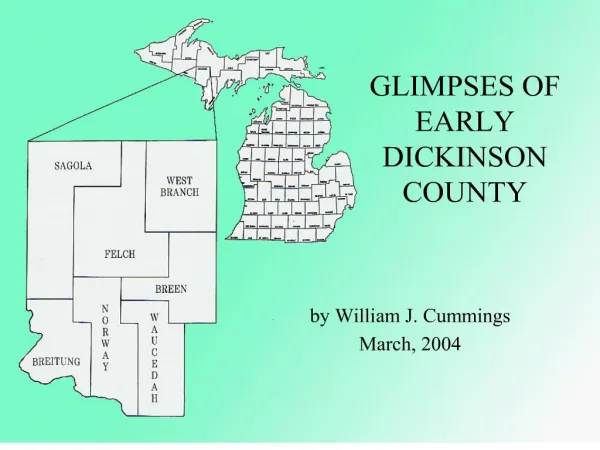
GLIMPSES OF EARLY DICKINSON COUNTY. by William J. Cummings March, 2004. Evolution of Michigan from Northwest Territory to Statehood.

E N D
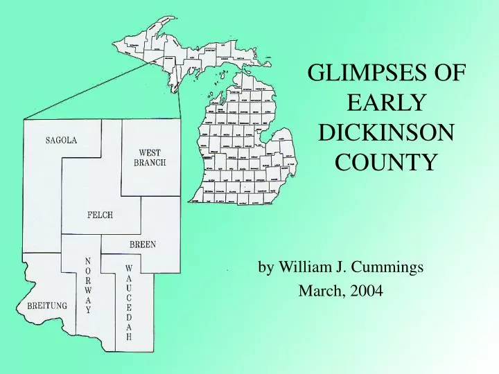
GLIMPSES OF EARLY DICKINSON COUNTY by William J. Cummings March, 2004
Evolution of Michigan from Northwest Territory to Statehood From 1787 to 1800 the lands now comprising Michigan were a part of the Northwest Territory. From 1800 to 1803 half of what is now the Lower Peninsula of Michigan and all of the Upper Peninsula were part of Indiana Territory. From 1803 to 1805 what is now Michigan was again part of the Northwest Territory which was smaller due to Ohio achieving statehood on March 1, 1803. From 1805 to 1836 Michigan Territory consisted of the Lower Peninsula and a small portion of the eastern Upper Peninsula. In 1836 the lands comprising the remainder of the Upper Peninsula were given to Michigan in exchange for the Toledo Strip.
Michigan Territory Map, 1822 This map of Michigan Territory appeared in A Complete Historical, Chronological and Geographical American Atlas published by H.S. Carey and I. Lea in Philadelphia in 1822. Note the lack of detail in the northern Lower Peninsula and the Upper Peninsula which were largely unexplored and inhabited by Native Americans at this time.
EXTRA! EXTRA!READ ALL ABOUT IT! VULCAN – A number of Indians – men, women and children – came into town Wednesday last from Bad Water [sic] for the purpose of selling berries, furs, etc., having with them a lot of regular Indian ponies. They make a novel picture as they go along one after the other, looking more like Indians we read about than those usually seen in civilization, and are always looked upon in wonderment by strangers, though it has long since lost its novelty to the residents here. –The Menominee Ranger The Iron Port, Escanaba, Mich. August 9, 1879
Tom King Tom “Wildcat” King (1830-1910) Mrs. Tom (Josephine) King
EXTRA! EXTRA!READ ALL ABOUT IT! RANGE ITEMS. --The Chippewas, 300 strong, held their annual pow-wow at Chicagoan [sic] lake last week. – Menominee Range. The Iron Port, Escanaba, Delta County, Mich. June 9, 1883
Menominee Joe and Jerome Dakota Menominee Joe (left) and Jerome Dakota, Indians from the Badwater Indian village, paddled their birchbark canoe near Eagle Island in the Spread Eagle Chain of Lakes, Wisconsin, during the summer of 1896. The canoe is similar to birchbark canoes sold by the Badwater Indians at a cost of one dollar per foot.
EXTRA! EXTRA!READ ALL ABOUT IT! SAGOLA NEWS GOSSIP Edw. Ryan is putting up a new building at Randville on the Tom King property, which he recently purchased. The building is 24 x 53 feet in size and will be divided into two store rooms, one to be a grocery store and the other a saloon. Iron Mountain Press, Iron Mountain, Dickinson Co., Mich. Thursday, June 25, 1908
Badwater Burial Ground Edwin Trestrail, son of William C. Trestrail, posed by an Indian grave at the burial ground at Badwater near the Big Bend of the Menominee River in about 1922-1923. William C. Trestrail acquired the property February 19, 1912, and named it Riverview Farm. Edwin J. Trestrail acquired the property from his father May 25, 1925. When the Ford Dam was built this land was flooded by the backwater.
James S. Dickey James S. (pictured here) and William Dickey, among Dickinson County’s earliest pioneers, established their trading post on Section 34, Town 40 North of Range 30 West (northeast of Quinnesec) in about 1871, trading with the Indians and providing basic supplies to early explorers. Almost all contemporary accounts mention stopping at Dickey’s on the old State Road until about 1880, when the Dickey brothers pursued other occupations. William Dickey settled in Norway in 1880, where he established a livery stable and blacksmith shop. By April, 1885, William Dickey had a livery stable in Marinette, Wisconsin, and James S. Dickey was farming in the Iron River area. The Dickey brothers later moved out West.
George Frederick Seibert Arrived at Dickey’s at 6:30 [p.m.] and was not favorably impressed by the outside appearance, but found myself mistaken in my estimate of the place. We got a splendid supper and found a very pleasant woman in Mrs. Dickey...Had a smoke and was standing in the store...when two Redmen came in and commenced talking with the Dickeys. The only thing I understood was “kee win” (no friend). The Dickeys being traders and buyers of furs spoke the Indian dialect fluently, and kept up a conversation for over half an hour with them. The Indians took some crackers and drank some -- gin, I think it was, and then made as they would go, but they hung around for a long time even after we went to bed. The Dickeys, I think, are very nice people, but I don’t think they would scruple at anything to make money. The selling of liquor to Indians is punished severely, but they did it. They have furs of all kinds in their store, fisher, otter, beaver, lynx, mink, fox, etc. They keep overalls, cigars, tobacco, pipes, whisky, prints, and groceries. Store is small, but large enough to do all their trading with the Reds. George Frederick Seibert, pioneer Iron Mountain druggist, recorded his stop at Dickey’s Trading Post in his journal during a trip up the Menominee River in 1879. His entry for May 6th, Sunday morning, read in part:
EXTRA! EXTRA!READ ALL ABOUT IT! The contract for building the Extension to the Menominee iron range has been let by the C. & N.W.R.R. Co., to Featherly & Farnsworth of Green Bay. They are to commence work immediately. The Escanaba Tribune, Escanaba, Delta County, Mich. February 22, 1873 P.M. Brown is clearing away a lot at section 42, or Power’s Station, for the purpose of erecting a hotel. The junction of the Menominee Range Road will be there. The Escanaba Tribune, Escanaba, Delta County, Mich. March 15, 1873
EXTRA! EXTRA!READ ALL ABOUT IT! About 150 men at work on the Menominee Range railroad struck for higher wages last Tuesday, and after proceeding to “42” met some 60 laborers who had just come in on the train from the south. These gave such an unfavorable account of matters outside, that the most of the men went back to work again at the same wages. They were getting $1.25 a day and were paying $3.50 for board but wished their wages were raised to $1.50, a demand which was not complied with. The Escanaba Tribune, Escanaba, Mich. April 21, 1877
Railroad Gang, ca. 1877 Possibly the Menominee River Railroad Gang, ca. 1877
One Hundred Men Wanted Contractor D.L. Wells placed this advertisement in the October 20, 1877, edition of The Iron Port, as the building of the Menominee River Railroad continued westward, opening up the Menominee Iron Range.
Menominee Iron Range Map The Menominee Iron Range spanned about 60 miles, extending from Waucedah on the east to Iron River on the west. J.F. Hanst’s map appeared in Volume XXI of the Lake Superior Mining Institute Proceedings (1916-1917) and located mines then in operation. The Chicago & North-Western Railroad branch line traveling northwest from Powers in Menominee County connected the mines with Escanaba, a Lake Michigan iron port.
Chapin Mine, Iron Mountain, Spring, 1880 From 1787 Between 1880 and 1932, the Chapin shipped 27,506,868 tons of iron ore, accounting for fully one-third of Dickinson County’s entire iron ore production. While the Chapin maintained its title as the Menominee Range’s leading producer, only Ironwood’s Norrie-Aurora-Pabst Mine on the Gogebic Range, shipping over 53,802,000 tons from 1885 to 1935, surpassed the Chapin’s production in the Upper Peninsula.
Chapin Mine, Iron Mountain, 1880 Another early view of the Chapin Mine, also supposedly dating to 1880, shows considerable growth. A more substantial shaft housing has been erected, and many new mining buildings appear in the background.
Miner’s Strike Handbill When Iron Mountain was scarcely four years old, the first miners’ strike on the Menominee Iron Range occurred after the management of the Chapin and Ludington mines posted an order requiring miners to work an additional five hours on Saturday evening, instead of finishing the work week at 6 p.m. According to Superintendent C.H. Cady of the Chapin Mine, the issue at stake was an order issued from his office requiring the men to work the number of hours each day that they were paid for. The men had been in the habit of coming out of the mine long enough before the whistle blew at noon to change their clothes, and not coming back to prepare for going into the mine until 1 o’clock, thus using an hour or more of time belonging to the company for purposes of their own. This order also required them to work from 6 till 11 o’clock p.m. Saturdays. The men refused to comply with the order, and by their action closed the mine. The owners intended to operate the mine that winter solely for the purpose of furnishing the men employment and enabling them to support their families. Cady wanted them to pay the consequences for stopping work at the mine..
Ludington Mine Officials These mining officials from Iron Mountain’s Ludington Mine posed for H.S. Emory, an Appleton, Wis., photographer, sometime between 1883 and 1890. They are identified as follows: (back row) William B. Catlin, surface boss; Robert Bankes, cashier and later superintendent; A.D. Moore, superintendent; Harry McDermott, master mechanic; Francis A. Brown, chief chemist; Sam Spear, bookkeeper; (front row) Captain Grey; Captain Sam Langdon; Captain Henry Shields; Morris Danielson, blacksmith; Tom Hancock, carpenter.
200 Block Stephenson Avenue, Jenkins Hotel In this view the camera is facing north on Stephenson Avenue in the mid-1880’s, about the time of the Miners’ Strike. The view shows the east side of the 200 block, where the First National Bank is now located. William H. Jenkins opened his hotel at the corner of South Stephenson Avenue and East Ludington Street in early November, 1881. The three-story frame hotel was considered among the city’s finest, rooms renting for $2.00 per day in 1885. The fourth building from the corner, advertising dry goods and clothing, was probably Charles E. Parent’s store, one of the first in the village.
300 Block Stephenson Avenue, Schuldes & C. Taken in the last half of the 1880’s, this photograph, looking south, shows buildings on the east side of the 300 block of South Stephenson Avenue. The sign on the first building on the left, located at the southeast corner of the intersection with East Ludington Street, reads City Hotel. A small sign between this building and the next advertises a dressmaker. The second store, at 305 South Stephenson Avenue, was a general store operated by Charles Schuldes and Emil Carriere between 1885 and 1889. Their advertising banner stretches across the street. The tall pine at the right stands where the intersection with East A Street would be today, and beyond is forest and swamp.
Freezing of D Shaft, Chapin Mine, 1888 Engineer George Thomas, of the Poetsch Sooysmith Company, of New York, supervised the freezing process used to sink D shaft of the Chapin Mine through over 90 feet of rock and loose sand. The process began in the late fall of 1888, and, after 15 days of freezing, the excavation of the shaft began, reaching the ledge 135 days later. This historic photograph of the freezing process records what may have been the first such attempt in the United States. The shaft was sunk inside the circle of pipes in a cylinder of frozen ground measuring 50 feet in diameter. In the background, the air pipe carrying compressed air from the Hydraulic Power Company at the Upper Quinnesec Falls to the Chapin and Ludington mines to run machinery towered over the buildings.
Diagram of Cornish Pumping Engine, ca.1892 Designed by Edwin Reynolds of the Edward P. Allis & Company, in Milwaukee, Iron Mountain’s Cornish pumping engine was first started on Tuesday, January 3, 1893 at 2:20 p.m. A few months later President Grover Cleveland pressed the button which started the 3,000 horsepower horizontal quadruple-expansion Reynolds-Corliss engine on exhibit at the 1893 World’s Columbian Exposition in Chicago. This engine, “Pride of Machinery Hall,” had a flywheel 30 feet in diameter [10 feet less than his Iron Mountain engine] which drove two Westinghouse 750 kilowatt alternators supplying the current for 20,000 16-candlepower incandescent lamps throughout the fairgrounds in Chicago. Reynolds received national and worldwide recognition for his outstanding achievements in engine design and construction.
Original Building Housing Cornish Pumping Engine This view of the Chapin Mine’s D shaft complex, looking east, was probably taken between 1893 and 1896. Two tramways exit the shaft housing’s mid-point. A steam locomotive appears to be pushing four cars directly below, in front of the vast stockpiles. To the right of the sandstone engine house and across the street, on North Stephenson Avenue, some of the Chapin Mining Company’s shops are visible. The Millie Mine, originally the Hewitt, can faintly be seen directly above and slightly to the left of the shaft housing near the crest of Millie Hill, with Pewabic Hill rising in the background. The Hydraulic Power Company’s air pipe appears at the lower right, extending west to the Ludington shaft and northwest to the Hamilton shaft.
C Ludington Shaft, 1912 Dated October 19, 1912, this view of the C Ludington shaft, facing east, shows the shaft housing which rose 114 feet above the collar. The chutes to the left allowed ore cars, like those pictured, to be loaded directly, as the ore came up in the tram cars on the hoist. The cage in which the men descended and ascended can be seen at the lower left of the shaft housing. The pump house, covering the Cornish pumping engine where it still stands today, was sheathed in corrugated metal and rested on a red sandstone foundation. A pipe can be seen leading from the boiler house to the pump house, feeding steam to the gigantic engine. Another railroad track passed between these two buildings.
Cornish Pumping Engine Interior CORNISH PUMPING ENGINE STATISTICS Engine Height……...54 Feet Above Floor Engine Length……..75 Feet from Back of Flywheel to End of Pump Bob Engine Weight………………….725 Tons High Pressure Cylinder……...50 Inches in Diameter High Pressure Head……………...10 Tons Low Pressure Cylinder…….100 Inches in Diameter Low Pressure Cylinder Head…….17 Tons Stroke of Pistons………………….10 Feet Flywheel....40 Feet in Diameter; 160 Tons Flywheel Rim...24 Inches Thick and Wide Cost of Engine Alone…………....$82,500
Pewabic Mine, 1887 Iron Mountain’s Pewabic Mine, located east of Millie Hill on Pewabic Hill, opened in 1887. This photograph was taken shortly thereafter and facing north, shows the extensive tramway leading from the early wooden shaft. Several ore cars have passed under the tramway and have been loaded from the ore pocket. The men standing in front of the ore cars nearest the tramway help provide a visual scale by which to measure these immense mining structures. Judging from the logs to the left of the picture, the mine’s sawmill must have been located to the left of the shaft.
Pewabic Mine Accident Survivors, 1894 Of the survivors of the October 25, 1894, Pewabic Mine accident, only two men in the back row have been positively identified. They are William Beard, at the extreme left, and Peter Hallberg, third from left. The names of the remaining men are Stephen Allen, John Forrell, Samuel Husband, George Marcous, William Oliver, Thomas Penglase, George Rickard, John Thomas and George Wilcox.
William A. Holmes & Son Logging Crew, ca.1885 A William A. Holmes & Son logging crew has just finished loading a narrow gauge railway car, probably somewhere east of the Michigamme River in the mid-1880’s. William A. Holmes is standing fourth from the left in front of the carload of logs. Tom King, a Chippewa Indian who lived in and around Dickinson County for many years, is seated on the log, holding his hat against his leg with his left hand. The lumberjack behind King with his foot resting on the log and a cant hook over his left shoulder is Patrick “Paddy” Costigan.
William A. Holmes & Son Logging Crew, 1886 In 1886, William A. Holmes & Son were logging just across what became the Dickinson County line in Section 26 of Township 43 North, Range 31 West. Section 36 is located east of the Michigamme River, an area in which Holmes & Son logged extensively between 1881 and 1893. Notice the primitive narrow gauge steam engine, a 9-ton wood burner, which was used to pull carloads of pine logs.
EXTRA! EXTRA!READ ALL ABOUT IT! RANGE ITEMS. --K.S. Buck shot at a lynx from his seat in a cutter. The shot scared his horse and in pulling on the lines he discharged his pistol (self-cocking) and killed the horse. -Range. The Iron Port, Escanaba, Mich. April 11, 1885
Cook Shanty Interior, Camp Three, Breen Township, ca. 1915 Substantial, well-cooked meals were essential to the lumberjacks, who worked long, hard hours outdoors in all kinds of weather. This logging crew paused before their meal in the cook shanty of Camp Three in Breen Township sometime during the mid-teens. Tin cups placed upside down upon tin plates in the same position marked each setting at the sawbuck table. Graniteware coffeepots filled with the preferred beverage were also in readiness. The cook at the left sat on a part of a primitive sink needed to wash all the dirty tableware after each meal. Note the pole rafters supporting the rough-sawn boards above.
Jauquet Brothers Logging Camp, February, 1905 The crew at the Jauquet Brothers logging camp, pictured here in February, 1905, posed in front of the bunkhouse located in Section 24, Township 43 North of Range 30 West in Sagola Township. The first man at the left in the front row was David Curtis. The Jauquet brothers (Frank, Hubert, Clem and John) and their sister Mary, holding her son, were also sitting in the front row.
Jauquet Brothers Sprinkler Sled Sprinkler sleds like this one at the Jauquet Brothers logging camp in Sagola Township were used to make ice roads to facilitate hauling loads of logs.
Mill Company Log Marks The above chart appears on page 55 of Logs on the Menominee: The History of the Menominee River Boom Company by Fred C. Burke. This book was published in Marinette, Wisconsin, in 1946. The chart shows a few of the nicknames, side marks, end marks and catch marks used in logging on the Menominee River. Lumberjacks used stamping hammers to mark the logs which were floated down the river during the spring drive and then sorted out by company at the boom company so payment could be accurately made.
Log Drive Camp on the Menominee River, ca. 1890 Taken near Hydraulic Falls in about 1890, this photograph shows a typical log drive camp. Note the cook tent and the large kettles steaming over open fires. At the right is the air pipe, 24 inches in diameter, which served the Chapin and Ludington mines with compressed air to work machinery, running nearly three miles from the Hydraulic Power Company to Iron Mountain. A favorite pasttime for several generations was “walking the pipe” to the falls and back.
Log Jam on Menominee River, 1899 Maude Gee (standing) and Jamie Gee, Jeffie Whitehead and John Bush posed for the photographer on a huge log jam near either the Upper or Lower Quinnesec Falls of the Menominee River on April 23, 1889. Log jams were common during the spring drive, and getting the logs moving again was dangerous and tested the lumberjacks’ skills with a peavy, cant hook and balance. A short article in the April 14, 1892 edition of The Iron Range, an Iron Mountain newspaper noted: SCORES of people have visited Quinnesec falls the past week to see the immense log jam there, which extended from the Hydraulic works to within a short distance of the railroad bridge. A force of men were employed blasting the ice and breaking the jam, and succeeded in starting the logs last Tuesday. It is estimated that there were 6,000,000 feet in the jam.
EXTRA! EXTRA!READ ALL ABOUT IT! Since 1868 to the present time (1916) there has been a gradual falling off in the number of feet banked on the river and in size of the logs. There have been spurts, when years were greater than previous ones, but on the whole there has been a gradual falling off. Including the season just closed and from 1868 there have been 10,794,749,178 feet of timber sent down the Menominee river. The largest year was in 1889 when 642,138,318 feet were floated. The smallest year was in 1914, the total being 22,734,190 feet. Last year there was a sudden spurt over 1914, 23,474,222 feet having been banked. The passing of the large timber is also seen in the figures of the Boom company. For instance, in 1888, the average log which came down the river had 192 feet of lumber in it. The average in 1913 and 1915 was but thirty-eight feet. Iron Mountain Press, Iron Mountain, Mich. Thursday, January 13, 1916
Map Dickinson County Formation When the Michigan Legislature established Dickinson County on May 21, 1891, six townships were taken from Marquette County to form the northern and a portion of the eastern border. A rectangle of six townships adjoining those taken from Marquette County were taken from Iron County to form the remainder of the northwest portion of the county. The southern half of the county was taken from Menominee County. Dickinson County is Michigan’s youngest county.
Donald M. Dickinson Donald McDonald Dickinson, the man for whom Dickinson County was named, was the second Michigan Democrat -- the first being Lewis Cass -- to rise to a position of national political importance. He had a close and enduring political and personal friendship with President Grover Cleveland, who requested Dickinson accept the position of postmaster-general of Michigan in 1888. Dickinson served until the close of the Cleveland administration in 1889. Born in New York, Dickinson was raised in Michigan, attending school in Detroit and graduating from the University of Michigan Law School in 1867. He gained a reputation of being one of the leading lawyers of the Midwest and was frequently called upon to argue cases before the Supreme Court of the United States. From 1787 Donald M. Dickinson (1846-1917)
Breen Township Breen Township Organized March 16, 1867 Part of Menominee County SETTLEMENTS Calumet Mine, 1882 Foster City, 1884 Hardwood, 1884 Hylas, C&NW R.R. Station Spruce, C&NW R.R. Station
Bartley Breen Bartley and Thomas Breen, brothers for whom Breen Township was named, were born in New Brunswick, Canada. As children they moved with their parents to Menominee, Michigan, their father arriving in 1849 and their mother and the children arriving the following year. The brothers worked as timber cruisers before enlisting in the Civil War. Following the war they resumed their occupation and in 1866 discovered an outcropping of iron ore which became the Breen Mine, located in Waucedah. In 1872 the Breen Mining Company was incorporated with a capital stock of $500,000. The mine was situated on 120 acres of land. Thomas retired from timber cruising and exploring for iron ore in 1886, never married, and was still living in Menominee in 1920. Bartley defeated Joseph Fleshiem for a seat in the Michigan House of Representatives in the fall of 1886, serving one term (1887-1888). He moved his family to Chicago in about 1892, and died there in November, 1901. Bartley Breen (1834-1901)
EXTRA! EXTRA!READ ALL ABOUT IT! A new station called Foster City has been opened on the Peninsula division of the C. & N.W. railroad. It is located about five miles from Metropolitan. The Current, Norway, Menominee County, Mich. Saturday, November 7, 1885
Foster City - Morgan Cedar & Lumber Co., 1905 Morgan Lumber and Cedar Company Sawmill, Foster City, ca. 1905
Foster City - Morgan Cedar & Lumber Co., 1910 Taken in about 1910 across the millpond, this overall view shows Foster City’s Morgan Lumber and Cedar Company’s sawmill complex. The white building just to the left of center bearing the company’s name was the company store. The sawmill itself, complete with its cone-shaped sawdust burner, is at the right. The superintendent lived in the large residence directly above the company store, while the boardinghouse to the right housed many employees.
Foster City, Morgan Lumber Company Store, ca. 1910 Morgan Lumber & Cedar Company Store, Foster City, ca. 1910
Foster City, Morgan Co. Store Meat Market, 1914 The calendar reads April, 1914, in this photograph showing the meat market of the Company store in Foster City. Joe Kelly, the butcher, stands behind the counter near the scale. Note the hams hanging at the left and the spool of string hanging above the counter ready to secure packages wrapped in butcher paper.