Download
1 / 6
80 likes | 808 Views
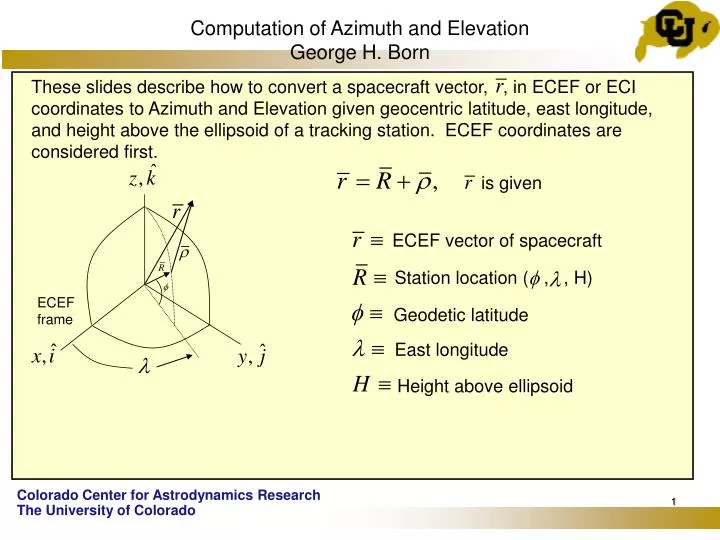
Computation of Azimuth and Elevation George H. Born.

E N D
Computation of Azimuth and ElevationGeorge H. Born These slides describe how to convert a spacecraft vector, , in ECEF or ECI coordinates to Azimuth and Elevation given geocentric latitude, east longitude, and height above the ellipsoid of a tracking station. ECEF coordinates are considered first. is given ECEF vector of spacecraft Station location ( , , H) ECEF frame Geodetic latitude East longitude Height above ellipsoid
Computation of Azimuth and Elevation 1) Compute in the ECEF ( , , ) frame and are the equatorial radius and flattening respectively of the reference ellipsoid
Computationof Azimuth and Elevation 2) Compute in ECEF coordinates 3) Now convert to coordinates To get replace with the coordinates of .
Computation of Azimuth and Elevation 4) Compute Azimuth, , and Elevation, .
Computation of Azimuth and Elevation • If the spacecraft vector is given in J2000 ECI coordinates (X, Y, Z) it is necessary to transform it into the ECEF frame. To be accurate this involves a series of five rotations to account for equatorial precession, nutation, Earth rotation, and polar motion. However, a close approximation can be obtained by only accounting for Earth rotation. This can be accomplished by computing the Greenwich sidereal time, , given by • where is the rotation rate of the Earth, 0.72921158553 x 10⁻⁴ rad/sec, is the angle between the ECI X-axis and the prime meridian measured in the equatorial plane, and is the value of at the reference time, . The spacecraft vector in the ECEF frame is given by Now proceed with step 1. Then
Computation of Azimuth and Elevation The value of at any UTC can be obtained by inserting a satellite into a scenario in STK. Set the orbit epoch and start time to the desired UTC, set the longitude of the ascending node to 0.0° and click the apply button. Then choose right ascention of the ascending node (RAAN). This will be the value of for the chosen time. Of course, one can also compute the Azimuth and Elevation in STK. For example, at universal time coordinated, UTC, JAN 1, 2008, 0 h, 0 m, 0 sec, . • References: • Bate, Muller, and White, Fundamental of Astrodynamics, Dover, 1971, • Chapter 2. • Curtis, H. D., Orbital Mechanics for Engineering Students, Elsevier, 2005, • Chapter 5.5.