Download
1 / 26
260 likes | 418 Views
Alos optical data processing. End of Stage Presentation. Trainee: ARNAL Etienne etienne.arnal@isen.fr Tutor: Mr COLIN Olivier olivier.colin@esa.int. Presentation Outline. Alos Product Descriptor (PRISM and AVNIR2) Alos Image Processing (PRISM and AVNIR2) Digital Elevation Model

E N D
Alos optical data processing End of Stage Presentation Trainee: ARNAL Etienne etienne.arnal@isen.fr Tutor: Mr COLIN Olivier olivier.colin@esa.int
Presentation Outline • Alos Product Descriptor (PRISM and AVNIR2) • Alos Image Processing (PRISM and AVNIR2) • Digital Elevation Model • 3D results ESRIN - ARNAL Etienne
Data Image DEM 3D results Alos Product Descriptor (1/5) • Realisation of a cqfd dictionary containing the fields of the Product Format Description of Prism and Avnir2. • Allows to find quickly all fields of level: 1A = raw data extracted from the Level 0, 1B1 = with radiometric corrections, 1B2R = geo-referenced, 1B2G = geo-coded. ESRIN - ARNAL Etienne
Data Image DEM 3D results Alos Product Descriptor (2/5) • CQFD: binary data reader. FILE ; |_ VOL ; | |_ VolumeDescriptor ; | |_ FilePointer ; (3 to 9) | |_TextRecord ; |_ LED ; | |_ CommonFileDescriptor ; | |_ FileDescriptor ; | |_ SceneHeader ; | |_ Ancillary1 ; | |_ Ancillary2 ; | |_ Ancillary3 ; in the data ESRIN - ARNAL Etienne
Data Image DEM 3D results Alos Product Descriptor (3/5) • CQFD: binary data reader. |_ IMG ; | |_ IMG1 ; (1 to 6) | | |_ CommonFileDescriptor ; | | |_ FileDescriptor ; | | |_ Line 1 ; | | |_ … | | |_ Line n ; |_ TRL ; | |_ CommonFileDescriptor ; | |_ FileDescriptor ; | |_ Trailer ; |_ SUP ; | |_ CommonFileDescriptor ; | |_ FileDescriptor ; | |_ Ancillary ; in the data ESRIN - ARNAL Etienne
Data Image DEM 3D results Alos Product Descriptor (4/5) • CQFD: binary data reader. |_ TiePoints ; | |_ Line 1 ; | | |_ Lat ; | | |_ Long ; | |_ … | |_ Line n ; in the data (I,J) are pixel and line of corrected image (φ,λ) are degrees of latitude and longitude ESRIN - ARNAL Etienne
Data Image DEM 3D results Alos Product Descriptor (5/5) • Thanks to this CQFD dictionary, everybody can find a precise field in every Prism and Avnir2 data. • The next step is to create image. ESRIN - ARNAL Etienne
Data Image DEM 3D results Alos Image Processing (1/5) 3 various image data structure: • Several CCD (Prism 1A, 1B1) From 3 to 6 CCD CCD = ~4992 pixels * 16000 lines Overlap = 32 pixels • One CCD (Prism 1B2R, 1B2G) CCD = ~15000 pixels * 14000 lines • 4 Spectral Bands (Avnir2) Band = ~7150 pixels * 8000 lines ESRIN - ARNAL Etienne
Data Image DEM 3D results Alos Image Processing (2/5) • Imager: data reader for image generation For each pixel: • elaborates from the band values (0 to 255) applying sun angle correction and stretching to enhance image contrast, • extracts Tie Point (λ,φ) grid. It creates: one image file (including all CCD/Bands), one GeoTiff file (geolocalisation). ESRIN - ARNAL Etienne
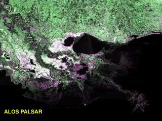
Data Image DEM 3D results Alos Image Processing (3/5) • Prism Nadir 1B2R Shizuoka, Japan on February 14, 2006 ESRIN - ARNAL Etienne
Data Image DEM 3D results Alos Image Processing (4/5) • Avnir2 Tanegashima Is., Japan on February 17, 2006 ESRIN - ARNAL Etienne
Data Image DEM 3D results Alos Image Processing (5/5) • encountered problems Avnir2, ±5 pixels between each columns. Prism and Avnir2, geolocalisation error. Prism, many artifacts. Prism and Avnir 1B2(R/G), nothing about time in the data. ESRIN - ARNAL Etienne
Data Image DEM 3D results Digital Elevation Model (1/10) • Stereoscopy 3D, imager process. • For each pixel [I,J], Find the value of pixel Nadir [I,J] and [λ,φ]=fN(I,J) Find the value of pixel Backward fB-1[λ,φ] Find the value of pixel Forward fF-1[λ,φ] • Output: one RGB image with R=Nadir, G=Forward and B=Backward. ESRIN - ARNAL Etienne
Data Image DEM 3D results Digital Elevation Model (2/10) • DEM, bases Height is proportional to the along track displacement. Nadir Satellite track Forward ESRIN - ARNAL Etienne
Data Image DEM 3D results Digital Elevation Model (3/10) • DEM, base equation ∆ is a multiple of the ground resolution ESRIN - ARNAL Etienne
Data Image DEM 3D results Digital Elevation Model (4/10) • DEM Algorithm. • Image adjustments Forward Nadir Backward Mean = 35 STD = 3.4398 Mean = 43 STD = 2.4389 Mean = 57 STD = 2.5302 ESRIN - ARNAL Etienne
Data Image DEM 3D results Digital Elevation Model (5/10) • DEM Algorithm. • Image adjustments, • Generate pyramid image, with gradually degraded resolution. Pass the matched points to the higher resolution level for fine matching. ESRIN - ARNAL Etienne
Data Image DEM 3D results Digital Elevation Model (6/10) • DEM Algorithm. • Image rectification, • Generate pyramid image, • Feature matching, ESRIN - ARNAL Etienne
Data Image DEM 3D results Digital Elevation Model (7/10) • DEM Algorithm. • Image rectification, • Generate pyramid image, • Feature matching, • Matching results, 1/16 1/8 1/4 1/1 1/2 ESRIN - ARNAL Etienne
Data Image DEM 3D results Digital Elevation Model (8/10) • DEM Algorithm. • Image rectification, • Generate pyramid image, • Feature matching, • Matching results, • Filtering. Median filter, reduce noise (peaks): Mean filter, reduce high frequencies: ESRIN - ARNAL Etienne
Data Image DEM 3D results Digital Elevation Model (9/10) • Integration in eogrid.esrin.esa.int. • Modification for Linux (no graphics), • Installation of Matlab Component Runtime, • Compilation of Matlab code (Stand-alone application). • Integrated new “DEM” application in G-POD in < 1 day ESRIN - ARNAL Etienne
Data Image DEM 3D results Digital Elevation Model (10/10) • encountered problems • Co-registration is corrected manually due to ALOS processors geo-referencing problem • Result of matching requires validation of the correlation distribution not trivial • Correlation is impaired by high height gradients in image (e.g. buildings) possible solution to weight the matching window with distance to centre • Patterns oriented along-track have low correlation contrast • Moving objects (cars, boats, troy horses, etc) • Sun glint creates big differences between views • Image radiometric quality (e.g. striping, spurious saturation artifacts) • Image boundaries ESRIN - ARNAL Etienne
Data Image DEM 3D results 3D results • Japan, Shizuoka and surroundings, 02/14/2006. • AATSR Hurricane Jeanne, 20/09/2004 • Stereoscopic views. • Digital Elevation models. ESRIN - ARNAL Etienne
Potential Enhancements • Investigate alternative matching methods for high gradient terrains (e.g. parallax, urban areas) • Make adaptive algorithm e.g. apply dynamically different techniques/parameters depending on correlation contrast observed • Integrate automatic co-registration of the 3 views with a good geo-referencing. • Add possibility to correlate several bands in parallel (e.g. AATSR dual views with 4 channels) • Include DEM geo-coding in last stage • Optimize algorithm for performance in multi-processing environment (e.g. tiling) • Calibration & Validation ! ESRIN - ARNAL Etienne
Data Image DEM 3D results Thanks • Olivier Colin, • Jerome Louis, • Philippe Goryl, • Peter Reinartz (DLR), • Nityaporn Sirikan, • Patrick Grimont, • Emmanuel Mathot. Questions ? ESRIN - ARNAL Etienne