Download
1 / 18
360 likes | 1.44k Views
Polynesian Navigation. Astro 6 “Archeoastronomy and World Cosmology” December 15, 2000 David Chen submitted to Professor Bryan Penprase. Map of Polynesia. Surface area greater than the continent of Europe. Farthest distances between islands over 2000 miles.

E N D
Polynesian Navigation Astro 6 “Archeoastronomy and World Cosmology” December 15, 2000 David Chen submitted to Professor Bryan Penprase
Map of Polynesia • Surface area greater than the continent of Europe. • Farthest distances between islands over 2000 miles. • All of Polynesia settled by 400 A.D. • All Polynesian cultures share linguistic, cultural, and agricultural roots.
Europe’s First Impression • “Many found the notion of deliberate voyages so unrealistic that they thought there must have been chains of islands or a lost continent connecting the farther islands in former times.” (Sharp 51) Captain James Cook, first European to visit Polynesia
Europe’s First Impression • How could Polynesians have settled such widely distant islands when “western Europeans with their extended coast-line did not get even to the nearest islands until the days of large sailing ships and instruments.” (Sharp 46) A sextant: a necessary navigation instrument for European sailors
Polynesian Commonalties • Cook found commonalties in all the inhabited islands he visited: • common linguistic heritage • common navigation techniques • common staple crops • common religious ritual • common cosmology
Navigators • Polynesian Master Navigators lacked mechanical instruments to guide their voyages, they were guided by: • Astronomy • Winds and waves • Accumulated knowledge and experience of forebears
Wayfinding • Wayfinding is the art of navigation without instrumentation. It involves an intimate knowledge of the sky, the ocean, and weather.
Wayfinding Chad Baydayan [master navigator] distinguishes wayfinding from navigation - the technical art of finding land without the use of instruments or charts. He will tell you that wayfinding is "a way of organizing the world." He has also said that it's "a way of leading," "of finding a vision," "a set of values," "how to take care of the earth," and, in general, "a model for living my life.” (PVS)
Wayfinding • “To hold a course, the navigator aligns the rising or setting sun to marks on the railings of the canoe. There are 8 marks on each side of the canoe, each paired with a single point at the stern of the canoe, giving bearings in two directions, 32 bearings in all to match the 32 directional houses of the Hawaiian star compass.” (PVC)
Polynesian Star Compass Noted Heliacal Risings: Cassiopeia Big Dipper Capella Deneb Vega Castor Arcturus Aldebaran Altair Betelguese Procyon Rigel Spica Sirrius Antares Canopus Alpha and Beta Centauri Acrux …and solsticial sunrises and sunsets.
Southern Cross "The Southern Cross is really important to us. It looks like a kite. These two stars in the Southern Cross always point south (Gacrux on top and Acrux on the bottom). If you are traveling in a canoe and going south, these southern stars are going to appear to be traveling the higher and higher in the sky each night. If you went down to the South Pole, these stars are going to be way overhead. If you are going north to Hawai'i, the Southern Cross travels across the sky in a lower and lower arc each night. When you are at the latitude of Hawai'i, the distance from the top star (Gacrux) to the bottom star (Acrux) is the same distance from that bottom star to the horizon. That only occurs in the latitude of Hawai'i.” (PVC)
Timekeeping “...the Hawaiians used a calendar based on the moon, knew and corrected its error by reference to the stars, named each month, and each night of the month by the characteristics of the moon, and judged the hour closely by the stars at night, or the sun by day.” (PVC)
Ritual Cosmology • A priestly astrologer, the kilo hoku would give the more important of the prospective trips a good clearance, or hold the boat for a better day; and mixed with his rites there were always the realties of keen weather observing. Of course the pig must be baked, the 'awa chewed and mixed, the gods propitiated with offerings and prayers, and then the heavens and sea scanned for portents. If the rainbow stood arched in the wrong quarter, if the clouds were flying in scattered fragments, the wind and sea from the wrong direction, the sailing was delayed. But if the indications were fair the astrologer completed the prognosis with an inspired dream, and the voyage was well begun. (PVC)
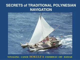
Canoe Construction • Hokule'a - modern replica of ancient canoe • double hulled • triangular sails • hull carved from whole logs • sails weaved from flax or pandanus matting
Canoe Construction • Petroglyph of canoe, found on Easter Island. • The double-hull design was popular throughout Polynesia.
Conclusion Polynesians were master navigators whose deep understanding of the sky was intricately connected to values of exploration, vision, and harmonious living. Their extraordinary accomplishments stand as a testament to the power of the human mind and spirit. 0 na hoku no na kiu o ka lani . "The stars are the eyes of heaven."
For more information... Polynesian Voyaging Society- http://leahi.kcc.hawaii.edu/org/pvs/ Sharp, Andrew. Ancient Voyagers in the Pacific. Penguin Books. London: 1957. Gladwin, Thomas. East Is a Big Bird. Harvard University Press. Cambridge, Massachussetts: 1970.


![READ [PDF] The POLYNESIAN TATTOO Handbook Vol.2: An in-depth study of Polynesian tattoos](https://cdn7.slideserve.com/12541832/slide1-dt.jpg)