Download
1 / 1
10 likes | 152 Views
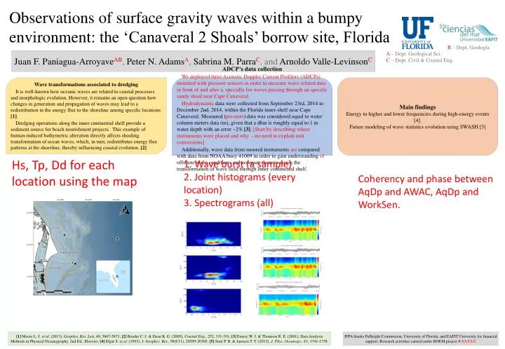
Observations of surface gravity waves within a bumpy environment: the ‘Canaveral 2 Shoals’ borrow site, Florida. B – Dept. Geología. A – Dept. Geological Sci. C – Dept. Civil & Coastal Eng.

E N D
Observations of surface gravity waves within a bumpy environment: the ‘Canaveral 2 Shoals’ borrow site, Florida B– Dept. Geología A– Dept. Geological Sci. C– Dept. Civil & Coastal Eng. Juan F. Paniagua-ArroyaveAB, Peter N. AdamsA, Sabrina M. ParraC, and ArnoldoValle-LevinsonC Main findings Energy to higher and lower frequencies during high-energy events [4]. Future modeling of wave statistics evolution using SWASH [5] Wave transformations associated to dredging It is well-known how oceanic waves are related to coastal processes and morphologic evolution. However, it remains an open question how changes in generation and propagation of waves may lead to a redistribution in the energy flux to the shoreline among specific locations [1]. Dredging operations along the inner continental shelf provide a sediment source for beach nourishment projects. This example of human-induced bathymetric alteration directly affects shoaling transformation of ocean waves, which, in turn, redistributes energy flux patterns at the shoreline, thereby influencing coastal evolution. [2] ADCP’s data collection We deployed three Acoustic Doppler Current Profilers (ADCPs) mounted with pressure sensors in order to measure wave-related data in front of and after a, specially for waves passing through an specific sandy shoal near Cape Canaveral. Hydrodynamicdata were collected from September 23rd, 2014 to December 2nd, 2014, within the Florida inner-shelf near Cape Canaveral. Measured (pressure) data was considered equal to water column meters data (m), given that a dbar is roughly equal to 1 m water depth with an error ~2% [3]. [Start by describing where instruments were placed and why - no need to explain unit conversions] Additionally, wave data from moored instruments are compared with data from NOAA buoy 41009 in order to gain understanding of offshore wave conditions and compare them to assess the transformation of wave field through inner continental shelf. Hs, Tp, Dd for each location using the map 1. Wave burst (a sample) 2. Joint histograms (every location) 3. Spectrograms (all) Coherency and phase between AqDp and AWAC, AqDp and WorkSen. [1] Moore L. J. et al. (2013), Geophys. Res. Lett, 40, 5867-5871; [2] Bender C. J. & Dean R. G. (2005), Coastal Eng., 252, 331-351; [3] Emery W. J. & Thomson R. E. (2001), Data Analysis Methods in Physical Oceanography, 2nd Ed., Elsevier; [4] Elgar S. et al. (1993), J. Geophys. Res., 98(C11), 20299-20305; [5] Smit P. B. & Janssen T. T. (2013), J. Phys. Oceanogr., 43, 1741-1758. JFPA thanks Fulbright Commission, University of Florida, and EAFIT University for financial support. Research activities carried under BOEM project # XXXXX