Download
1 / 24
270 likes | 739 Views
Earth Science 19.2 Pressure Centers and Wind . Pressure Centers and Wind . Pressure Centers . Pressure centers are among the most common features on any weather map.

E N D
Earth Science 19.2 Pressure Centers and Wind Pressure Centers and Wind
Pressure Centers • Pressure centers are among the most common features on any weather map. • By knowing just a few basic facts about centers of high and low pressure, you can increase your understanding of present and upcoming weather. • There are some general patterns associated with pressure zones: cloudy conditions and rain are usually associated with low pressure while sunny clear weather is associated with high pressure areas.
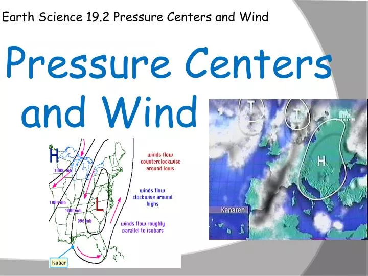
Highs and Lows • Lows, or cyclones, are centers of low pressure. • Highs , or anticyclones, are centers of high pressure. • In cyclones, lows, the pressure decreases from the outer isobars toward the center. • In anticyclones, highs, just the opposite is the case: the values of the isobars increasefrom the outside toward the center.
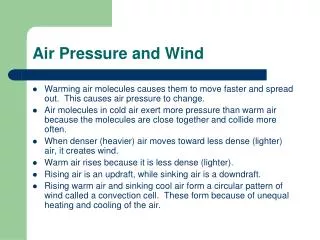
Cyclonic and Anticyclonic Winds • You learned that the two most significant factors that affect wind are the pressure gradient and the Coriolis effect. • Winds move from higher pressure to lower pressure areas and are deflected to the right or left by the Earth’s rotation. • When the pressure gradient and the Coriolis effect are applied to pressure centers in the Northern Hemisphere; winds blow counterclockwise around the low. Around a high, the winds blow clockwise.
Cyclonic and Anticyclonic Winds • In the Southern Hemisphere, the Coriolis effect deflects the winds to the left. • Therefore, the winds around a low, south of the equator, move clockwise while the winds around a high blow counterclockwise. • In either hemisphere, friction causes a net flow of air inward around a cyclone and a net flow of air outward around an anticyclone.
Weather and Pressure • Rising air is associated with cloud formation and precipitation, whereas sinking air produces clear skies. • Imagine a low pressure surface system where the air is spiraling inward. • Here the net inward movement of air causes the area occupied by the air to shrink; a process called horizontal convergence.
Weather and Pressure • When air converges(comes together) horizontally, it must increase in height to allow for the decreased area it now occupies. • This increase in height produces a heavier and taller column of air. • A surface low can exist only as long as the column of air above it exerts less pressure than does the air in the surrounding regions. This seems to be a paradox; a low-pressure center causes a net accumulation of air, which increases it’s pressure.
Cyclonic and Anticyclonic flow • In order for a surface low to exist for very long, converging air at the surface must be balanced by outflows aloft. • For example, surface convergence could be maintained if divergence, or spreading out of air , aloft occurs at an equal rate. (as in the cyclone at right) • The figure at right shows the relationship between surface convergence (inflow), uplift of the air, and divergence aloft in the cyclonic flow of low pressure system.
Airflow surface and aloft • Surface convergence around a cyclone causes an upward welling of air. • Because rising air often results in cloud formation and precipitation (as moist air moves upward and cools to it’s dew point) low pressure cyclonic systems are usually associated with unstable conditions and wet-stormy weather. • Like cyclones, anticyclones are maintained from above as well. As air at ground level diverges (spreads out) air aloft converges and subsides creating a down-flow of air that is often associated with good weather.
Weather Forecasting • Now you can see why weather reports emphasize the locations and possible paths of cyclones (lows) and anticyclones (highs). • The villain here is always the low pressure systems, which bring rain or snow depending on the time of year. • Lows move in roughly west to east direction across the United States, and require a few days (often up to a week for the journey across the country.
Weather Forecasting • The paths of lows can be unpredictable and making accurate calculations as to their movements can be a chore. • Before surface conditions can be linked to the conditions of air higher up, it is important for us to understand the circulation patterns of the total atmosphere.
Global Winds • The underlying cause of the wind is the unequal heating of Earth’s surface. • In tropical regions, more solar radiation is received than is radiated back into space. In regions near the poles the opposite is true; less solar energy is received than is lost. • The atmosphere balances these differences on a global scale by acting as a giant heat-transfer system. • This system moves warm air toward high latitudes and cool air toward the equator.
Non-rotating Earth Model • Global circulation of heat is a complex topic. To understand it, let us first look at how it would happen on a non-rotating model of the Earth. • On a hypothetical non-rotating Earth with a smooth surface for all land and all water, two large thermal cells would form, one above and one below the equator. • The heated air at the equator would rise until it reached the tropopause (boundary between the troposphere and the stratosphere).
Non-rotating Earth Model • The tropopause, acting like a lid, would deflect this rising air toward the poles. • Eventually this heated equatorial air would reach the poles, cooling in the process. • Here at the poles, once cooled, it will sink spreading out in all directions and than flow back toward the equator to be heated again and complete the cycle. • The surface flow is from the poles toward the equator while the upper level flow is from the equator toward the poles.
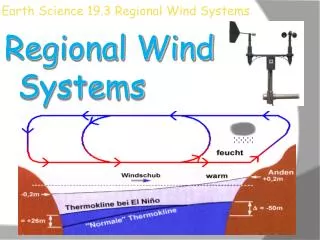
Rotating Earth Model • If the effect of rotation is added to this global circulation system we just examined, the two cell convection system would break down into smaller cells. • The figure at right shows three sets of cells that carry out this function; the Polar cell, Ferrel cell, and Hadley cell. • The polar and tropical cells function much the same way as they did in the non-rotating model. Circulation patterns in the mid-latitude Ferrel cell zone, is a more complex matter however.
Rotating Earth Model • Near the equator, rising air produces a pressure zone known as the equatorial low; a region characterized by abundant precipitation (heavy rain). • See the figure at the right: the upper level flow from the equatorial low reaches about 20 to 30 degrees latitude (about the Tropic of Cancer or Capricorn) and then sinks back toward the surface in a loop called the Hadley cell.
Rotating Earth Model • The sinking of air, and it’s associated heating due to compression, produce hot dry conditions. • The center of this zone of sinking dry air is the subtropical high around 30 degrees north and south latitude; areas known as the Tropic of Cancer and Tropic of Capricorn. • The great deserts of Australia, Arabia, and North Africa exist because of this stable dry air system associated with sub-tropical highs.
Rotating Earth Model • At the surface, airflow moves outward from the center of the subtropical high. • Some of the air travels toward the equator and is deflected by the Coriolis effect, producing the trade winds. • Trade winds = two belts of winds that blow almost constantly from easterly directions. • The trade winds are located between the subtropical highs and the equator.
Rotating Earth Model • The remainder of the air travels toward the poles and is deflected, generating the prevailing westerlies of the middle latitudes. • The westerlies make up the dominant west-to-east motion of the atmosphere that characterizes the regions on the polarward side of the subtropical highs. • As the westerlies move toward the poles, they encounter the cool polar easterlies in the region of the Polar cells (subpolar lows).
Rotating Earth Model • The polar easterlies are winds that blow from the polar high toward the subpolar low. • These winds are not constant winds like the trade winds. • In the polar region, cold polar air sinks and spreads toward the equator. • The interaction of these warm and cool air masses produces the stormy belt in the middle latitudes called the polar front.
Rotating Earth Model • This simplified global circulation is dominated by four pressure zones. • The subtropical and polar highs are areas of dry sinking air that flows outward at the surface, producing the prevailing winds. • The low-pressure zones of the equatorial and subpolar regions are associated with inward and upward airflow accompanied by clouds and precipitation.
Influence of Continents • Where land masses break up the ocean surface, large seasonal temperatures disrupt the global pattern of pressure zones in the atmosphere. • Large landmasses, particularly in the Northern hemisphere, become cold in the winter when a seasonal high-pressure system develops. • From this high-pressure system, seasonal air-flow is directed off the land.
Influence of Continents • In the summer, land masses are heated and develop low-pressure cells, which permit air to flow onto the land. • These seasonal changes in wind are known as monsoons. • During warm months, areas such as India experience a flow of warm, water-laden air from the Indian Ocean which produces the rainy summer monsoon.
Influence of Continents • Thewinter monsoon is dominated by dry continental air. • A similar situation exists to a lesser extent during summer over North America. • Rising, unstable air along the western side of the Bermuda High brings rain to the East coast. • At the same time, thunderstorms occur in the Southwest as moist air streams into the region from the Gulf of Mexico and the Gulf of California.