Download
1 / 14
140 likes | 273 Views
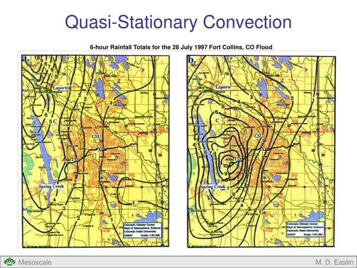
Quasi-Stationary Convection. 6-hour Rainfall Totals for the 28 July 1997 Fort Collins, CO Flood. Quasi-Stationary Convection. Basic Concept Conceptual Models Climatology of Extreme Rainfall Events Historical Events Big Thompson, CO flood – 31 July 1976 Johnstown, PA flood – 19 July 1977

E N D
Quasi-Stationary Convection 6-hour Rainfall Totals for the 28 July 1997 Fort Collins, CO Flood M. D. Eastin
Quasi-Stationary Convection • Basic Concept • Conceptual Models • Climatology of Extreme Rainfall Events • Historical Events • Big Thompson, CO flood – 31 July 1976 • Johnstown, PA flood – 19 July 1977 • Fort Collins, CO flood – 28 July 1997 • Forecasting M. D. Eastin
Basic Concept • A Offsetting Multi-Scale Process: • The motion of a given storm system is the sum of two vectors: • Cell Velocity: • Motion of individual cells that compose the system • Roughly equivalent to the deep layer mean synoptic wind • Propagation Velocity: • Motion due to the formation of new cells on the storm periphery • Related to the motion of mesoscale boundaries and their • interaction with the storm inflow (e.g., cold pool propagation) • May occur on any side: • On the leading edge → system accelerates • On a side → systems move to the “right” or “left” • On the rear flank → systems decelerates • Quasi-stationary convection occurs when the cell velocity and • propagation velocity are roughly equal and opposite Right Moving Supercell Mean Wind Mean Cell Propagation Storm Squall Line Mean Wind Propagation Mean Cell Storm Quasi-Stationary Storm Mean Wind Mean Cell Propagation Zero Storm motion M. D. Eastin
Conceptual Models • Synoptic Setting: • Maddox et al. (1979) examined the synoptic environments • for 151 quasi-stationary convective events that produce • significant flash floods • Identified two regular situations with many common • characteristics • Frontal Forcing • Nearly stationary synoptic-scale surface front • Meso-High Forcing • Nearly stationary, mesoscale, surface-outflow (cold pool) • boundary generated by previous convective activity • Characteristics Common to Both • Front/Boundary trigger convection via forced ascent • Large near-surface CIN inhibits convection except for • those regions with strong forced ascent • Upper-level winds nearly parallel to the front/boundary • Low-level flow nearly normal to the front/boundary • Mostly a summer nocturnal phenomena Frontal Forcing Meso-High Forcing M. D. Eastin
Conceptual Models • Mesoscale Organization: • Schumacher and Johnson (2005) examined radar • data for 116 MCS that produced extreme rainfall • Identified two regular organization types • Training Line – Adjoining Stratiform • 65% of cases • Convective cells develop behind a front or boundary • Cell motion parallel to the boundary, as new cells • form and move over (or train over) the same location • Stratiform precipitation forms behind the line but • also moves parallel to the boundary • Backbuilding – Quasi-Stationary • 27% of cases • Convective cells repeatedly form upstream from their • immediate predecessor (behind a boundary) • Mature and decaying cells move slowly downstream • Cell motion and propagation motion are roughly • equal and opposite (cancel each other) • Minimal stratiform precipitation located downstream From Schumacher and Johnson (2005) M. D. Eastin
Climatology of Extreme Rainfall Events • Definition and Regional Statistics: • Extreme Rainfall Event → When a surface rain gauge reports a 24-hour total rainfall • greater 125 mm (~ 5 inches) • Five year period (1999-2003) • 382 events • Most common in July • Only occur in the summer • across the northern U.S. • Year-round in southern U.S. • 74% of warm season events • were associated with MCS • (or meso-high) forcing • 95% of cold season events • were associated with strong • synoptic forcing • Tropical systems contribute • in the south and east From Schumacher and Johnson (2006) M. D. Eastin
Historical Events • Big Thompson Canyon Flood – 31 July 1976 • Quasi-stationary MCS produced 8-10 inches of rain in 1.5 hrs • Occurred 8:30 -10:00 pm LST • Killed 145 people (six bodies never recovered) and produced >$40 million in damages • Strong low-level easterly (upslope) flow of warm, moist air • Weak westerly winds aloft (above 700 mb) • Details:http://pubs.usgs.gov/fs/2006/3095/pdf/FS06-3095_508.pdf Mouth of Big Thompson Canyon 1 August 1976 Today M. D. Eastin
Historical Events • Johnstown Flood – 19 July 1977 • Associated with a slow-moving MCC that originated four days prior over South Dakota • Produced 12 inches of rain in 10 hrs across central Pennsylvania • Occurred between 7:00 pm and 5:00 am LST • Extreme precipitation caused multiple dams to overtop and break • Killed 76 people and produced >$200 million in damages • Details: Bosart, L. F., and F. Sanders, 1981: The Johnstown flood of July 1977: A long-lived • convective system, Journal of Atmospheric Science, 38, 1616-1642 Primary dam that broke Johnstown M. D. Eastin
Historical Events • Fort Collins Flood – 28 July 1997 • Quasi-stationary MCS produced >10 inches of rain in ~6 hrs • Occurred 5:00 -11:00 pm LST • Killed 5 people and produced >$200 million in damages • Details: http://olympic.atmos.colostate.edu/pdf/Petersen-Flood97.pdf From Peterson et al. (1999) M. D. Eastin
Historical Events • Fort Collins Flood – Synoptic Conditions • A 500-mb ridge axis over northeast CO • Strong low-level easterly (upslope) flow • Deep layer of moist air • Modest CAPE at ~850 J/kg • Weak southwesterly winds aloft Denver Sounding Edge of warm moist air Cold cloud tops Surface Winds 500mb Vorticity Maxima From Peterson et al. (1999) M. D. Eastin
Historical Events • Fort Collins Flood – Mesoscale Organization • A quasi-stationary back-building MCS • New cells repeatedly developed • over southern Fort Collins as • their mature and decaying • predecessors moved slowly north • across the city From Peterson et al. (1999) M. D. Eastin
Forecasting • Guidelines: • Prior to the development of convection, look for: • Strong low-level flow normal to a front, outflow boundary, or orographic feature • Warm and moist low-level air • Modest CAPE (500-1000 J/kg) • Large CIN (>200 J/kg) • Weak mid- and upper-level flow parallel to a pre-existing front or boundary • Once convection has developed, look for and monitor: • Surface wind observations roughly equal and opposite middle and upper-level winds • Cell motion parallel to fronts or outflow boundaries • Slow moving, back-building systems on radar • Radar-derived estimates of total precipitation M. D. Eastin
Quasi-Stationary Convection • Summary: • Basic Concept • Cell Velocity • Cell Propagation • Conceptual Models • Frontal Forcing • Meso-high Forcing • Training Line • Back-building • Climatology of Extreme Rainfall Events • Historical Events • Big Thompson, CO flood – 31 July 1976 • Johnstown, PA flood – 19 July 1977 • Fort Collins, CO flood – 28 July 1997 • Forecasting Guidelines M. D. Eastin
References Bosart, L. F., and F. Sanders, 1981: The Johnstown flood of July 1977: A long-lived convective system, J. Atmos. Sci., 38, 1616-1642. Chappell, C., 1986: Quasi-stationary convective events. Mesoscale Meteorology and Forecasting, P. S. Ray, Ed. Amer. Meteor. Soc., 289-310. Maddox, R. A., C. F. Chappell and L. R. Hoxit, 1979: Synoptic and mesoscale aspects of flash flood events. Bull. Amer. Meteor. Soc., 60, 115-123. Maddox, R. A., L. R. Hoxit, C. F. Chappell, and F. Caracena, 1978: Comparison of the meteorological aspects of the Big Thompson and Rapid City flash floods. Mon. Wea. Rev., 106, 375–389. Petersen, W. A., L. D. Carey, S. A. Rutledge, J. C. Knievel, R. H. Johnson, N. J. Doesken, T. B. McKee, T. Vonder Haar, and J. F. Weaver, 1999: Mesoscale and radar observations of the Fort Collins flash flood of 28 July 1997. Bull. Amer. Meteor. Soc., 80, 191–216 Schumacher, R. S. and R. H. Johnson, 2005: Organization and environmental properties of extreme-rain-producing mesoscale convective systems. Mon. Wea. Rev., 133, 961-976. M. D. Eastin