Download

1 / 21
210 likes | 424 Views
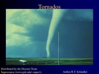
Tornados and Climate Change. Michael Pateman And Drew Vankat. What is a tornado?. An intense, rotating column of air extending from the base of a thunderstorm cloud to the ground. www.spc.noaa.gov. Ingredients for tornado formation:. Polar jet stream Low pressure trough Inversion layer

E N D
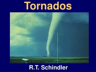
Tornados and Climate Change Michael Pateman And Drew Vankat
What is a tornado? • An intense, rotating column of air extending from the base of a thunderstorm cloud to the ground. www.spc.noaa.gov
Ingredients for tornado formation: • Polar jet stream • Low pressure trough • Inversion layer • Layer of warm humid air near surface • Triggering mechanism Ahrens, C. Donald. Meteorology Today, pp407-8
How are they formed? • Supercell Thunderstorms • Large • Long-lasting • Complex • Mesocyclones • Area of rotating air in a severe thunderstorm • May be stretched vertically, increasing rate of rotation • Can protrude downward, through base of storm • Funnel cloud • Becomes a tornado when contact is made with ground
Tornado Structure • Extremely low pressures • Estimated 10 percent less than the immediate surrounding area • Steep pressure gradient • Wind speeds of up to 300 miles an hour
Weaker tornadoes: one vortex • Larger, stronger tornadoes: several smaller 'suction vortexes’ • very concentrated • often no larger than 10 meters in diameter
Where are they found? • United States • Great Plains during spring and summer • “Tornado Alley” • All over the world
Tornado Magnitude • Fujita Tornado Damage Scale • Measures strength and intensity • Ratings from F0 (weakest) to F5(most powerful)
Fujita Scale • Category F0: Light Damage (<73 mph); Some damage to chimneys; branches broken off trees; shallow-rooted trees pushed over; sign boards damaged. • Category F1: Moderate Damage (73-112 mph); Peels surface off roofs; mobile homes pushed off foundations or overturned; moving autos blown off road. • Category F2: Considerable Damage (113-157 mph); Roofs torn off frame houses; mobile homes demolished; boxcars overturned; large trees snapped or uprooted; light-object missiles generated; cars lifted off ground. www.noaa.gov/tornadofacts.html
Category F3: Severe Damage (158- 206 mph); Roofs and some walls torn off well-constructed houses, trains overturned; most trees in forest uprooted; heavy cars lifted off ground and thrown. • Category F4: Devastating Damage (207- 260 mph); Well-constructed houses leveled; structure with weak foundations blown off some distance; cars thrown and large missiles generated. • Category F5: Incredible Damage (261- 318 mph); Strong frame houses lifted off foundations and swept away; automobile sized missiles fly through the air in excess of 100 meters; trees debarked; incredible phenomena will occur. www.noaa.gov/tornadofacts.html
ENSO • The ENSO (El Nino/ Southern Oscillation) cycle refers to the coherent, large-scale fluctuation of ocean temperatures, rainfall, atmospheric circulation, vertical motion and air pressure across the tropical Pacific. http://www.cpc.ncep.noaa.gov/
When has it happened? • La Nina • 1951 • 1952 • 1956 • 1965 • 1971 • 1974 • 1989 El Nino • 1958 • 1964 • 1966 • 1969 • 1973 • 1983 • 1987 • 1988 • 1992 • 1995
What is El Nino? • a disruption of the ocean-atmosphere system in the Tropical Pacific • development of abnormally warm sea surface temperatures across the eastern tropical Pacific • having important consequences for weather and climate around the globe. • These consequences can include increased rainfall in some areas (which can lead to flooding) • extreme drought in others.
What is La Nina? • Characterized by unusually cold ocean temperatures in the Equatorial Pacific • US warmer southwest winters, colder Northwest
How do they affect Tornados? • Mideastern US April 3 - 4, 1974 - Massive Tornado outbreak - “Classic La Nina Year” • In Ohio 16 Tornados • All within 6 hrs of each other • 5 - F1 4 - F2 2 - F3 2 - F4 3 - F5 • Coincidence?
Tornado Data (Texas) # Tornados • 1950’s 647 • 1960’s 1195 • 1970’s 1484 • 1980’s 1492 • 1990’s 1836
Tornado Data (Nebraska) # Tornados • 1950’s 319 • 1960’s 302 • 1970’s 405 • 1980’s 377 • 1990’s 701
Tornado Data (Ohio) # Tornados • 1950’s 71 • 1960’s 148 • 1970’s 202 • 1980’s 165 • 1990’s 251
Data • http://www4.ncdc.noaa.gov/cgi-win/wwcgi.dll?wwEvent~Storms • All Tornado Data downloaded from this site. • Any questions?