Download
1 / 1
10 likes | 146 Views
NaviMe : The Indoor Tour Guide System Amber Imam, Wai Yong Low, Rashmi Sanbhadti, Sudeep Yegnashankaran. Motivation. Architecture.

E N D
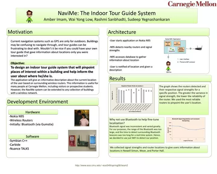
NaviMe: The Indoor Tour Guide System Amber Imam, Wai Yong Low, Rashmi Sanbhadti, Sudeep Yegnashankaran Motivation Architecture Current navigation systems such as GPS are only for outdoors. Buildings may be confusing to navigate through, and tour guides can be frustrating to deal with. Wouldn’t it be nice if you could have your own tour guide that gave information about locations only you were interested in? Objective: To design an indoor tour guide system that will pinpoint places of interest within a building and help inform the user about where he/she is. The application will give an informative description about the current location of the user based on surrounding wireless routers. This information is useful for many people at Carnegie Mellon, including visitors or prospective students. However, the NaviMe system can be extended to any collection of buildings with a wireless network. • User starts application on Nokia N95 • N95 detects nearby routers and signal strengths • N95 accesses database to gather information about location • User is notified of location and given a description Results The graph shows the routers detected and their respective signal strengths for a specific position. The greater the variance in signal strength, the lower the reliability of the router. We used the most reliable routers to pinpoint the user’s location. Development Environment • Hardware • Nokia N95 • Wireless Routers • Initially: Bluetooth (via Gumstix) Why not use Bluetooth to help fine-tune localization? Bluetooth signal was inconsistent and varied greatly. For our purposes, the range of the Bluetooth was too large, and the time to detect surrounding Bluetooth beacons was too long for a real-time system. Hence, we decided to use just WiFi to detect our position. • Software • Symbian C++ • Carbide • Nuance TALKS We collected signal strengths and router locations to give users information about locations in Newell Simon, Wean, and Porter Hall. http://www.ece.cmu.edu/~ece549/spring08/team2