Download
1 / 178
1.95k likes | 2.64k Views
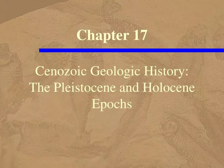
Chapter 17 . Cenozoic Geologic History: The Pleistocene and Holocene Epochs. Jungfrau Firn, Switzerland. The Jungfrau Firn mergers with two other valley glaciers to form the Aletsch Glacier Valley glaciers are present on all continents except Australia,

E N D
Chapter 17 Cenozoic Geologic History: The Pleistocene and Holocene Epochs
Jungfrau Firn, Switzerland • The Jungfrau Firn mergers with two other valley glaciers • to form the Aletsch Glacier • Valley glaciers are present on all continents • except Australia, • but during the Pleistocene Epoch (the Ice Age) • they were more numerous and much larger than they are now
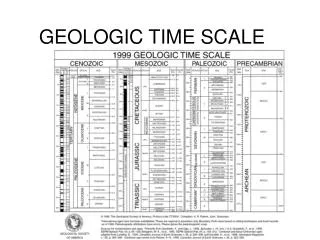
The Pleistocene Epoch • The Pleistocene Epoch and • Holocene or Recent Epoch • are the designations for the most recent • 1.8 million years of geologic time • In the past, the Quaternary Period • encompassed the Pleistocene and Holocene • but more recently the Quaternary • is a subperiod within the Neogene
The Pleistocene Epoch • The chronostratigraphic status • of the Quaternary • has not been resolved, • and we will not reference it • Accordingly, the Pleistocene and Holoceone epochs • are the last two epochs • of the Neogene Period
Cenozoic Time Scale • The geologic time scale • for the Cenozoic Era • The Pleistocene Epoch • from 1.8 million to 10,000 years ago • takes up more time than the Holocene
Pleistocene: 38 Seconds • Recall our analogy of all geologic time • represented by a 24-hour clock • In this context, the Pleistocene is only 38 seconds long, • but they are certainly important seconds, • because during this time our species evolved • Homo sapiens • and it was one of the few times in Earth history • when vast glaciers were present
Geologic Time in 24-hours • The Pleistocene • is only 38 seconds long • at this scale
Pleistocene Glaciation • A glacier • is a body of ice on land • that moves as a result of plastic flow • internal deformation in response to pressure • and by basal slip • sliding over its underlying surface • Continental glaciers cover at least 50,000 km2 and are unconfined by topography • Ice caps are similar, • but cover less than 50,000 km2 • while valley glaciers are long tongues of ice • confined to mountain valleys
Continental Glacier • The West and East Antarctic Ice sheets merge to form a nearly continuous ice cover • that averages 2160 m thick.
Ice Cap • The Penny Ice Cap on Baffin Island, Canada, • covers about 6000 km2
Valley Glacier • A valley glacier such as this one in Alaska • is a long, narrow tongue of moving ice • confined to a mountain valley
Biblical Deluge Versus Glaciers • In hindsight, it is difficult to believe • that many scientists of the 1830s • refused to accept the evidence • indicating that widespread glaciers • were present on the Northern hemisphere continents during the recent geologic past • Many invoked the biblical deluge • to explain the large boulders throughout Europe • far from their source; • whereas others thought the boulders • were rafted by ice during vast floods
Louis Agassiz • By 1837, • Swiss naturalist Louis Agassiz • argued convincingly • that the large displaced boulders • as well as polished and striated bedrock and U-shaped valleys • in many areas • resulted from huge masses of ice • moving over the land
Glacial Features • Features seen in areas once covered by glaciers • glacial polish • the sheen • striations • scratches • These features are convincing evidence that • a glacier moved over these rocks • in Devil’s Postpile National Monument, California
Fluctuating Climate • We now know that the Pleistocene Epoch, • more popularly known as the Ice Age, • was a time of several major episodes of • glacial advances • separated by warmer interglacial intervals • In addition, during times of glacial expansion • more precipitation fell in regions now arid, • such as the Sahara Desert of North Africa • and Death Valley in California • both of which supported streams, lakes, and lush vegetation
Unresolved Questions • Indeed, cultures existed • in what is now the Sahara Desert • as recently as 4500 years ago • Is the Ice Age is truly over? • Or are we in an interglacial period • that will be followed by renewed glaciation?
Pleistocene Glaciation • We focus on Pleistocene glaciers • because they had such a profound impact • on the continents • but remember that even at their maximum extent • glaciers covered only about 30% of Earth’s land surface. • Of course, the climatic conditions that led to glaciation • had world-wide effects, • but other processes were operating as usual • in the nonglaciated areas
Systems Approach • From the systems approach, • glaciers are part of the hydrosphere, • although some geologists • prefer the term cryosphere • for all of Earth’s frozen water, • which includes glaciers, sea ice, snow, • and even permafrost • permanently frozen ground
Pleistocene and Holocene Tectonism and Volcanism • The Pleistocene is best known for vast glaciers and their effects, • but it was also a time • of tectonism and volcanism, • processes that continued through the Holocene to the present • Today plates diverge and converge, • and, in places, slide past one another • at transform plate boundaries • As a consequence, orgoenic activity is ongoing • as is seismic activity and volcanic eruptions
Tectonism • These areas of orogenic activity continue unabated • the continent-continent collision • between India and Asia • and the convergence of the Pacific plate • with South America that formed the Andes • As do those • in the Aleutian Islands, • the Philippines, • and elsewhere
Uplift and Deformation • Interactions between • the North American and Pacific plates • along the San Andreas transform plate boundary • produced folding, faulting, • and a number of basins and uplifts • Marine terraces • covered with Pleistocene sediments • attest to periodic uplift along the US Pacific Coast
Marine Terraces • Marine terraces on the west side of San Clemente Island, California • Each terrace represents a period when that area was at sea level • The highest terrace is now about 400 m above sea level
Deformed Sedimentary Rocks • These deformed sedimentary rocks are only a few hundred meters • from the San Andreas Fault in southern California
Volcanism • Ongoing subduction of remnants • of the Farallon plate • beneath Central America and the Pacific Northwest • accounts for volcanism in these two areas • The Cascade Range • of California, Oregon, Washington, and British Columbia • has a history dating back to the Oligocene, • but the large volcanoes and Lassen Peak, • a large lava dome, • formed mostly during the Pleistocene and Holocene • Lassen Peak (California) and Mount St. Helens (Washington) • erupted during the 1900s, • and Mount St. Helens showed renewed activity in 2004
Mount Bachelor • Mount Bachelor at 11,000 to 15,000 years old is the youngest volcano in the range
Other Volcanism • Volcanism also occurred in several other areas • in the western United States including • Arizona, Idaho, and California • Following colossal eruptions, huge calderas formed • in the area of Yellowstone National Park, WY • Vast eruptions took place 2.0 and 1.3 million years ago • and again 600,000 years ago • that left a composite caldera • Since its huge eruption, part of the area has risen, • presumably from magma below the surface, • forming a resurgent dome • And finally, between 150,000 and 75,000 years ago, • the Yellowstone Tuff was erupted • and partially filled the caldera
High Hole Crater • This 115-m-high cinder cone lies on the flank of a huge shield volcano in northern California • The aa lava flow in the foreground was erupted 1100 years ago
McCloud River Lower Falls • The Lower Falls of the McCloud River in California • plunges 3.5 m over a precipice • in a Pleistocene lava flow
Other Volcanism • Elsewhere, volcanoes erupted in • South American, the Philippines • Japan, the East Indies, • as well as in Iceland, Spitzbergen, and the Azores • Even though the amount of heat • generated within Earth • has decreased through time, • volcanism and other processes • driven by internal heat • remain significant processes
Pleistocene Stratigraphy • Although geologists continue to debate • which rocks should serve as the Pleistocene stratotype • Recall that a stratotype is a section of rocks where a named stratigraphic unit such as a system or series was defined • they agree that the Pleistocene Epoch began 1.8 million years ago
Pleistocene–Holocene Boundary • The Pleistocene-Holocene boundary • at 10,000 years ago, • is based on climatic change • from cold to warmer conditions • concurrent with the melting • of the most recent ice sheets • Changes in vegetation • as well as oxygen isotope ratios • determined from shells of marine organisms • provide ample evidence for this climatic change
Terrestrial Stratigraphy • Soon after Louis Agassiz proposed his theory for glaciation, • research focused on deciphering the history of the Ice Age • This work involved recognizing and mapping • terrestrial glacial features • and placing them in a stratigraphic sequence
Glaciers Three km Thick • From glacial features such as • moraines, • erratic boulders, • and glacial striations, • geologists have determined that • Pleistocene glaciers at their greatest extent • up to 3 km thick • covered about three times • as much of Earth's surface • as they do now • or about 45,000,000,000 km2
Glaciers in North America • Centers of ice accumulation • and maximum extent • of Pleistocene glaciers • in North America
Glaciers in Europe • Centers of ice accumulation • and maximum extent • of Pleistocene glaciers • in Europe
Mapping • Detailed mapping of glacial features • reveals that several glacial advances and retreats occurred • By mapping the distribution glacial deposits, • geologists have determined • that North America • has had at least four major episodes • of Pleistocene glaciation
Four Glacial Stages • Each glacial advance • was followed by retreating glaciers • and warmer climates • The four glacial stages, • the Wisconsinan, • Illinoian, • Kansan, • and Nebraskan, • are named for the states • where the southernmost glacial deposits • are well exposed
Three Interglacial Stages • The three interglacial stages, • the Sangamon, Yarmouth, and Aftonian, • are named for localities • of well exposed interglacial soil and other deposits • Recent detailed studies of glacial deposits • indicate, however, that there were • an as yet undetermined number • of pre-Illinoian glacial events • and that the history of glacial advances and retreats • in North America • is more complex than previously thought
Traditional Pleistocene Terminology • Traditional terminology for Pleistocene glacial and interglacial stages in North America
Succession of Deposits • Idealized succession of deposits and soils • developed during the glacial and interglacial stages
Advances in Europe • Six or seven major glacial advances and retreats • are recognized in Europe, • and at least 20 major warm–cold cycles • have been detected in deep-sea cores • Why isn't there better correlation • among the different areas • if glaciation was such a widespread event? • Part of the problem is that • glacial deposits are typically chaotic mixtures • of coarse materials that are difficult to correlate
Minor Fluctuations • Furthermore, glacial advances and retreats • usually destroy the sediment left by the previous advances, • obscuring older evidence • Even within a single major glacial advance, • several minor advances and retreats may have occurred • For example, careful study of deposits • from the Wisconsinan glacial stage • reveals at least four distinct fluctuations • of the ice margin during the last 70,000 years • in Wisconsin and Illinois
Deep-Sea Stratigraphy • Until the 1960s, the traditional view • of Pleistocene chronology • was based on sequences of glacial sediments on land • However, new evidence • from ocean sediment samples • indicate numerous climatic fluctuations • during the Pleistocene
Evidence for Climatic Fluctuations • Evidence for these climatic fluctuations • comes from changes in surface ocean temperature • recorded in the shells of planktonic foraminifera, • which after they die sink to the seafloor • and accumulate as sediment • One way to determine past changes • in ocean surface temperatures • is to resolve whether planktonic foraminifera • were warm- or cold-water species
Response to Temperature • Many planktonic foraminifera are sensitive to variations in temperature • and migrate to different latitudes • when the surface water temperature changes • For example, the tropical species • Globorotalia menardii • during period of cooler climate • is found only near the equator, • whereas during times of warming • its range extends into the higher latitudes
Coiling Direction • Some planktonic foraminifera species • change the direction they coil during growth • in response to temperature fluctuations • The Pleistocene species • Globorotalia truncatulinoides coils predominantly • to the right in water temperatures above 10°C • but coils mostly to the left in water below 8°-10°C • On the basis of changing coiling ratios, • geologists have constructed detailed climatic curves • for the Pleistocene and earlier epochs
Oxygen Isotope Ratio • Changes in the O18-to-O16 ratio • in the shells of planktonic foraminifera • also provide data about climate • The abundance of these two oxygen isotopes • in the calcareous (CaCO3) shells • of foraminifera • is a function of the oxygen isotope ratio in water molecules • and water temperature when the shell forms • The ratio of these isotopes • reflects the amount of ocean water stored • in glacial ice
Lighter Isotopes in Glacial Ice • Seawater has a higher O18-to-O16 ratio • than glacial ice • because water containing the lighter O16 isotope • is more easily evaporated • than water containing the O18 isotope • Therefore, Pleistocene glacial ice • was enriched in O16 relative to O18, • while the heavier O18 isotope • was concentrated in seawater
Climate Change from Isotopes • The declining percentage of O16 • and consequent rise of O18 in seawater • during times of glaciation • is preserved in the shells of planktonic foraminifera • Consequently, oxygen isotope fluctuations • indicate surface water temperature changes • and thus climatic changes
Ocean Surface Temperature • O18-to-O16 isotope ratios • from a sediment core in the western Pacific Ocean • indicate that ocean surface temperatures • changed during the last 56 million years • A change from warm to colder conditions • took place 32 million years ago