Download
1 / 42
420 likes | 608 Views
The Extreme Heat Climatology of WFO St. Louis (LSX) CWA. Mark F. Britt National Weather Service St. Louis, MO. Why Study Heat?. Extreme Heat is the biggest killer in MO & IL 1995-2006 (StormData and State of Missouri).

E N D
The Extreme Heat Climatology of WFO St. Louis (LSX) CWA Mark F. BrittNational Weather ServiceSt. Louis, MO
Why Study Heat? Extreme Heat is the biggest killer in MO & IL 1995-2006(StormData and State of Missouri). *583 of these deaths occurred in the Chicago Metro area in July 12-16, 1995.**852 deaths in Missouri from 1980-2005
Why Am I Here? Gain a basic understanding of heat index climatology that can: • Answer media queries • Provide background information when forecasting extreme heat days.
Why Am I Here? • Examine the Heat Index (HI) equation. • Examine how often advisories and warnings are required. • Examine HI distributions: • Annually • Monthly • Hourly • Temperature • Minimum Temperature • Dewpoint • Temperature vs. Dewpoint • Wind Direction • Wind Speed • Examine composites of the advisory and warning HI days.
Database • Thirty four years (1973-2006) of hourly temperature and dewpoint data collected by the National Climatic Data Center (NCDC) and the Midwest Climate Center (MCC). • Did examine hourly data from 1930-1973 on days with a maximum temperature >102o F.However, this database did not yield any additional significant information.
Methodology • . Some defintions: • A heat advisory hour (HAH) is when the HI at one of these sites is between 105oF and 114oF. Because of the 5oF assumption for the city of St. Louis, a HAH is between 100oF and 109oF using the STL observation. • A heat warning hour (HWH) is when the HI at one of these sites is 115oF (110oF for the city). • A heat advisory day is a calendar day (CDT) with at least 3 HAH (not necessarily consecutive). • An intensity warning day is the same as an advisory day, only using HWH. • A duration warning day occurs in a stretch when there are at least 3 consecutive heat advisory or warning days.
Methodology • This is a climatology study. It only looks at actual observations from STL, COU, and UIN. This study does not look at what headlines were actually issued. • Most of the distributions in this study include all HAH or HWH, regardless if they occurred on advisory or warning days (i.e. included HI hours on days with only 1 or 2 HAH or HWH). • Any reference to advisory or warning days means that there were at least 3 HAH or HWH on that day.
HeatIndex Equation • “No true equation for HI exists.” (Rothfusz, 1990) • The “equation” we use today is actually the result of a multiple regression analysis (“a round-about way”) performed on a table developed by Steadman (1979). • Steadman performed extensive biometeorological studies using parameters which can be individually modeled. • Using assumptions for most of these parameters, the “equation” is reduced to a relationship between the dry bulb temperature and humidity.
Steadman’s Parameters Vapor pressure. Ambient vapor pressure of the atmosphere.(1.6 kPa) Dimensions of a human. Determines the skin's surface area. (5' 7" tall, 147 pounds) Effective radiation area of skin. A ratio that depends upon skin surface area. (0.80) Significant diameter of a human. Based on the body's volume and density. (15.3 cm) Clothing cover. Long trousers and short-sleeved shirt is assumed.(84% coverage) Core temperature. Internal body temperature.(98.6°F) Core vapor pressure. Depends upon body's core temperature and salinity.(5.65 kPa) Surface temperatures and vapor pressures of skin and clothing. Affects heat transfer from the skin's surface either by radiation or convection. These values are determined by an iterative process.
Steadman’s Assumptions Activity. Determines metabolic output.(180 W m-2 of skin area for the model person walking outdoors at a speed of 3.1 mph) Effective wind speed. Vector sum of the body's movement and an average wind speed. Angle between vectors influences convection from skin surface (below).(5 KNOTS!!!) Clothing resistance to heat transfer. The magnitude of this value is based on the assumption that the clothing is 20% fiber and 80% air. Clothing resistance to moisture transfer. Since clothing is mostly air, pure vapor diffusion is used here. Radiation from the surface of the skin. Actually, a radiative heat-transfer coefficient determined from previous studies. Convection from the surface of the skin. A convection coefficient also determined from previous studies. Influenced by kinematic viscosity of air and angle of wind. Sweating rate. Assumes that sweat is uniform and not dripping from the body.
Heat Index Equation This equation was obtained by multiple regression analysis and there is a ±1.3 degree °F error: HI = -42.379+2.04901523T+10.14333127R - 0.22475541TR - 0.00683783T2- .05481717R2+ .00122874T2R+0.00085282TR2- 0.00000199T2R2 Where: T= ambient dry bulb temperature (°F) R= relative humidity (integer %).
(# of hour/day and max HI on that day) 2006 Year In Review
Heat Index Headlines *Days with only 1 or 2 hours meeting advisory criteria.
Heat Index Headlines Days Per Year
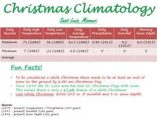
Max 81 84 78 83 83 84 83 83 Min 67 65 66 70 75 74 67 78
110 111 105 106 105 105 Max 106 106 95 95 Min 84 93 88 88 88 88
81 80 82 Max 83 83 80 82 83 54 Min 66 47 72 65 65 62 71
12 11 18 21 Max 20 20 16 20 0 Min 0 5 0 0 0 0 0
Composites Daily mean composites of several variables (500mb height, 850mb height and temperature, 925mb specific humidity, MSLP, 1000mb temperature, and precipitation rate) were generated using the North American Regional Reanalysis Dataset from the NOAA/ESRL Physical Sciences Division, Boulder Colorado. (http://www.cdc.noaa.gov). • Advisory composites were randomly selected from days that KSTL had 1.) a heat index at 21Z of 100 to 104oF and 2.) were not part of a duration warning (i.e. lower end advisories). • Warning composites were randomly selected from days that reached intensity warning criteria. • None of the dates are within 10 days of each other to prevent sampling the same pattern.
Composites 500 mb Heights Warning Advisory
Composites Precipitation Rate Warning Advisory
Composites 850 mb Heights Warning Advisory
Composites 850 mb Temperatures Advisory Warning
Composites 925 mb Specific Humidity Advisory Warning
Composites MSLP Advisory Warning
Composites 1000mb Temperature Warning Advisory
Summary • Using the current criteria, a heat advisory is needed for the city 3 to 5 times more often than the rest of the CWA. • Adding duration to the warning criteria significantly increases (5 to 20 times) the number of warnings needed. • Our “Heat Season” occurs from late June until late August, with the most intense part during mid-late July. • The peak HI for the day usually occurs between3-4 pm CDT, with “significant heat” lasting from Noon - 7 pm CDT.
Summary • Mean temperatures for an advisory are in the mid 90s, and average dewpoints are in the lower-mid 70s. • Mean temperatures during a intensity based warning are in the upper 90s, with dewpoints in the mid-upper 70s. • Average minimum temperatures during warnings and advisories are in the mid-upper 70s. • Average wind direction during warnings and advisories are south to west, and average wind speeds differences are not significantly different between warnings and advisories.
Summary • A Comparison of 20 advisory days to 20 intensity warning days at KSTL indicate: • A large 500 mb high dominating the southern 2/3rds of the nation. Heights are higher during the warning days than the advisory days. • There is less precipitation during a warning day than a advisory day over the Midwest. • High pressure is located over the southeast U.S. (Bermuda High) with trough to the west from 850mb on down. This sets up southwesterly low level flow into IL/MO. • 850mb and 1000mb temps are 3-4oC warmer on warning days than on advisory days.
Future Work • Examine an hourly dataset from COU that goes back to 1946. • Compare this database with the Heat Health System. • Update current data every yearly.
References Mesinger, Fedor, DiMego, Geoff, Kalnay, Eugenia, Mitchell, Kenneth, Shafran, Perry C., Ebisuzaki, Wesley, Jovi , Dušan, Woollen, Jack, Rogers, Eric, Berbery, Ernesto H., Ek, Michael B., Fan, Yun, Grumbine, Robert, Higgins, Wayne, Li, Hong, Lin, Ying, Manikin, Geoff, Parrish, David, Shi, Wei, 2006: North American Regional Reanalysis Bulletin of the American Meteorological Society, 87, 343-360 Rothfusz, L. P.,1990:The heat index equation (or, more than you ever wanted to know about heat index). NWS Southern Region Technical Attachment, SR/SSD 90-23, Fort Worth, TX. Steadman, R.G., 1979: The assessment of sultriness. Part I: A temperature-humidity index based on human physiology and clothing science. J. Appl. Meteor., 18, 861-873. U.S. Local Storm Events Database (1995-2004). www.ncdc.noaa.gov