Download
1 / 81
830 likes | 1.14k Views
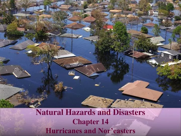
Natural Hazards and Disasters Chapter 14 Hurricanes and Nor’easters. Costliest Natural Disaster in U.S. History. With approach of Hurricane Katrina, most evacuated but many were not able

E N D
Natural Hazards and Disasters Chapter 14 Hurricanes and Nor’easters
Costliest Natural Disaster in U.S. History With approach of Hurricane Katrina, most evacuated but many were not able National Weather Service predicted that hurricane would cause catastrophic damage and ‘human suffering incredible by modern standards’ Hit New Orleans directly, drowning city Set new standard for level of damage, potential effects of flood surge, coastal development patterns, need for better disaster preparedness
Hurricanes, Typhoons and Cyclones Hurricanes: north Atlantic and eastern Pacific Typhoons: western Pacific, Japan, southeast Asia Cyclones: Indian Ocean Often called Willy Willy’s in Australia Tropical cyclone develops as large, warm-core, low-pressure system over tropical or subtropical waters with temperature of at least 25oC (77oF)
Formation of Hurricanes and Cyclones Rising air and condensation can build up into convective ‘chimney’ of thunderstorms Convection may strengthen when air rises to high elevations without strong winds to shear off and dissipate storms Begin to develop over warm seawater, between 5 and 20 degrees latitude Vertical wind shear must be minimal Becomes hurricane force when winds exceed sustained velocity of 119 km/hr Highest wind speeds exist along edge of eye wall
Formation of Hurricanes and Cyclones Warm, moist air rises and spreads at top of chimney Warm air expands, cools and releases latent heat Eye of hurricane is as much as 20°C warmer than surrounding air Rising air pulls more air into center of hurricane at low elevations Storm may be from 160 km to more than 800 km in diameter Forward motion averages 25 km/hr Winds drop abruptly in eye, pressure drops
What Hurricanes Need Warm water Converging winds Top-level outward flow Humid rising air Light winds
Hurricane-Strength Winds • Saffir-Simpson Hurricane Scale • Based on barometric pressure and average wind speed • Lower barometric pressure, stronger hurricane • Lower-category storms can do almost as much damage as higher-category storms • Storm surge • Flooding • Rain • High winds • Tornadoes
Areas at Risk • Northern hemisphere tropical cyclones: • Rotate counterclockwise, track clockwise • Southern hemisphere tropical cyclones: • Rotate clockwise, track counterclockwise
Areas at Risk • Every year: • 80-90 tropical storms • 45 hurricanes • 6 named hurricanes in Atlantic Ocean and Gulf of Mexico • Hurricanes generally curve northward as they approach U.S., due to Coriolis effect • Strengthen while over warm water of Gulf Stream • Lose energy and dissipate when they move over cooler water or land
Storm Damages • Six of top ten costliest hurricanes occurred in 2004 and 2005 • Costs related to hurricanes have dramatically increased • Rapidly growing populations along coast • More development in unsuitable locations • More expensive buildings • Number of deaths has decreased • Improved ability to predict landfall locations • Coordinated ability to evacuate populations at risk
Storm Surges • Low atmospheric pressure helps cause sea level under storm to rise • Prolonged high winds push seawater into mounds as high as 7.3 m and 80-160 km wide • Storm surges pile up and rise even higher when approaching shallower coastline, or funneled into bay, inlet, harbor, or river channel • 90% of tropical cyclone deaths result from storm-surge flooding • Highest surge levels in north to northeast quadrant of storm • Forward movement of storm enhances wind speed • Hurricane arriving perpendicular to coastline has higher storm surge
Northeast Quadrant Northeast Quadrant September, 2005 – Category 5 on the Saffir-Simpson Scale
Storm Surges Faster storm movement pushes storm surge into higher mound Slower storm movement brings lower storm surge, but stays in place longer, builds higher waves Storm-surge waters slowed by vegetation, dunes Low area or gap in vegetation allows water to flow faster and erode gap deeply, sometimes washing area away Buildings and structures can be washed away by storm surge, or can float away if undermined or not well anchored Surge arriving at high tide rises even higher
By the Numbers Atmospheric Pressure Affects Surge Height h = 43.3 – 0.0433 Po where h = height of surge (m) Po = pressure in eye of hurricane (hPa or millibars)
By the Numbers Surge Height Depends on Wind Speed, Fetch and Water Depth (height)2awind speed x (fetch length – water depth)
Waves and Wave Damages Higher waves impact coast with much more energy Wide, gently sloping continental shelf slows waves, uses up wave energy, decreases damage Narrow continental shelf or steeper slope causes larger waves and increases damage Fringing coral reefs force waves to break well offshore, decreasing damage Low-lying islands more vulnerable to wind damage and storm surge
Winds and Wind Damages Wind velocity has major effect on wave height Damage is greatly magnified by flying debris Wind does greatest damage to buildings Largest wind forces are suction, pulling up
Rainfall and Flooding Significant flooding from large amounts of rain Rain can wash out structures, drown people, contaminate water supplies, trigger landslides
Deaths • Depend not only on strength of hurricane through wind velocity and surge height • Also depend on: • Buildings too close to coast • Buildings too close to sea level • Buildings that are too weakly constructed • People’s lack of awareness of wide range of hazards • Large population in path of storm that can not evacuate quickly enough
Deaths Much higher rates of death in poor countries Mountainous areas are deforested, more vulnerable to landslides Low-lying coastal areas are easily flooded Deadliest Atlantic hurricanes have affected Caribbean islands
Social and Economic Impacts • Disruptions from Hurricane Katrina shut down 95% of Gulf of Mexico petroleum output • Gasoline prices rose dramatically • Families may be separated in evacuation, then unable to contact one another • Many people lack flood insurance • Widespread job losses • Companies can not reopen • Government will not rebuild infrastructure until people return • People will not return without adequate infrastructure • People get very protective of their property • Crime increases
Social and Economic Impacts • Many New Orleans residents want to rebuild homes in flood zones • By late 2007, city population was 63% of its original 450,000 • Significant portion in 20% of city that was not flooded • Lower 9th Ward: only 1,055 of more than 13,000 people returned • In 2006, city council ruled that rebuilt houses had to be raised one meter • Many areas were flooded with 5-6 m of water • $6 billion upgrade of levees will not be finished until 2010, won’t provide much more protection than old levees
Climate Change and Hurricane Damage • Hurricane damage is amplified by: • Heavy or prolonged rain • Surge height and shape of coast • High winds and storm waves • Warm-water eddies to add energy • Storms stalled by other weather systems • One-two punch could be two or more large, back-to-back hurricanes • See: Case-in-Point, Hurricanes Dennis and Floyd, 1999 • Category 3 Hurricane Dennis stayed offshore North Carolina for days, eroding beaches with big waves equivalent to Category 4 • Ten days later, Hurricane Floyd hit coasts as strong Category 2 storm
Climate Change and Hurricane Damage On average, five hurricanes develop in Atlantic Ocean every year, two of them major Increases in sea-surface temperatures suggests more hurricanes in next few decades
Climate Change and Hurricane Damage • Model-based climate change detection/attribution studies have linked increasing tropical Atlantic SSTs to increasing greenhouse gases, but the link between increasing greenhouse gases and hurricane PDI (Power Dissipation Index) or frequency has been based on statistical correlations • The statistical linkage of Atlantic hurricane PDI to and Atlantic SST in Figure 1 suggests at least the possibility of a large anthropogenic influence on Atlantic hurricanes • If the correlation between tropical Atlantic SSTs and hurricane activity shown in Figure 1 is used to infer future changes in Atlantic hurricane activity, the implications are sobering • The large increases in tropical Atlantic SSTs projected for the late 21st century would imply very substantial increases in hurricane destructive potential--roughly a 300% increase in the PDI by 2100 (Figure 2 a)
Hurricane Prediction and Planning National Hurricane Warning Center tries to give 12 hours warning of hurricane path Time of arrival is moderately predictable Specific location of landfall and storm strength at landfall are poorly known more than day or two in advance Storms are monitored by weather satellites and ‘hurricane hunter’ aircraft that fly into storms to collect data on winds and atmospheric pressures
Hurricane Prediction and Planning • Hurricane watch: • ‘A hurricane is possible in the watch area within 36 hours’ • Hurricane warning: • ‘A hurricane is expected in the warning area within 24 hours’ • More accurate forecasting could save lives and significant evacuation costs
Uncertainty in Hurricane Prediction Hurricanes can quickly change path or increase in intensity National Hurricane Center’s current 24-hour lateral forecast error for path of hurricane is 80 km Smaller storms can quickly gain energy to become powerful hurricanes Hurricane’s energy is drawn from heat in tropical water Presence of large eddies of warm water can boost energy of hurricanes passing over them
Planning for Hurricanes Should prepare house for potential hazards, in anticipation of having little or no warning Bring in or securely anchor anything that could become a projectile in high winds Board up windows, garage doors, shutters Store clean drinking water Move boats to safe place above storm-surge height Stock up on prescription medications, food and water Fill vehicle’s gas tank Turn refrigerator to coldest setting Turn off other appliances Turn off main natural gas line or propane tanks Evacuate when authorities say to do so
Evacuation Many more people are warned to evacuate than those in final path of storm Costs of evacuations are very large Most people living in areas subject to hurricanes have never been involved in an evacuation People have various reasons for choosing not to evacuate Most evacuations take up to 30 hours Huge increase in coastal population has outgrown capacity of highways Most difficult area of U.S. to evacuate is Florida peninsula
Managing Future Damages • Governments, communities and insurances companies beginning to react to damages and costs from hurricanes • ‘Disaster-resistant communities’ • Less vulnerable, reduced costs from coastal hazards • Land use planning, building codes, incentives, taxation, insurance • Tourism is largest source of income for most coastal areas • Governing bodies are reluctant to publicize vulnerability or restrict tourist income
Natural Protections Beachfront sand dunes absorb wave energy and surge, reduce damage Vegetation can dramatically slow landward advance of surge and waves Alterations of dunes and mangrove stands that would increase potential flood damage are prohibited Walking on dunes is prohibited Damage to New Orleans in Hurricane Katrina was probably increased by dredging and oil drilling sites, which killed off cypress forests and marshes Mississippi River delta and adjacent wetlands have been shrinking
Building Codes People should have second thoughts about rebuilding in same location after obliteration by major hurricane, but they tend not to Developers snap up coastal building sites Homes can be made much more resistant to hurricane damage at cost of 1.8-3.7% increase Increased standards are often resisted State and local governments responsible for creating and enforcing their own codes
Flood Insurance • One way to reduce monetary damages from hurricanes and to keep people from building in inappropriate areas • Some states dictate setback line based on probability of coastal flooding • Insurance companies will not cover homes built seaward of line against wave damage • National Flood Insurance Program requires mapping of areas subject to river and coastal floods • Purpose of mapping is to implement Flood Insurance Rate Map provided by FEMA
Flood Insurance • National flood insurance premiums are higher for more vulnerable areas • Coastal building standards for NFIP require: • New construction must be landward of mean high tide • New construction and major improvements must be elevated on piles, so lowest floor is above base flood elevation for 1% chance of being flooded in given year • Areas below lowest floor must be open or have breakaway walls