Download
1 / 63
650 likes | 1.04k Views
Introduction to Oracle Spatial Using Public Data. Richard L. Flores Isinglass, Inc. pleides100@yahoo.com. About Me. Schooling in Geology and Business. 15 years working with Geographical Information Systems and Computer Mapping in the Oil & Gas Industry.

E N D
Introduction to Oracle Spatial Using Public Data Richard L. Flores Isinglass, Inc. pleides100@yahoo.com
About Me • Schooling in Geology and Business. • 15 years working with Geographical Information Systems and Computer Mapping in the Oil & Gas Industry. • 16 years working with Oracle, mostly as DBA.
Reading Material • Clearly written with wonderful, downloadable examples for you to work through. • Covers most features of Oracle Spatial.
Reading Material • Wide ranging topics on the FREE acquisition of data and tools for the processing of geographic data. • Great tips and insight on the field of Electronic Cartography.
Agenda • Geographic Data Processing • Cartography 101 • Oracle Spatial Products • Oracle Spatial Basics by Example
Geographic Data ProcessingThe Processing Steps • Data Acquisition • Preliminary Data Processing • Data Storage and Retrieval • Graphical Display (Visualization), Analysis, and Interaction.
Geogaphic Data ProcessingData Acquisition • Sources • Global Positioning Systems (GPS) • Published and Unpublished • Free and Commercial • Formats • Vector: shapefiles, DLG, DXF, NTF, etc. • Raster: TIFF, GIF, etc.
Geogaphic Data ProcessingPreliminary Data Processing • May Involve • Digitization of paper maps • Vectorization of raster images • Transformation of Mapping Coordinates • Geocoding: calculation of geographic coordinates from street addresses.
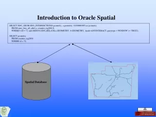
Geogaphic Data ProcessingData Storage and Retrieval • For Oracle • Storage • Use of Oracle’s Geographic Data Model • Database design for the integration of spatial and non-spatial data • SQL and SQL*Loader for loading data in Oracle. • Oracle’s “shapefile” to “SDO” utility. • Retrieval • It all comes down to SQL using Oracle Spatial stored procedures.
Geogaphic Data ProcessingDisplay, Analysis, and Interaction. • Not many free programs that work with Oracle Spatial directly, unfortunately. • Many commercial programs for displaying and interactively querying and editing Oracle Spatial data such as those from ESRI, Intergraph, MapInfo, Autodesk, eSpatial, and Acquis.
Cartography 101The Shape of the Earth: Some Facts • To accurately place a point on the earth, the general shape of the earth must be known. These shape models are called, datums. • The earth is not flat.1 • The earth is not a perfect sphere. • The earth’s general shape is best described by a theoretical surface called a geoid. • For mapping, geoids are approximated by reference ellipsoids. 1 Assertions of the Flat Earth Society notwithstanding.
Cartography 101 The Shape of the Earth: North American Datum • Older maps used NAD27 • Newer maps use the more accurate NAD83 made using satellites and sophisticated electronic equipment. • Worldwide GPS use a datum compatible to NAD83 called WGS84 • The coordinates for a point on the earth can vary significantly depending on the datum used.
Cartography 101 Spatial Reference Systems • SRS are coordinate-based systems used to locate geographical entities. • Oracle Geographic SRS Types • Geodetic: Latitude & Longitude • Projected Coordinate Systems: X & Y where globe is mathematically “projected” onto a flat map.
Cartography 101Why are SRS important? • During analysis, if all spatial data is not in the same Spatial Reference System, the geographic layers will not overlay and the analysis will be in error.
Cartography 101Why are SRS important? • During analysis, if an inappropriate Spatial Reference System is chosen, you may introduce unacceptable distortion into your maps.
Cartography 101Why are SRS important? • If you were interested in using a map to measure land areas, you would probably not use this Spatial Reference System.
Cartography 101Geodetic Coordinate System • Latitude/Longitude expressed in Degrees/Minutes/Seconds or Decimal Degrees • Parallels: Lines of latitude North (+) & South (-) of Equator (-90 to +90) • Meridians: Lines of longitude East (+) & West (-) of the Prime Meridian (-180 to +180) • Oracle Uses Decimal Degrees in the odd order, Longitude/Latitude
Cartography 101 State Plane Coordinate Systems • Each state has defined SPCS zones which are popular for local- and state-sized areas because of their accuracy. • In General: • “Tall” States, such as NM use the Universal Transverse Mercator Projection. • “Wide” States, such as TX use Lambert Confromal Conic Projection. California Zone III, 0403 Texas South Central Zone, 4204
Cartography 101Projected Coordinate Systems • Select map projection for display based on: • How you intend to use the data • The size, location, and orientation of the area of interest • The metric property of the map you wish to preserve: • Shape • Area • Distance • Direction • Scale • See erg.usgs.gov/isb/pubs/MapProjections/projections.html
Oracle ProductsOracle Locator • Includes • Geographic Data Model • Query and Analysis using the Index Engine • Some advanced geometric functions • Free with the Standard or Enterprise Edition
Oracle ProductsOracle Spatial Option • Includes • All Oracle Locator features • More advanced spatial functions • Location enabling geocoder • Advanced features such as routing, network analysis, and georaster. • Added-cost option with the Enterprise Edition
Oracle SpatialGeneral • “An integrated set of functions and procedures that enables spatial data to be stored, accessed, and analyzed quickly and efficiently in an Oracle database.” • A schema (MDSYS) that prescribes the storage, syntax, and semantics of supported geometric data types. • A spatial indexing mechanism • A set of operators and functions for performing area-of-interest queries, spatial join queries, and other spatial analyis operations. • Administrative utilities.
Basic Spatial Elements Point Line String N-Point Polygon Oracle SpatialSome Definitions • There are other, more complex elements, including collections of one or more elements called Geometries. • A Layer is collection of Geometries having similar attributes such a state boundaries, roads, or rivers.
Alabama Alaska Arizona Arkansas Oracle SpatialMore on Geometries and Layers Table, STATES = LAYER A GEOMETRY (outline) of a state is in a single column of each row. A GEOMETRY may contain more than one element.
Oracle Spatial by ExampleScenario • You wish to open an upscale beauty salon in central Contra Costa county, California, catering to wealthier, older women. • You would like to be close to a major thoroughfare for ease of access. • You don’t want to be too close to any competitors.
Oracle Spatial by ExampleIdentify Types and Sources of Data Needed to Support Decision • Competitors: Internet Search Engine • Demographic (Age, Gender, Income): U.S. Census Bureau • Roads: U.S. Geological Survey
Oracle Spatial by ExampleCompetitor Data: Table CREATE TABLE beauty (id NUMBER(38), name VARCHAR2(100), full_address VARCHAR2(100), city_state VARCHAR2(50), street_number VARCHAR2(10), street_name VARCHAR2(20), street_type VARCHAR2(15), street_prefix VARCHAR2(10), street_suffix VARCHAR2(10), city VARCHAR2(40), state VARCHAR2(2), postal_code VARCHAR2(16), location MDSYS.SDO_GEOMETRY);
Oracle Spatial by ExampleCompetitor Data: Spatial Metadata INSERT INTO user_sdo_geom_metadata VALUES ('BEAUTY', -- Geometry Table 'LOCATION', -- Geometry Column SDO_DIM_ARRY ( SDO_DIM_ELEMENT ('LONGITUDE', -- Longitude Text -180, -- Lower Boundary 180, -- Upper Boundary 0.5), -- Tolerance SDO_DIM_ELEMENT ('LATITUDE', -- Latitude Text -90, -- Lower Boundary 90, -- Upper Boundary 0.5) -- Tolerance ), 8307 -- (SRID) Datum:WGS84 );
Oracle Spatial by ExampleCompetitor Data: Spatial Index CREATE INDEX beauty_spatial_idx ON beauty (location) INDEXTYPE IS MDSYS.SPATIAL_INDEX; • R-Tree Index • These are unlike regular Oracle indexes and special steps must be taken with their administration.
Oracle Spatial by ExampleCompetitor Data: Source Name ---------------- ID NAME FULL_ADDRESS CITY_STATE STREET_NUMBER STREET_NAME STREET_TYPE STREET_PREFIX STREET_SUFFIX CITY STATE POSTAL_CODE LOCATION Extract list of competitors and their addresses from Search Engine. While very useful, it doesn’t provide any directly mappable data.
Oracle Spatial by ExampleCompetitor Data: Geocoding • The Geocoder will • Standardize Address Name and, • Using a database with the coordinates and street addresses of each intersection, • Interpolate the location of the given address. • Oracle Spatial Option geocoder: added-cost • Third party sells spatial database used to calculate the coordinates
Oracle Spatial by ExampleCompetitor Data: Geocoding Solution: Use Perl Program against internet geocoding website. #!/usr/local/bin/perl # simplest_xmlrpc.pl use XMLRPC::Lite; use Data::Dumper; use strict; use warnings; my $where = shift @ARGV or die "Usage: $0 \"1 Main St, Anytown, KS\"\n"; my $result = XMLRPC::Lite -> proxy( 'http://rpc.geocoder.us/service/xmlrpc' ) -> geocode ($where) -> result; print Dumper $result; From Mapping Hacks, Tips & Tools for Electronic Mapping
Oracle Spatial by ExampleCompetitor Data: Geocoding simplest_xmlrpc.pl “1355 N. Main, Walnut Creek, CA" $VAR1 = [ { 'number' => '1355', 'street' => 'Main', 'lat' => '37.898365', 'state' => 'CA', 'city' => 'Walnut Creek', 'zip' => '94596', 'suffix' => '', 'long' => '-122.060445', 'type' => 'St', 'prefix' => 'N' } ]; Name ---------------- ID NAME FULL_ADDRESS CITY_STATE STREET_NUMBER STREET_NAME STREET_TYPE STREET_PREFIX STREET_SUFFIX CITY STATE POSTAL_CODE LOCATION
Oracle Spatial by ExampleCompetitor Data: SDO_GEOMETRY Object-Relational Type UPDATE beauty SET location = SDO_GEOMETRY (2001, -- Geometry Type: 2-D Point 8307, -- SRID, Datum: WGS84 SDO_POINT_TYPE (-122.060445, -- Longitude 37.898365, -- Latitude NULL), NULL, NULL ) WHERE id = 430;
Martinez Clayton Orinda Dublin Oracle Spatial by ExampleCompetitor Data: Data Display • eSpatial iSmart Explorer free on OTN • OEM Spatial Index Advisor • Oracle Mapviewer • For serious users, many commercial products.
Oracle Spatial by ExampleNon-Spatial Demographic Data: Table CREATE TABLE census_data ( CENSUS_TRACT VARCHAR2(10)NOT NULL, MED_HOUSE_INCOME NUMBER(38), GENDER_TOTAL NUMBER(38), FEMALE_GE_40 NUMBER(38));
U.S. Census Bureau • factfinder.census.gov • “Download Center” • Select detailed or summarized data by state, county, and census tract. CENSUS_TRACT MED_HOUSE_INCOME FEMALE_GE_40 GENDER_TOTAL --------------- ---------------- ------------ ------------ 3010 44871 975 3355 3020.02 58769 1467 8475 * * * * * * * Oracle Spatial by ExampleNon-Spatial Demographic Data: Source
Oracle Spatial by ExampleSpatial Census Tract Data: Source • www.census.gov/geo/www/cob/tr_metadata.html • Has geographic boundaries of Census Tracts which can be loaded into Oracle Spatial. • Choose state and “ARCVIEW Shapefile” format to download file for California. These files are sometimes called “ESRI Shapefiles”.
Shapefile Name Prefix Column Name Table Name ./shp2sdo.exe tr06_d00 census_tracts -g geom \ -x \(-180,180\) -y \(-90,90\) -s 8307 -t 0.5 -v Longitude Limits SRID Tolerance Latitude Limits Oracle Spatial by ExampleSpatial Census Tract Data: Pre-processing • shp2sdo utility downloadable from Oracle will create SQL and SQL*Loader data and control files for creating Spatial objects and loading shapefile data into Oracle Spatial. Creates: census_tracts.sql, census_tracts.ctl, census_tracts.dat
Oracle Spatial by ExampleSpatial Census Tract Data: Loadingcensus_tract.sql DROP TABLE CENSUS_TRACTS; CREATE TABLE CENSUS_TRACTS ( AREA NUMBER, PERIMETER NUMBER, TR06_D00_ NUMBER, TR06_D00_I NUMBER, STATE VARCHAR2(2), COUNTY VARCHAR2(3), TRACT VARCHAR2(6), NAME VARCHAR2(90), LSAD VARCHAR2(2), LSAD_TRANS VARCHAR2(50), GEOM MDSYS.SDO_GEOMETRY);
Oracle Spatial by ExampleSpatial Census Tract Data: Loading • In SQL*Plus: • connect spatial/spatial • @census_tracts.sql • Run SQL*Loader: • sqlldr spatial/spatial census_tracts • In SQL*Plus: • connect spatial/spatial • EXECUTE SDO_MIGRATE.TO_CURRENT(‘CENSUS_TRACTS’,’GEOM)’
Oracle Spatial by ExampleSpatial Census Tract Data: Display • Census tract outlines. • You can “CREATE TABLE SELECT AS” on state=’06’ and county=‘013’ to get just Contra Costa county.
Oracle Spatial by ExampleRoad Data: Source • seamless.usgs.gov • Bureau of Transportation Statistics from U.S. Geological Survey. • shapefiles
Oracle Spatial by ExampleAnalysis: Criteria Definition • Within 2 miles of census tracts in which • The Median Household Annual Income is greater then $100K and • Over 30% of the people are women 40 years or older • Within ½ mile of a major road • Not within ½ mile of a competitor