Download
1 / 1
20 likes | 171 Views
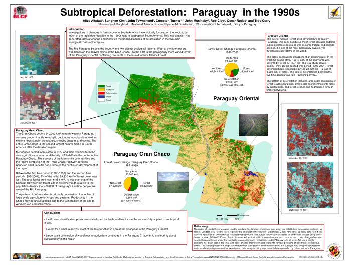
Forest Cover Change Paraguay Oriental 1989-2001. Study Area 98,622 km 2. Nonforest 67,544 km 2. Forest 22,109 km 2. May 14, 1985. Deforestation 8,968 km 2 (28.9% loss of forest). Forest. Nonforest. Deforestation. Water. Cloud. January 23, 1997. November 18, 1991.

E N D
Forest Cover Change Paraguay Oriental 1989-2001 Study Area 98,622 km2 Nonforest 67,544 km2 Forest 22,109 km2 May 14, 1985 Deforestation 8,968 km2 (28.9% loss of forest) Forest Nonforest Deforestation Water Cloud January 23, 1997 November 18, 1991 Forest Cover Change Paraguay Gran Chaco 1985 -1999 Study Area 133,206 km2 Nonforest 57,028 km2 Forest 69,320 km2 Deforestation 6,858 km2 (9% loss of forest) September 18, 2001 Subtropical Deforestation: Paraguay in the 1990s Alice Altstatt1, Sunghee Kim1, John Townshend1, Compton Tucker1,2, John Musinsky3, Rob Clay4, Oscar Rodas4 and Troy Curry1 1University of Maryland, 2National Aeronautics and Space Administration, 3Conservation International, 4Guyra Paraguay Introduction Investigations of changes in forest cover in South America have typically focused on the tropics, but much of the rapid deforestation in the 1990s was in subtropical South America. This investigation has generated rates of change and identified the principal causes of deforestation in the two main ecological zones of Paraguay. The Rio Paraguay bisects the country into two distinct ecological regions. West of the river are dry woodlands on the alluvial plains of the Gran Chaco. To the east is the geologically more varied terrain of the Paraguay Oriental containing remnants of the humid Interior Atlantic Forest. Paraguay Oriental The Interior Atlantic Forest once covered 85% of eastern Paraguay. This semi-deciduous moist forest contains endemic subtropical tree species as well as some tropical and cerrado species. It is one of the most biologically diverse, yet threatened ecosystems in the world. This forest continues to disappear at an alarming rate. In the first time period (1987-1991), 32% of the study area was covered by forest (31,077 km2 of a total study area of 98,622 km2). By the second time period (1999-2001), forest cover had been reduced by 29% to 22,109 km2 - a loss of 8,969 km2 of forest. The rate of deforestation between the two time periods was 700 – 900 km2 per year. The pattern of deforestation includes large scale conversion of forest to agricultural use, small scale encroachment into forest by campesinos, and forest clearing and degradation through timber harvesting. Paraguay Oriental Paraguay Gran Chaco The Gran Chaco covers 240,000 km2 in north-western Paraguay. It contains predominantly xerophytic deciduous woodlands as well as riverine forests, palm woodlands, shrubby steppes and cactus. The entire Gran Chaco is the second largest natural biome in South America after the Amazon region. Mennonites settled in this area in 1927 and their colonies form the core agricultural area around the city of Filadelfia in the center of the Paraguay Chaco. The success of the Mennonite communities and the recent completion of the Trans Chaco Highway between Asuncion and Filadelfia has promoted the continued development of the region. Between the first time period (1985-1990) and the second time period (1996-2001), 9% of the initial 69,230 km2 of forest cover was lost. The total forest area loss, 6,858 km2, is less than that of the Oriental. However the forest loss is extremely high relative to the population density. Only 80,000 of Paraguay’s 4 million people live west of the Rio Paraguay. The pattern of deforestation is primarily conversion of woodland to large scale agriculture for crops and pasture. Productivity in the Chaco may be unsustainable due to the vulnerability of the soil to wind erosion and salinization. Paraguay Gran Chaco Conclusions • Land cover classification procedures developed for the humid tropics can be successfully applied to subtropical areas. • Except for a small reserves, most of the Interior Atlantic Forest will disappear in the Paraguay Oriental. • Large scale conversion of woodlands to agriculture continues in the Paraguay Chaco amid uncertainty about sustainability in the region. Methodology Nine pairs of Landsat scenes were used to produce this land cover change map using our established processing methods. A recent Landsat ETM+ scene is co-registered to an ealier orthorectified TM EarthSat Geocover scene. Spectral data from both dates is input into an unsupervised isoclustering algorithm. The output clusters are assigned to land cover classes using an in-house module, PClassV. Pixels of output cluster values that fall into more than one land cover or land cover change class are iteratively reprocessed under the isoclustering algorithm and reclassified under PClassV until all pixels fall into a single category. For each scene, the final land cover change thematic map is filtered to remove polygons of less than 4 contiguous pixels. The overlapping scene maps are checked for consistency, and then mosaiced into a single map. Image interpretation and classification is performed by experienced data analysts using supplemental data provided by collaborators in Paraguay. http://glcf.umiacs.umd.edu Acknowledgements: NASA Grant NAG5-9337 Improvements in Landsat Pathfinder Methods for Monitoring Tropical Deforestation and their Extension to Extra-Tropical Areas and NASA NCC5300 University of Maryland Land Cover Earth Science Information Partnership.