Download
1 / 24
240 likes | 345 Views
Naval Oceanographic Office WG/CSAB Satellite update. Bruce McKenzie Lamar Russell April 15 th 2009. Outline. Satellite data sources Satellite data products NPOESS data exploitation Future altimeters Glider Operations. NOAA (DATMS-U) AVHRR MetOp, N-17, N-18 HIRS MetOp, N-17, N-18

E N D
Naval Oceanographic OfficeWG/CSAB Satellite update Bruce McKenzie Lamar Russell April 15th 2009
Outline • Satellite data sources • Satellite data products • NPOESS data exploitation • Future altimeters • Glider Operations
NOAA (DATMS-U) AVHRR MetOp, N-17, N-18 HIRS MetOp, N-17, N-18 Jason- 2 OSTM MODIS AQUA NRTPE MODIS AQUA GOES direct readout FNMOC (DATMS-U) SSM/I EDR SSM/IS EDR WindSat JPL GDAC Jason-1 GODAE SST ESA Envisat Satellite Data Sources
NOAA (DATMS-U) AVHRR MetOp, N-17, N-18 HIRS MetOp, N-17, N-18 Jason- 2 OSTM MODIS AQUA NRTPE MODIS AQUA GOES direct readout FNMOC (DATMS-U) SSM/I EDR SSM/IS EDR WindSat JPL GDAC Jason-1 GODAE SST ESA Envisat Satellite Data Sources
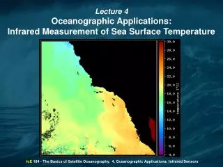
Satellite Data Products Ocean Feature Analysis Annotated AVHRR
NOAA (DATMS-U) AVHRR MetOp, N-17, N-18 HIRS MetOp, N-17, N-18 Jason- 2 OSTM MODIS AQUA NRTPE MODIS AQUA GOES direct readout FNMOC (DATMS-U) SSM/I EDR SSM/IS EDR WindSat JPL GDAC Jason-1 GODAE SST ESA Envisat Satellite Data Sources
Satellite Data Products Sea Surface Temperature Retrievals SST Field Polar orbiting global SST (9 km) Geostationary SST (12 km) Polar orbiting regional SST (2 km) Geostationary warmest pixel SST composite Global K10 composite
NOAA (DATMS-U) AVHRR MetOp, N-17, N-18 HIRS MetOp, N-17, N-18 Jason- 2 OSTM MODIS AQUA NRTPE MODIS AQUA GOES direct readout FNMOC (DATMS-U) SSM/I EDR SSM/IS EDR WindSat JPL GDAC Jason-1 GODAE SST ESA Envisat Satellite Data Sources
Satellite Data Products Sea Surface Height Anomaly Significant wave height Marine wind speed
NOAA (DATMS-U) AVHRR MetOp, N-17, N-18 HIRS MetOp, N-17, N-18 Jason- 2 OSTM MODIS AQUA NRTPE MODIS AQUA GOES direct readout FNMOC (DATMS-U) SSM/I EDR SSM/IS EDR WindSat JPL GDAC Jason-1 GODAE SST ESA Envisat Satellite Data Sources
Satellite Data Products Satellite Optics
NOAA (DATMS-U) AVHRR MetOp, N-17, N-18 HIRS MetOp, N-17, N-18 Jason- 2 OSTM MODIS AQUA NRTPE MODIS AQUA GOES direct readout FNMOC (DATMS-U) SSM/I EDR SSM/IS EDR WindSat JPL GDAC Jason-1 GODAE SST ESA Envisat Satellite Data Sources
Navy Coupled Ocean Data Assimilation (NCODA) Satellite Data Products Ocean Quality Control (OcnQC) system
NPOESS Data Exploitation • IPO has asked NRL SSC to take lead in Ocean calval • Initial meeting July 08 with following participants • Bob Arnone (lead) and Paul Lyons (NRLSSC) • Alexander Ignatov (NOAA/NESDIS) • Peter Minnett and Bob Evans (RSMAS) • Doug May and Bob Coulter (NAVO) • First priority is to get a proxy VIIRS data stream • Working with Joe Zajic (NOAA/IPO) on software that will ingest MODIS data and convert it to proxy VIIRS data in real-time • the data will be formatted according to the IDPS SDR output specification in HDF5 and will have the MODIS channels spectrally transformed to resemble VIIRS channels • Allows those users getting MODIS data already to run conversion software rather than acquiring another datastream • Will be used for both SST and ocean color NDE
Future Altimeter Satellite data Altika (2010 - 2014) * Considerable assistance required to allow access of data from Indian Space Organization (INSO) and/or CNES * Currently no MOU/MOA exists Sentinel 3 (2012 - 2016) * Spacecraft and data availability still under development * Establish MOU/MOA with ESA to receive data; similar to Envisat agreement GFO-2 (2013 – 2019) • Launch in highly successful GeoSat/GFO 17 day ERM • Final Requirement Specs – RFP release 4th quarter 2009 • Anticipated Contract Award – 2nd quarter 2010
OCEAN GLIDER PROGRAM Overview Distribution Unlimited
Ocean Glider Program SeagliderAPL/UW Spray Glider Scripps Institute of Oceanography Instrument Development Group Slocum Glider Webb Research Corporation Falmouth, MA Littoral Glider Alaskan Native Technology ANT - LG Spray Seaglider Slocum Weight 123 lb 110 lb 114 lb 200+ lb Hull Dia. 21 cm 30 cm 20 cm 31 cm Length 1.5 m 2.8 m (w/1-m antenna) 2.15 m 2+ m Horiz. Speed 0.6 knots 0.6 knots 0.6 knots 2+ knots Max Depth 200 m 1000 m 1500 m 200 m Theoretical - Endurance 15 - 30 days 6 months 4 months 30 days Range 600 - 1500 km 4000 km 3500 km 1500 km Propulsion Alkaline Lithium Lithium Alkaline Energy Comms(global) Iridium Iridium Iridium Iridium
Ocean Glider Program • MISSION: • LAUNCHED & RECOVERED FROM NAVAL SURFACE PLATFORMS SUPPORTING ENVIRONMENTAL DATA COLLECTION REQUIREMENTS DURING MILITARY SURVEYS, • OPERATIONS, AND/OR EXERCISES. • CONTROLLED BY NAVOCEANO GLIDER OPERATIONS CENTER PILOTS. • INCREASES DATA COLLECTION OPPORTUNITIES. • OPTIMIZES OCEANOGRAPHIC FEATURE CHARACTERIZATION. • PROVIDES NEAR-REAL TIME OCEANOGRAPHIC DATA FOR ASSIMILATION INTO DYNAMICAL MODELS AND FLEET TDAS. Approved for Public Reease – Dstribution Unlimited
Ocean Glider Program • COMMAND/CONTROL: • COMMON COTS HARDWARE/SOFTWARE COMPONENTS • - DISA APPROVED • - DATA ENCRYPTION/DE-ENCRYPTION, IF REQUIRED • - DATA CONVERSION TO SCIENTIFIC UNITS • COMMON USER INTERFACE • - GLMPC SOFTWARE • STANDARD” OUTPUT DATA FORMAT: • - BUFR • COMMUNICATIONS • - IRIDIUM FOR GLOBAL COMMUNICATION
Ocean Glider Program • CONDUCTIVITY • > RANGE: 0-9 S/M • > ACCURACY: 0.003 S/M (0.4 PPM) • TEMPERATURE • > RANGE: -5 TO +35ºC • > ACCURACY: 0.002ºC • DEPTH > 0 –200M (SHALLOW) > 0 – 1000M (DEEP) CURRENTS > INDIRECT MEASUREMENT • OPTICS • > MULTISPECTRAL BACKSCATTER > ATTENUATION • ACOUSTICS • > AMBIENT NOISE >ACOUSTIC MODEMS (INTERROGATION OF BOTTOM SENSORS)
Ocean Gliders: Persistent Unmanned Ocean Data Collection Capability from NAVOCEANO QUAD Chart 9/16/08 Mission:Remote Persistent Oceanographic Data Sampling (> 30 day durations) Current NAVOCEANO inventory: >8 Seagliders, 3 Slocums, 1 Spray. >1 additional Slocum, 1 Spray glider, and 4 additional Seagliders are scheduled to arrive NAVOCEANO O/A 10/08 Seaglider Spray Slocum System = Ocean Gliders (3 variants currently used) + Deployment / Recovery Platform + Shore Based Glider Operations Center (GOC) Activity System Highlights: • Capability developed by ONR research community to support • oceanographic research, transition to NAVOCEANO has occurred, • transition for fleet operational use in planning process • Typical data collection includes ocean temperature, salinity, optical • scattering, and current measurements • Deployed from surface platforms by two men • Once in the water fully autonomous • Data reported remotely by satellite to NAVOCEANO GOC • Missions & Way Points reprogrammable remotely • Long Endurance (30 days or more depending on glider type, sensors, and • environment) • 24 Hours/day capable • Low Observable, only on surface for brief periods to transmit data and • obtain GPS fix and data transmission. Number of Flights 6515 total dives * 2 profiles per dive, up/down • Many successful deployments have been demonstrated by the academic community over the last 10 years world wide • NAVOCEANO Glider Operations Center Activity (FY07 – FY08):