Download
1 / 36
360 likes | 449 Views
GPS snow sensing: results from the EarthScope Plate Boundary Observatory. Kristine Larson, Felipe Nievinski Department of Aerospace Engineering Sciences University of Colorado at Boulder. Why this paper?. Non-standard GPS application Multipath application Implications for

E N D
GPS snow sensing: results from the EarthScope Plate Boundary Observatory Kristine Larson, Felipe Nievinski Department of Aerospace Engineering Sciences University of Colorado at Boulder
Why this paper? • Non-standard GPS application • Multipath application • Implications for • Expanded / novel applications of NGS CORS • “one NOAA” … snow and soil moisture = water cycle
Outline • Multipath / reflections basics • Specifics of snow sensing technique • How it’s done • Why it’s useful • Paper overview • Tie in to NOAA / NGS work that could be done with CORS
Definition of some terms • Multipath: signal travels by multiple paths • SNR: signal-to-noise ratio (one type of GPS observable, derived from phase tracking; sensitive to phase multipath) • PBO: Plate Boundary Observatory (CORS-type network for plate tectonics) • SNOTEL: network of in situ snow sensors (truth measure for snow) • PRN: pseudorandom noise code (satellite ID number)
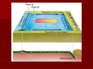
GPS Multipath • Satellite signals become a plane wave by the time they reach Earth’s surface. • Some ray paths are received by antenna on the ground: • Direct path • After bouncing off objects
GPS Multipath – SNR from simple ray tracing Pd Pr Slide modified from K Larson
GPS Multipath : remove direct + gain pattern Ignore the direct 10 deg Elevation Angle 30 deg Analyze only the multipath part of SNR Slide modified from K Larson
Each rising or setting GPS satellite samples a ground track Interference pattern in SNR data Slide courtesy of K Larson
P101 (Utah) Snow Depth/Height estimate reflector heightfrom frequency of interference pattern Slide courtesy of K Larson
Snow Depth/Height sensing footprint (Fresnel zone) also changes with snow height • Fresnel zone = function of • Height above surface • Elevation angle of satellite
Result: 20 observations per day (maximum) Sampling area: ~1000 m2 Specular reflection point (bounce point off of snow/ground) Slide modified from K Larson
Spatial resolution 10 m2 SNOTEL cm3 soil moisture probes 1000 m2 GPS 10-50 km Satellite missions
Terrain Slope Effect Error in snow depth < 2-5 cm for ground slopes of 8 degrees or less
P101(works great) Local slope calculations show low-angle terrain to NW and due S Terrain is wide open, no trees.
P101… most of the time Complex reflections to the NE, observed with PRN31. not all satellite tracks at a station will work equally well
P360 (also pretty good) Absence of data makes peak overly wide Site is very flat over the sensing zone Open scrubland
P711 (where are the wiggles?) Sometimes a station is “great on paper” but other factors will override potential signal … Lots of trees in the sensing footprint Overwhelms the relatively flat terrain…
P720(nada) Trees, trees and more trees
How to make a snow depth time series • Pick satellite tracks (strong LSP peaks) • Analyze rising and setting separately (different hunks of ground) • Get ground height from summertime data • Every day • Peak LSP (LSP height minus ground height = snow depth) • Average all good satellites into site mean (scatter of satellites = error bar)
Snow Depth Over 2 Years 15 km apart Wyoming Idaho 15 km apart Utah
Snow Depth Over 2 Years Wyoming Idaho Utah
Cautionary Tale: SNR data quality P101 Trimble NetRS Not all GPS receivers / data types provide good SNR! • Breaking the multipath “rules” • Poor resolution (firmware) PRN25 vs time L2C, PRN25 L1C, PRN25 L2P, PRN18 L2C with 1.0 dB resolution
CORS case study: MNDOT Network • All Trimble receivers • Operating at 5-sec rates • Mix of • NetRS • NetR3 • NetR5 • NetR9 • Stations often next to farm fields • Asked VRS operator to turn on L2C in January 2011 • COOP stations across state • Home of SNOWDAS
ASHL Looking West
To integrate CORS into PBO H2O • Collect SNR data • Evaluate SNR quality of non-Trimble receivers (Leica, Topcon, etc) • Varies by model, firmware release • Varies for phase observable (L1C, L2C, L2P, L5) • Manually sort stations • Exclude 100% urban • Flat terrain • Find rural, or semi-rural (side of building next to field) Good Not Good
Measure of signal strength for each satellite Total SNR = direct plus reflected signal(s) Direct amplitude = dominant trend Multipath signal = superimposed on direct Signal-to-Noise Ratio (SNR)
Multipath:One man’s error is another man’s signal • Multipath = direct + reflected signals • Error: increases apparent distance from satellite • Signal: amplitude and phase of GPS signal affected by reflecting surface
Multipath Geometry amplitudes angles h reflector distance angle of reflection satellite elevation angle path delay Addirect signal amplitude Ammultipath signal amplitude
Simplified Multipath Model and SNR multipath composite • Recorded SNR = direct + multipath signal • Carrier phase error: • Code (pseudorange) error (short delay): direct MP composite direct multipath
What do these equations tell us? • Oscillations in SNR, phase MP, and pseudorange MP all have common frequency • MP frequency • Key to determining • Function of • Reflector distance h • Reflection angle • GPS wavelength Fast MP = far away Slow MP = nearby For a fixed reflector, satellite motion generates time-varying signature
SNR, after removing direct signal Wiggles… • Sinusoidal • Result from interference of direct and reflected signals • Repeat daily • Have amplitude, frequency, and phase sensitive to soil moisture