Download
1 / 35
400 likes | 826 Views
Bulgaria. Georgia. Black Sea. Kyrgistan. Turkey. Greece. Pontic. Mt. Ararat. Armenia. Azerbaijan. Uzbekistan. Turkmenistan. Anatolia. Turkey. Azerb. China. Caspian Sea. Taurus. Tajikistan. Kopet. Fertile Crescent/ Mesopotamia. Tigris R. Khyber Pass. Elbruz. Syria. Cyp.

E N D
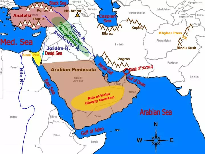
Bulgaria Georgia Black Sea Kyrgistan Turkey Greece Pontic Mt. Ararat Armenia Azerbaijan Uzbekistan Turkmenistan Anatolia Turkey Azerb. China Caspian Sea Taurus Tajikistan Kopet Fertile Crescent/Mesopotamia Tigris R. Khyber Pass Elbruz Syria Cyp. Euphrates R. Leb Med. Sea Afghanistan Iran Iraq Jordan R. Hindu Kush Jordan Israel Dead Sea Sinai Pen. Zagros Kuwait Pakistan Arabian Peninsula Strait of Hormuz Egypt Persian Gulf Libya Nile R. India India Q Saudi Arabia Gulf of Oman UAE Red Sea Oman Rub al-Kahli (Empty Quarter) Arabian Sea Yemen Eritrea Sudan Gulf of Aden Dj Ethiopia Somalia
Strait of Gibraltar Suez Canal Greece Spain Turkey Syria Med. Sea Atlantic Ocean Atlas Mtns. Iraq Tunisia Morocco Israel Jordan Sinai Pen. Algeria Sahara Desert Libya Saudi Arabia Nubian Desert Egypt Western Sahara Lake Nasser AhaggarMtns. Mauritania Nile Mali Red Sea Niger Chad Yemen Sudan Eritrea Ethiopia
Landforms Mountains • Cover Turkey, Iran and Afghanistan • Turkey: Source of Tigris and Euphrates • Mt. Ararat (Eastern Turkey) – Possible location of Noah’s Ark? • Afghanistan/Pakistan: Hindu Kush & Khyber Pass • Big enough to limit movement and weather • N. Africa • Atlas Mountains: ‘Extension’ of the Appalachian Mountains • Ahaggar Mountains: Middle of Sahara Desert
Rivers • Tigris and Euphrates • Area known as the “Fertile Crescent” and “Mesopotamia” • Origins of modern civilization • Origins of domesticating cattle, sheep, goats and pigs • Jordan River • Border of Israel and Jordan • Main water source for both • Feeds the Dead Sea • Lowest point on Earth (1,339 ft. below) • High salt content; water is 30% salt!! (no fish) • No outlet (endorheic lake: dead end)
Nile River • World’s longest = 4160 miles (NY LA = 2462) • Fed by Lake Victoria and Ethiopian Highlands • Flows S N • 95% of Egyptians live along Nile • Transportation, water source, soil deposits for farmland • Floods with winter rain and snow melt • Aswan High Dam = stops flooding, makes electricity • BUT…Stops new soil deposits • Creates Lake Nasser = World’s 2nd largest man-made lake • Hippos and crocodiles= dangerous to humans
21.4 ft., 2400 lbs 11 – 16 ft., 1100 lbs
Deserts • General facts: • Very little rain: <1.5 inches per year • Shifting sand; sandstorms • Temp swings: 30° - 120° • Water usage limited to rivers or desalinization • Some oases • Sahara Desert • World’s largest desert (bigger than US!) • Some sandstorms blow sand across the Atlantic!
Arabian Peninsula • Desert covers Peninsula up into Iraq • Southeastern part = Empty Quarter (Rub’ al Khali) • Depressions and basins • Some 400 ft. below sea level; 5000 ft. below surrounding area
Resources Farming • Only in river valleys, or near rivers • Jordan River Valley, Nile River, Fertile Crescent • Saudi Arabia = center pivot irrigation • Most is personal farming • Commercial farming is biggest in Israel & Egypt • Figured out a way to irrigate large land areas • Soil is very sandy: not good for growing
Oil • #1 resource • Found along the shores of the Persian Gulf and up into Iraq • Most is sold for export • U.S. is one of their biggest customers • OPEC: Organization of the Petroleum Exporting Countries Iran, Iraq, Kuwait, Saudi Arabia, Qatar, UAE, Algeria, Libya • Controls the amount of production and sale of oil • On 75% of world’s total oil; ~40% of world’s output • Also includes Venezuela, Nigeria and Indonesia
How much oil? Saudi Arabia • Produces up to 8.5 million barrels of oil per day • 1 barrel = 42 gallons = 357,000,000gallons! $83.80/barrel = $712,300,000
Water • Most important natural resource • Limited supplies: • Aquifers • Very old (145 million years ago) • Limited: not renewable once they are tapped out • Used for agriculture and human consumption • Rivers • Tigris, Euphrates, Jordan, Nile • Desalinization • Only used for human consumption
Water in Saudi Arabia • Surface water = 10% of total used • Groundwater in aquifers = 84% of total used • Water from deep wells (~3000 ft. deep!) • 70% of drinking water is desalinized • 27 desalinization plants • Plants also generate electricity • Pipe desalinized water 290 miles to Riyadh • Other sources for Riyadh = rainwater dams