Download
1 / 51
540 likes | 554 Views
Chapter 3 Geology of the Ocean. Key Concepts. The world ocean has four main basins: the Atlantic, Pacific, Indian, and Arctic. Life first evolved in the ocean. The earth ’ s crust is composed of moving plates.

E N D
Chapter 3 Geology of the Ocean
Key Concepts • The world ocean has four main basins: the Atlantic, Pacific, Indian, and Arctic. • Life first evolved in the ocean. • The earth’s crust is composed of moving plates. • New seafloor is produced at ocean ridges and old seafloor is removed at ocean trenches.
Key Concepts • The ocean floor has topographical features similar to those found on continents. • The seafloor is composed of sediments derived from living as well as nonliving sources. • Latitude and longitude determinations are particularly necessary for precisely locating positions in the open sea, where there are no features at the surface.
World Ocean • Primitive earth and formation of the ocean • early earth thought to be composed of silicon compounds, iron, magnesium oxide, and other elements • gradually, the earth heated, causing melting and separation of elements • water vapor locked within minerals worked its way to the surface, where it cooled, condensed, and formed the ocean
World Ocean • Ocean and the origin of life • atmosphere formed by gases escaping from deep within the planet • free oxygen formed oxides, oxygen did not accumulate until evolution of modern photosynthesis • Stanley Miller’s apparatus demonstrated that simple organic compounds could have been formed under conditions present on primitive earth
World Ocean • The ocean today • 4 major ocean basins: • Pacific • Atlantic • Indian • Arctic • Pacific Ocean - largest • Arctic Ocean - smallest • Seas - smaller than ocean, essentially landlocked
Continental Drift • Layers of the earth • Inner core: solid, iron- and nickel-rich • Outer core: liquid (same composition) • Mantle: thickest layer with greatest mass, mainly magnesium-iron silicates • Crust: thinnest and coolest, outermost • Lithosphere: crust and upper mantle • Asthenosphere: region of mantle below the crust
Continental Drift • Moving continents • Alfred Wegener • Continents fit together like pieces of jigsaw puzzle • One supercontinent - Pangaea • Laurasia and Gondwanaland
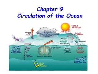
Continental Drift • Forces that drive continental movement • magma moves by convection currents • midocean ridges - form along cracks where magma breaks through the crust • at subduction zones, old crust sinks into the mantle where it is recycled • seafloor spreading causes continental drift
Continental Drift • Evidence for continental drift • fit of continental boundaries • earthquakes • seafloor temperatures highest near ridges • age of crust, as determined by samples drilled from the ocean bottom, increases with distance from a ridge
Continental Drift • Theory of plate tectonics • lithosphere is viewed as a series of rigid plates separated by earthquake belts • divergent plate boundaries: located at midocean ridges where plates move apart • convergent plate boundaries: located at trenches where plates move toward each other • faults: regions where plates move past each other (e.g. transform faults) • rift zones: where lithosphere splits
Continental Drift • Rift (Deep Sea Vent) Communities • depend on specialized environments found at divergence zones of the ocean floor • first discovered by Robert Ballard and J.F. Grassle in 1977, in the Galápagos Rift • primary producers are chemosynthetic bacteria
Ocean Bottom • Bathygraphic features • Geological features similar to land: mountain ranges; canyons, valleys; great expanses • Continental margins • continental shelf, continental slope, and shelf break • Submarine canyons • Continental Rises • Shaping Continental Shelves
Sediment from beach erosion Sediments Wave-cut terrace Continent Continental rock Coral reef, volcano, or island Water-deposited sediment River River sediment Continental rock Continental rock Subsurface rock Stepped Art Fig. 3-12, p. 56
Ocean Bottom • Ocean basin • abyssal plains and hills • seamounts • ridges and rises • trenches and island arcs • Life on the ocean floor • continental shelves are highly productive • life on the abyssal plains is not abundant, no sunlight, no photosynthesis
Composition of the Seafloor • Sediment—loose particles of inorganic and organic material
Composition of the Seafloor • Hydrogenous sediments • formed from seawater through a variety of chemical processes • e.g. carbonates, phosphorites, manganese nodules • Biogenous sediments • formed from remains of living organisms • mostly particles of corals, mollusk shells, shells of calcium carbonate or silicious planktonic organisms
Composition of the Seafloor • Terrigenous sediments • produced from continental rocks by the actions of wind, water, freezing, thawing • e.g. mud (clay + silt) • Cosmogenous sediments • iron-rich particles from outer space, land in the ocean and sink to the bottom
Finding Your Way around the Sea • Maps and charts • Mercator projections • bathymetric charts • physiographic charts
Finding Your Way around the Sea • Reference lines • latitude • longitude • divisions of latitude and longitude
Finding Your Way around the Sea • Navigating the ocean • principles of navigation • a sextant was used to determine latitude based on the angle of the North Star with reference to the horizon • longitude determined using chronometer
Finding Your Way around the Sea • Navigating the ocean • Global Positioning System (GPS) • utilizes a system of satellites to determine position • GPS measures the time needed to receive a signal from at least 3 satellites, and calculates position