Download
1 / 9
90 likes | 245 Views
Air Quality and Health Scenario. Stefan Falke, Rudy Husar, Frank Lindsay, David McCabe. Air Quality & Health. Focus Areas Real-Time Large-Scale Event Analysis Assessment of Intercontinental Transport Air Quality Forecasting Information to the Health Community & the Public

E N D
Air Quality and Health Scenario Stefan Falke, Rudy Husar, Frank Lindsay, David McCabe
Air Quality & Health Focus Areas Real-Time Large-Scale Event Analysis Assessment of Intercontinental Transport Air Quality Forecasting Information to the Health Community & the Public Key Actors: Data Providers, Analysts, IT, AQ Decision Makers • AIP Participants represent diverse group with multiple perspectives • Stakeholders: IT System Users, Data Providers, Funding Agencies, Developers, Researchers Challenges • Persistent, standardized AQ data network • Interface to GCI: Community Catalog, Portal • Selecting a scenario which can integrate the offerings using GCI-compatible Service Oriented Architecture
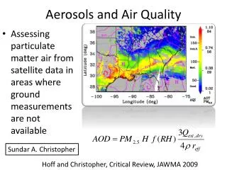
Scenario Overview • The air quality scenario describes how the air quality community will use an interoperable, service-oriented system-of-systems which makes available and adds value to a wide variety of Earth observations, including • satellite observations of air quality and meteorological • in-situ observations of ambient conditions, primarily surface measurements of concentrations, visibility, etc. • models of meteorology and chemical transport models • emissions data, fire observations (i.e. from satellites), LIDAR, and other relevant observations. • An important theme is that, in general, none of these data sources are adequate for decision support by themselves. • The scenario envisions that service-oriented software and data components and services, found and accessed through GEOSS, will enable analysts to fuse models and disparate observations to arrive at improved estimates of current air quality conditions, forecasts, and historical trends. • These value-added, synthesized Earth observations in turn improve decision support.
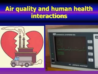
Who do the air quality scenarios benefit? The scenario is structured around the needs of three end-users: • A policy-maker, needing synthetic assessments of long-range transport of air pollution • An air quality manager, assessing whether an episode qualifies as an ’exceptional event’ under AQ regulations Exceptional events such as fires, dust storms are not counted as an exceedance under AQ regulations. In US, petitioners can use any applicable data to show exceptionality of an event. • The public, needing information on air quality now and tomorrow Enables individuals, families to adjust plans if air quality is/will be poor; allows health community, other decision-makers to plan for episodes
Wildfire and Smoke Scenario Smoke from wildfires impacts air quality conditions both near fires and at locations hundreds of miles away, through smoke transport. Air quality managers, public health officials, and the public rely on information about wildfires, smoke, and air pollution concentrations in order to make decisions during the event to protect the safety and health of the public. After the event, AQ analysts use synthesized earth observations to improve the characterization of smoke events. Their analyses support decision making for air quality management, such as the analyses of exceptional events and long-range pollution transport mentioned above. The goal of this scenario is to improve the sharing and usability of Earth observation data relevant to wildfire smoke to support air quality management and public health decision making. Scenario is available as a shared Google Doc
0 Fires are detected through satellite and surface observations, activating alert systems for automatic notifications 1 Air quality analysts, modelers and public health officials receive automated notification of the new fires and where the data are available 2 Fire data sources are accessed for particular locations and times 3 Based on fire locations, smoke forecasts are run to predict downwind impacts 1-3 days in the future which indicate a regional smoke pollution event 4 Multiple smoke forecast products are accessed by air quality managers and analysts 5 Multiple smoke observation products are accessed by air quality managers and analysts 6 The air quality manager/analyst spatially and temporal compares and analyzes differences and similarities in the forecast products 7 The public health officials uses the smoke forecast analysis to issue public health alerts 8 The air quality manager/analyst uses the smoke forecast analysis to anticipate “exceptional event” waiver requests by States 9 After the smoke event, the air quality manager/analyst conduct retrospective spatial-temporal analyses of forecast and observation data (from satellite, aerial and surface sensors) to improve knowledge of smoke’s impact on air quality 10 The air quality manager/analysts uses multi-source observation data to determine whether to approve of “exceptional event” waiver requests. Scenario Steps
Context and Pre-Conditions • Fires are detected through satellite and surface observations and made available through GEOSS • Forecast model output is available through GEOSS • Data from the smoke event are available for retrospective analyses • Surface particulate matter concentrations are available through GEOSS • Satellite derived spatial smoke extent and parameters (e.g., Aerosol Optical Depth) are available through GEOSS • The actors are familiar with the datasets, know how to access them and have worked with them previously.
Post Conditions • New fire and smoke observations are available to GEOSS • New smoke forecasts are available to GEOSS • Improved exceptional event decisions • Improved smoke event alerts