Download
1 / 38
400 likes | 516 Views
Phase I ESA. Environmental Site Assessment. Purpose. The purpose of this phase I ESA is to provide professional opinion on the potential hazardous substances that are on site 140-156 E. 14 th st. (Parcel A). Detailed Scope-of-Service.

E N D
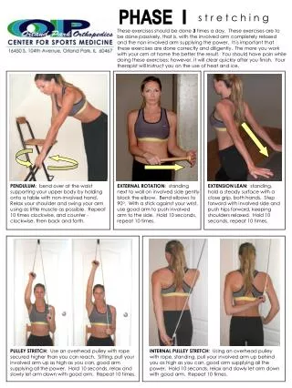
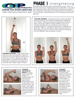
Phase I ESA Environmental Site Assessment
Purpose • The purpose of this phase I ESA is to provide professional opinion on the potential hazardous substances that are on site 140-156 E. 14th st. (Parcel A)
Detailed Scope-of-Service • Conducting a regulatory database search Of known underground storage tanks and land fills. • Hazardous waste generation or treatment • Storage and disposal facilities • & Surface contamination.
Significant Assumptions • There are no assumptions that apply to this site.
Limitations and Exceptions • Noapparent limitations that would limit the ability to complete the scope work.
Special Terms and Conditions • There are no special terms and conditions that apply.
User Reliance • Reports shall not be relied upon by or transferred to any other site. • Phase I ESA report has been prepared for use solely by COCH.
Location and Legal Description • The property is located along the south and the east of 14th st.
Subject Property and Vicinity Characteristics • Adjacent properties including residential and commercial properties. • Property was vacant at the time of site reconnaissance.
Physical Settings • The soil surface layer has black silty clay loam. • No wetlands were identified. • Property was not located in flood zones
Descriptions of Structures, Roads, and Other Improvements • Vacant property • With Grassland • Paved sidewalks
Current Adjoining Property Uses • Identify potential environmental concerns. • Properties was were observed from the boundaries and public right-a-ways
Title Records • URS was not provided with title insurance reports for the subject properties.
Environmental Liens Use Limitations • EDR was not able locate the property • Environmental liens reports was not provided to URS.
Specialized Knowledge • No specialized knowledge beyond what was discussed throughout the reports • It was conveyed to URS during the preparation of the report
Owner, Site Manager, and Occupant Information • Subject property was obtained in tax reclaimation
Reason for ConductingPhase I ESA • The subject property is owned by COCH.
Other Information • URS was provided with eligibility determination for Brownfield assessment. • Parcel A contained S&D Body Shop
Standard Environmental Records • Subject was not listed in any database searched by the EDR
Additional Environmental Records • URS attempted to conduct file reviews at a applicable state, municipal and county offices.
Historical Use • Developed since at least 1929 • Two square buildings on the northeast and northwest
Aerial Photographs • Due to poor quality structures were difficult to disconcern
Topographic Maps • Review maps of Calumet City and Harvey
Sanborn Fire Insurance Maps • Sandborn maps were reviewed for the subject property provided form the EDR • Dated 1911, 1950 1966,1975
City Directories • City directory search was only conducted for the subject property address 284 E 14th Street
Methodology and Limiting Conditions • Clear and 30 degrees Fahrenheit no limitations
Interior and Exterior Observations • Vacant and grassed at the time • Mounds of garbage found at the site
Hazardous Substances and Petroleum Products • Not observed at the subject property
Underground/ Aboveground Storage Tanks • No evidence of UST’s or AST’s at the site
Drains and Sumps • No drains or sumps were observed • Storm water is managed by street flow or surface infiltration. • The site area surrounding roadways and the municipal combined sewer system
Waste Water • No process or sanitary waste water is generated on site • Storm water flows to Storm drains located in the adjacent streets
Utilities • As the subjects property is vacant, utilities are not provided.
Wells • No wells were observed or reported on or adjacent to the subject property during reconnaissance. • Site contacts were not aware of wells at the subject property.
Pits, Ponds, Lagoons • No pits, ponds or lagoons were observed on the subject property during the property visit.
PCB-Containing and Hydraulic Equipment • Five pole mounted transformers at the site • Owners not known
Other Physical Evidence of Contamination • No other physical evidence of contamination was observed on the subject property during URS site reconnaissance with the exception of scattered debris that’s observed on the subject property.
Conclusions • The historical uses of are considered REC’s • Parcel A
Environmental Professionals Involved • Stacy McCance • Sarah Ruben