Download
1 / 26
260 likes | 273 Views
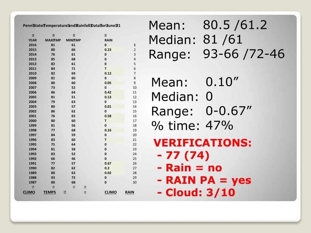
80.5 /61.2 81 /61 93-66 /72-46. Mean: Median: Range:. 0.10” 0 0-0.67” 47%. Mean: Median: Range: % time:. VERIFICATIONS: - 77 (74) - Rain = no - RAIN PA = yes - Cloud: 3/10. NAM MODEL – Precip . map Totals (2 pm – 8 pm) (18z – 00z). GFS MODEL – Precip . map

E N D
80.5 /61.2 81 /61 93-66 /72-46 Mean: Median: Range: 0.10” 0 0-0.67” 47% Mean: Median: Range: % time: VERIFICATIONS: - 77 (74) - Rain = no - RAIN PA = yes - Cloud: 3/10
NAM MODEL – Precip. map Totals (2 pm – 8 pm) (18z – 00z) GFS MODEL – Precip. map Totals (2 pm – 8 pm) (18z – 00z)
Penn State Weather Camps Basic Weather Forecasting Guidelines • Sat I – Sat II – Sat III – Sat WV - NWS - NHC – Radar - Radar • sfc. map 1 - sfc. map 2 – sfc map 3
Cindy does not look much like a tropical cyclone on satellite images this morning, however, dramatic changes have just occurred in the last 30 minutes! The deep convection is well-removed to the north and northeast of an exposed low-level center, and there is a rather linear north-south band of convection several hundred miles east of the center. Water vapor imagery indicates that an upper-level low is located a couple of hundred miles to the northwest of Cindy's center, suggesting that the system has at least some subtropical characteristics.
Cindy does not look much like a tropical cyclone on satellite images this morning. (however, dramatic changes have Occurred in the last 30 minutes!) The deep convection is well-removed to the north and northeast of an exposed low-level center, and there is a rather linear north-south band of convection several hundred miles east of the center. Water vapor imagery indicates that an upper-level low is located a couple of hundred miles to the northwest of Cindy's center, suggesting that the system has at least some subtropical characteristics.
The current intensity is held at 50 kt for this advisory, although surface observations and a recent ASCAT overpass suggest that this may be generous. Global model forecasts indicate significant shear, with some mid-level dry air wrapping around the circulation, over the next day or so. These factors, along with the current lack of convection near the center, should result in some weakening of the system prior to landfall, perhaps more so than indicated in the NHC forecast.
The initial motion estimate remains northwestward, or 310/7 kt. Cindy is expected to turn northward and move through a break in the mid-level subtropical ridge along the northwest Gulf of Mexico coast. • Later in the forecast period Cindy, or its remnant, should accelerate northeastward in the westerlies over the eastern United States. • The official track forecast is mainly a blend of the ECMWF and GFS and also leans toward the latest HFIP Corrected Consensus prediction.
The primary hazard from Cindy continues to be very heavy rainfall over portions of the central and eastern Gulf Coast, which could cause life-threatening flash flooding in some locations. • Antecedent conditions • FORECAST POSITIONS AND MAX WINDS • INIT 21/0900Z 27.3N 91.9W 50 KT 60 MPH • 12H 21/1800Z 28.0N 92.8W 50 KT 60 MPH • 24H 22/0600Z 29.3N 93.5W 45 KT 50 MPH • 36H 22/1800Z 30.9N 93.8W 35 KT 40 MPH...INLAND • 48H 23/0600Z 33.2N 92.8W 25 KT 30 MPH...INLAND • 72H 24/0600Z 36.0N 85.0W 20 KT 25 MPH...INLAND • 96H 25/0600Z...DISSIPATED
NAM MODEL – 4 panel fcst. Valid at 8 p.m. (00z) TODAY
NAM MODEL – sfc forecast Valid at 8 p.m. TODAY (00z)
NAM MODEL – 500mb fcst. Valid at 8 p.m. TODAY (00z) Trough
THUNDER TODAY ….. ARE YOU KIDDING ME ?!?!?!? LIFTED INDEX Valid 8 P.M. (00z)
CAPE (NAM) Valid 2 P.M. (18z)
CAPE (GFS) Valid 2 P.M. (18Z)
MOS – Model Output S … • Accu Friends • Wx Channel Friends • NWS Friends
Penn State Weather Camps Basic Weather Forecasting Guidelines • Sat I – Sat II – Sat III – Sat WV - NWS - NHC – Radar - Radar • sfc. map 1 - sfc. map 2 – sfc map 3
SURFACE PRESSURE ? ? ? ? ?
NH RH NL RL Know what to expect! = Climo.