Download
1 / 61
620 likes | 627 Views
CLIMATE. Day vs. Night. Earth rotates on it ’ s axis (24 hours). Results in day and night. Seasons. Earth revolves around the Sun (orbits 365 days). Results in seasons. Cloud Cover. Cloud Cover : Nightly cloud cover will result in less temperature range (like a blanket)

E N D
Day vs. Night • Earth rotates on it’s axis (24 hours). Results in day and night
Seasons Earth revolvesaround the Sun (orbits 365 days). Results in seasons
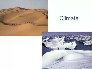
Cloud Cover • Cloud Cover: • Nightly cloud cover will result in less temperature range (like a blanket) • Without cloud cover, heat escapes (at night), but temperature range is very high (hot days, cold nights…the desert)
Differences in Day Length • The tilt of the earth’s axis combined with the earth’s rotation in orbit around the sun results in different day lengths. The difference? • In June: because of the tilt on the earth's axis, the north pole points towards the sun and receives more hours of exposure to the sun hence giving it longer days. • In December: because of the tilt on the earth's axis, the north pole points away from the sun and receives fewer hours of exposure to the sun hence giving it shorter days. SUN JUNE DECEMBER
SEASONS • The tilton the earth's axis and; • The revolution of the earth around the sun • These two features of the earth-sun relationship mean that different latitudes on earth receive different directness of light at different times.
Equinox and Solstice • Solstice: • sun is directly over head @ 12 noon on 23.5º North or South; • occurs Dec 21 & June 21 • longest day of the year & shortest day of the year. • Equinox: • sun is directly over head @ 12 noon on the equator; • occurs Sept. 21 & March 21 • equal length of night and day everywhere on earth.
Tropics vs. The Poles • The tropics are located between 23.5˚ north and 23.5˚ south(Cancer and Capricorn) • The further you move away from the tropics the more severe the seasons. • The length of day varies more the further you move from the equator. • When light hits the earth towards the poles it is on a severe angle which decreases the intensity of heat.
Greenhouse Effect • A good thing? • In moderation of course; moderates our temperatures • Without we would have extreme variation of temperatures between day and night • Atmosphere reflects and absorbs about 50% of radiant energy • Without atmosphere, planets have nothing to hold heat in (like the glass in a greenhouse… consequently the nights are not as cool)
Latitude and Temperature • The closer we get to the equator, the warmer it gets • “The further south one goes the warmer it gets” (FALSE). Once we went far enough south to go past the equator the temperatures would start getting colder again. • As latitude increases, temperature decreases
Other Factors • Prevailing Winds • Regular, predictable, normal wind direction. They are caused by global convection cells in the earth's atmosphere. • Ocean Currents • The biggest factor besides the sun. If the water is warm, the temperatures will be more moderate. • Altitude • the higher the altitude, the cooler it will be. • Rate is about 1˚ per 100m
WIND • Winds Blow From High Pressure to Low Pressure • Any real examples of this at work? • Air inside a balloon. If left untied the air will escape the high pressure of the balloon and create a wind blowing from high pressure (inside the balloon) to relatively low pressure (outside the balloon). • High and low pressures in the earth’s atmosphere are responsible for wind.
High vs. Low Pressure Low Pressure: Usually a result of “heating” High Pressure: Usually a result of “cooling”
Sea Breeze/Land Breeze • What heats faster; land or water? • When do things warm or cool over the course of 24 hours? • During the day the land heats much faster than the water; • Consequently the air over the land heats and rises (low pressure) while the air over the water/sea is relatively high; • Wind blows from the high pressure to the low pressure • Hence the name 'sea breeze'—the wind is blowing off the sea.
Convection Cells • The global convection cells are created because of the differential heating of the earth's surface. • Alternating high and low pressure belts result from the convection cells. • You want real results?
The results? Every desert in the world is found at a similar latitude Every rainforest of the world is found at a similar latitude. Coincidence?
Types of Rain • Three types of rainfall: • Relief Rain • Convectional • Frontal / Cyclonic Rain
Rain. Period. hot air rises warm moisture-laden air cools at higher altitude cool air holds less moisture; consequently clouds condense and rain falls.
Relief Rainfall • Moisture laden air blows off the sea; • Air is forced up by mountains (high relief) • Most rain falls on the windward side of the relief • Leeward side is often in a dry rain shadow because the moisture has all been lost.
Convectional Rainfall • Usually occurs in hot areas like tropics or continental summer (Winnipeg thunderstorms) • sun heats the earth causing large amounts of water to evaporate • Then what? • Remember RAIN.PERIOD. Check it out!
Frontal / Cyclonic Rainfall • Warm moist air meets cold air • Warm air is less dense & is forced up over the cooler, more dense air • Then What? • Fall/spring/some summer Winnipeg rains
Ocean Currents • Permanent horizontal movement of surface water (the top 100m) • It is unusually cold or warm, when compared with the surrounding water • Analogy: • Sun=CEO of climate • Ocean Currents=BOSS of climate
Where do they go? Where would you expect cool currents to start from? Where would you expect warm currents to start from? How do currents create balance in the world?
Warm and Cold Currents • Cold ocean currents: move water towards the equator. • For example the Humbolt or Peru Current carries cold water from Antarctica toward the equator. • Another example is the Labrador Current which carries cold water from the Arctic Ocean. • Warm ocean currents: Move water away from warm equatorial regions. • For example the Gulf Stream moves warm water from the Gulf of Mexico northeast toward England. • Another good example is the Japanese current which moves warm water from Japan northeast towards Vancouver.
Ocean Currents & the Affect on Climate • Affect of cold ocean currents Cools the summer temperature; Reduces precipitation; cooler air holds less moisture. • Affect of warm ocean currents Warms the winter temperature; Increases precipitation; warmer air holds more moisture. El Nino
Continentality • Temperature range: the difference between the highest and the lowest average monthly temperatures of a region. • What helps creates this range in this case? Proximity to ocean (or larger body of water) • Large or high temperature range: extremes of temperature, hot summer, cold winter (Winnipeg). • Small or low temperature range: moderated temperature, warm summer, cool winter (Victoria)
Continental vs. Maritime Climates • As distance from the ocean increases, annual temperature range increases. • Continental climates experience greater extremes of temperature than coastal climates at the same latitude. • The plains region of Saskatchewan, for example, experience a continental climate. The winter temperatures are very cold, and the summer temperatures are fairly hot. Range could be from: -40° to 40°C • Close to the ocean, Victoria experiences a much more moderate climate. Range is from: -5° to 25°. Not too cold, but at the same time, not too hot in the summer.
Climate Graphs • Give us a yearly climate snap-shot of a given place • Temperature will always be shown with a line graph • Precipitation will always be shown with bar graphs
Maritime • Scotland….
Continental • Winnipeg
Tropical Climates • All Tropical Climates have average temperatures over 18˚C every day • All Tropical climates can be divided into: a) Tropical Wet b) Tropical Wet and Dry • Almost all of the tropical wet / wet & dry climates are located between the tropic of cancer and the tropic of Capricorn (23.5˚ N and S).
Tropical Wet Climate • Tropical Wet : heavy rain all year due to hot temp & resulting convectional rain.
Tropical Wet and Dry Climate Tropical Wet& Dry: very heavy summer rain & very dry winter due to seasonal shift in prevailing winds. (monsoon regions)
Dry Climates • All Dry climates receive less than 500mm precipitation annually. • Dry Climates can be divided into: a) Arid b) Semi-Arid • more evaporation than precipitation = water deficit. • There is little vegetation & it is often windy
Arid or Desert Climates • Arid Climates: occur mostly between 10-30˚N & 10-30˚S and receive 10-250mm rain annually.
Semi-Arid Climate • Semi-arid Climates: are transition zones between Desert & Forest. They receive 250-500mm rain annually which is often enough to support grasses but not forests.
Temperate Climates • Usually in higher latitudes (above 30˚ N and S) • Temperate Climates can be divided into: • a)Temperate MildClimatesoccur in both hemispheres • b)Temperate Cold Climatesonly occur in the northern Hemisphere. (Winnipeg) • The distinguishing feature on a climate graph is the temperature line (yearly average Temp.)
Temperate Climates • Temperate Mild Winter • Temperature varies with seasons • Mid Latitudes • Mild winter • Summer temperatures vary but winters are warmer than –3ºC • Temperate Cold Winter • Temperature varies with seasons • Mid-high Latitudes • cold winters • Summer temperatures vary but winters are colder than –3ºC
Polar Climates • Polar climates are distinguished by their extremely low winter temperatures and low summer temperatures. • Polar Climates can be divided into: • Tundra: summer temperature never above 10˚C • Ice Caps: summer's average monthly temperature is never above 0˚C