Download
1 / 1
10 likes | 226 Views
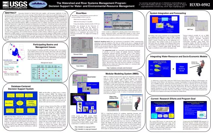
Hydromet Real-time climate data feed. Hydrologic Database. DMI. DMI. RiverWare Reservoir and River System Operations Model. DMI. MMI. Object User Interface Interface for data visualization and modeling. Modular Modeling System Precipitation/Runoff Model (PRMS). Water Rights.

E N D
Hydromet Real-time climate data feed Hydrologic Database DMI DMI RiverWare Reservoir and River System Operations Model DMI MMI Object User Interface Interface for data visualization and modeling Modular Modeling System Precipitation/Runoff Model (PRMS) WaterRights HydroPower WaterUse WaterQuality Drought &Floods GW/SW ESA Colorado&Gunnison Yakima UpperRio Grande Truckee Upper Columbia Currently Active Initial Issues Follow-on Issues Colorado Basin, Gunnison, Pecos, Upper Rio Grande, Truckee Water Banking Model Under Development San Juan, Umatilla, Upper Columbia Future Bitterroot, Carson, Central Platte, Lower Rio Grande, Salmon Model Builder GIS WEASEL MMS Interface Weather and Climate Forecasts Water Use Estimation Real-time Data Collection Modular Modeling System (MMS) RiverWare Hydrologic Database HDB Disseminate Information and Knowledge Interpretation of Information Quality Control Data Processing Analysis The Watershed and River Systems Management Program: Decision Support for Water- and Environmental-Resource Management H33D-0502 G. Leavesley (george@usgs.gov), S. Markstrom (markstro@usgs.gov), D. Frevert (dfrevert@do.usbr.gov), T. Fulp (tfulp@lc.usbr.gov), E. Zagona (zagona@cadswes.Colorado.edu), and R. Viger (rviger@usgs.gov) ABSTRACT– Increasing demands for limited fresh-water supplies, and increasing complexity of water-management issues, present the water-resource manager with the difficult task of achieving an equitable balance of water allocation among a diverse group of water users. The Watershed and River System Management Program (WARSMP) is a cooperative effort between the U.S. Geological Survey (USGS) and the Bureau of Reclamation (BOR) to develop and deploy a database-centered, decision-support system (DSS) to address these multi-objective, resource-management problems. The decision-support system couples the USGS Modular Modeling System (MMS) with the BOR RiverWare tools using a shared relational database. MMS is an integrated system of computer software that provides a research and operational framework to support the development and integration of a wide variety of hydrologic and ecosystem models, and their application to water- and ecosystem-resource management. RiverWare is an object-oriented reservoir and river-system modeling framework developed to provide tools for evaluating and applying water-allocation and management strategies. The modeling capabilities of MMS and RiverWare include simulating watershed runoff, reservoir inflows, and the impacts of resource-management decisions on municipal, agricultural, and industrial water users, environmental concerns, power generation, and recreational interests. Forecasts of future climatic conditions are a key component in the application of MMS models to resource-management decisions. Forecast methods applied in MMS include a modified version of the National Weather Service's Ensemble Streamflow Prediction Program (ESP) and statistical downscaling from atmospheric models. The WARSMP DSS is currently operational in the Gunnison River Basin, Colorado; Yakima River Basin, Washington; Rio Grande Basin in Colorado and New Mexico; and Truckee River Basin in California and Nevada. System Integration and Forecasting RiverWare • RiverWare is a general purpose reservoir and river system modeling tool that is used for • Short-term forecasting (12-48 hr) • Mid-term forecasting (1-12 months) • Long-term planning and policy studies (10-85 yrs) RiverWare was developed by the University of Colorado with funding from the Bureau of Reclamation and the Tennessee Valley Authority. Collaborators today include the US Army Corps of Engineers. It is maintained and licensed by the University of Colorado. User support and training are provided. ESP Tool A river system is configured by selecting generic basin features from a palette, naming the features, and linking them together to create a basin topology. Alternative physical processes can be selected for each feature. Forecast methods available for use in MMS include a modified version of the National Weather Service’s Ensemble Streamflow Prediction (ESP) procedure and statistical downscaling procedures using output from atmospheric models. The ESP Tool enables the viewing of all ESP forecast traces, the selection of specific traces, and the writing of the selected traces to HDB for use by RiverWare. The linking of all system components into an operational DSS is accomplished with HDB and a variety of DMIs. A Model Management Interface (MMI) is an XML script in OUI that defines a group of models that are run sequentially for a single purpose. Thus multiple models can be executed with one mouse click. For example, in the Gunnison River basin, 15 individual watershed models are run and their outputs are used as input to a channel routing model. Routing model output is available for view in OUI at all channel nodes. RiverWare can be run in pure simulation, rulebased simulation and optimization modes. Rulebased simulationmode allows the specification of prioritized “if-then” operating policy statements to drive the simulation. The rules are written by the user in a language provided through the syntax-directed editor. Complex policy can be represented by using a library of pre-defined or user-customized functions. Rules can be turned on and off and their level of priority can be changed to conduct “what if” scenarios. Participating Basins and Management Issues The development of modeling and DSS tools began with a 2-year program in the Gunnison River basin in Colorado. New basins with new modeling and resource-management issues were added every 2 years to facilitate the enhancement and testing of the system. New issues also evolved within study basins over the course of time. The current system is very robust and can be applied to a wide range of water- and environmental-management issues in a variety of climatic and physiographic regions. The optimization mode uses a preemptive goal programming approach to provide a tool for trading off multiple objectives. RiverWare automatically generates physical constraints, such as mass balance, topological connections, and upper/lower bounds from the constructed model. Prioritized policy objects and constraints are entered through a graphical constraint editor, and are automatically linearized. A linear program (LP) is generated for each goal and sent to the CPLEX solver. Objectives are met in order of priority, and the solution is returned to the objects. The LP solver treats each successive constraint as an objective, finding the best solution and setting that solution as a constraint while meeting lower-priority objectives. Ruleset Editor Integrating Water-Resource and Socio-Economic Models Middle Rio Grande Basin Management Issues Rule Editor + http://cadswes.colorado.edu/riverware/ Modular Modeling System (MMS) MMS is a modeling framework that supports the integration of models and tools at a variety of levels of modular design. Design levels include individual process models, tightly coupled models, loosely coupled models, and fully integrated decision support systems. A geographic information system (GIS) interface, the GIS Weasel, has been integrated with MMS to enable spatial delineation and characterization of basin and ecosystem features, and to provide objective parameter-estimation methods for selected models using available digital data coverages. Optimization and sensitivity-analysis tools are provided to analyze model parameters and evaluate the extent to which uncertainty in model parameters affects uncertainty in simulation results. A variety of visualization and statistical tools are also provided. A collaborative research effort among the USGS Science Impact Program, the Bureau of Reclamation, the University of New Mexico, the University of Arizona’s Sustainability of semi-Arid Hydrology and Riparian Areas (SAHRA) program, and the Desert Research Institute is focused on exploring the use of water markets (change in ownership in perpetuity) and water banking (lease options over some period of time) for the management of water resources in the Upper Rio Grande basin. The better the prediction of the spatial and temporal distribution of water, the better the markets can perform.A new USGS fully coupled surface-water/ground-water model and a University of New Mexico water banking model are being incorporated into the DSS for development and testing in the Middle Rio Grande Basin. Database-Centered Decision Support System MMS and RiverWare are linked using a common hydrologic database (HDB). The database used varies among the basins, with Oracle and HEC-DSS being currently supported. Real-time hydrologic and meteorological data are provided to HDB every 6 hours. HDB is also the database of record and so all model results and forecasts are stored there as well. Object User Interface (OUI) Current Research Efforts and Program Goal A typical exchange between RiverWare and MMS would be for RiverWare to request all inflow predictions for reservoirs in a basin. A watershed model in MMS would simulate these forecast streamflows and write them to HDB. RiverWare would read these results and evaluate alternative reservoir-management strategies. The associated reservoir releases for each strategy are written to HDB. These strategies may have implications for environmental or flood issues. MMS could be called again to run one or more hydraulic and/or ecosystem models to evaluate the effects of the reservoir releases on selected river reaches. These results would then be written to HDB for use by RiverWare in selecting a specific management alternative. OUI is a map-based interface for acquiring, organizing, browsing, and analyzing spatial and temporal data, and for executing models and analysis tools. OUI is the key component of MMS for developing loosely coupled models and DSSs. The functional components of the OUI are a hierarchical data tree, a map window for display of, and interaction with, one or more data-tree themes. The spatial data layers are stored in an ESRI shape-file format. The display and data tree provide action buttons to initiate model applications, evaluate model results using a variety of statistical and graphical tools, analyze associated spatial and temporal data, and generate a 3-D animation of simulated model states. The contents of the data tree and pull-down menus are specified using the eXtensible markup language (XML). USGS models in MMS include PRMS, DAFLOW, MODFLOW, and WEBMOD. Other models in MMS include TOPMODEL, the NWS Sacramento and Snow-17 models, the ARS Snowmelt Runoff Model (SRM), and the ENNS model which is a modified version of HBV. MMS and RiverWare communicate via a common database. Communication is facilitated using data-management interfaces (DMIs). A DMI reformats component output and writes it to the database, and reads data from the database and reformats it for a specific component. Each DMI is unique for the database being used and for each component. Changing the database or adding a component requires only the modification or addition of a DMI. The current DSS focuses on water-resource and environmental-management issues using current watershed conditions. Watershed conditions are not static, and so the capability to address land-use changes is being developed collaboratively with several Federal agencies and Universities. A major goal of the WARSMP DSS program is to effectively integrate scientific understanding into the water- and environmental-resource decision-making process. It provides a flexible framework that can be used by scientists, resource managers, and stakeholders in this process. http://wwwbrr.cr.usgs.gov/mms/ http://wwwbrr.cr.usgs.gov/weasel/