Download
1 / 22
220 likes | 401 Views
Charlotte-Mecklenburg Flood Risk Assessment and Risk Reduction Plan. Using Risk MAP & local data for dynamic flood mitigation planning. Timothy J. Trautman, P.E., CFM Flood Mitigation Program Manager Charlotte-Mecklenburg Storm Water Services. Agenda. Overview Flood Risk Scoring System

E N D
Charlotte-Mecklenburg Flood Risk Assessment and Risk Reduction Plan Using Risk MAP & local data for dynamic flood mitigation planning Timothy J. Trautman, P.E., CFMFlood Mitigation Program ManagerCharlotte-Mecklenburg Storm Water Services
Agenda • Overview • Flood Risk Scoring System • Risk Reduction Recommendations • Flood Mitigation Priority Scores • Keys to a successful plan • Live Demonstration
Purpose of the Plan • Recommend specific flood mitigation techniques at a building level • Assist in planning and prioritizing future mitigation projects • Use a dynamic and holistic, risk-based approach
Datasets used in the Plan • Floodplains/Floodways • Multi-frequency floodzones • Water surface/depth grids • High velocity zones • Elevation Certificates • Tax, building, & parcel data • Aerial & Ortho photos • Local planning data • Storm drain inventory
Flood Risk Property Score • Part of a larger Flood Risk Scoring System • Relative indicator of a property’s risk • Analyzes factors related to flood impacts, storm frequency and structure location
Flood Risk Factors • Finished Floor Elevation (living space) • Frequency of flooding • Location within the floodplain (including velocity zones) • Critical Facility • Mechanical and electrical systems • Vehicles • Ingress/egress from the building and property • Exterior improvements (detached garages, sheds, pools, etc.) • Number of dwelling units impacted
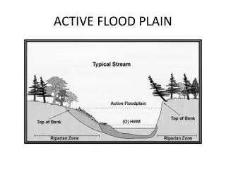
What This Looks Like Detached Garage Community Encroachment Area Line Velocity Zone Source of Flooding Parking Area
Risk Reduction Recommendations • Guide for public and private flood mitigation activities • Analyzes the effectiveness and appropriateness of flood mitigation techniques for eachbuilding
19 Mitigation Techniques • Acquisition and Demolition • Demolition and Rebuild • Acquisition and Relocation • Acquisition, Demolition/ Relocation, and partial Re-sale • Structure Elevation • Abandon Basement and Fill • Full Dry Floodproofing • Full Wet Floodproofing • Audible Flood Warning System • Storm Water Detention Facilities • Storm Water System Control • Automated Flood Notifications • Public Education • Flood Insurance • Levee/Floodwall • Protecting Service Equipment • Partial Dry Floodproofing • Partial Wet Floodproofing • Ring Levee/Wall/Berm
Recommendation Categories • Each mitigation technique is evaluated and placed into one of four categories: Highly Effective, RecommendedThe mitigation technique was determined to be highly effective by exceeding the criteria for the effective category and meeting all of the requirements for this category. This category was developed to identify techniques that were highly effective in reducing risk or have additional community benefit. EffectiveThe mitigation technique was determined to be feasible and effective by exceeding the minimum criteria and meeting all of the criteria for this category. Further Evaluation NeededThe minimum criteria for the mitigation technique is met but further evaluation or additional data is needed to determine if the technique is a viable option. Not RecommendedThe minimum criteria for the mitigation technique is not met. Therefore, the technique is likely not feasible, effective, or may be cost prohibitive.
Flood Mitigation Priority Score • Used to prioritize flood mitigation efforts across the county • Individual properties as well as groups of properties, project areas • Accounts for : • Community-based benefits • Other factors not included in the Flood Risk Property Score
Priority Score Factors • Life and human safety • Cost effectiveness • Proximity to other mitigation projects • Property added to flood zone • Repetitive Loss (RL) structure • Property adjacent to publicly owned land • Property located on five-year planned greenway trail • Property located on five-year planned sanitary sewer route • Property intersects with water quality buffer • Property located in an Environmental Focus Area • Property covered by NFIP policy • Historic preservation and cultural asset protection • Other
Automation Parcels Flood Hazards Buildings (ECs)
Automation • ArcGIS extension
Keys to Success • Quality data • Active involvement from stakeholders • Holistic approach to mitigation • Define “flood risk” for your community • Other important community factors • Capitalize on multi-objective projects to achieve other public benefits • Opportunities to group properties