Download
1 / 16
160 likes | 236 Views
Environmental Impact Statement Workshop EPA Headquarters 20 th June 2003. The R ole of G eology and H ydrogeology in Q uarry D evelopment and I mpact C ontrol Presented by Mark Conroy. Introduction.

E N D
Environmental Impact Statement WorkshopEPA Headquarters 20th June 2003 The Role of Geology and Hydrogeology in Quarry Development and Impact Control Presented by Mark Conroy
Introduction • TES Consulting Engineers provide planning and environmental advice to the quarrying sector. The information contained in this presentation is based on our experience from numerous quarry projects. • Together with water and oil, building aggregates are the most exploited natural resources on earth. • The natural resources extracted by industry include Clay, Sand and Gravel and Rock. • This presentation deals with extraction of material from the surface and does not consider the environmental impacts from underground mining, however some issues are similar.
Introduction – contd. • Output from Irish quarries is estimated to have increased from 6 million to 50 million tonnes per annum in the past 2 decades (Aggregates in Ireland – An Overview, J Sheils). • Existing aggregate reserves are being gradually diminished, therefore additional reserves will be required in the future to meet aims of the National Development Plan and daily construction requirements.
Legislation Governing Control of Quarry Development • Quarry development is currently regulated under the Planning and Development Act 1963 (Part IV), however a significant number of Irish quarries were in operation prior to enactment of this law. • All new quarries and extensions to existing quarries in excess of 5 hectares require an EIA to be carried out under EU Directive 89/337/EC. • Section 261 of the Planning and Development Act 2000 deals with the control of quarries, however this Section has yet to be enacted into law.
Legislation – contd. • Section 261 will be enacted following the publication of guidelines for the quarry industry by the Department of the Environment (awaited). • Section 261 will require all quarries in operation before October 1964 and with planning permission greater than 5 years to register with the relevant Local Authority. • Under Section 261 the Planning Authority in whose functional area the quarry is situated can impose operational conditions or request the operator to apply for planning permission and seek the preparation of an EIS to regulate activities and emissions.
Quarry Design • By its nature the quarrying of aggregates has a major impact on the geological environment. • The EIS should include information relating to the extraction method, the phasing of the extraction and elevations at periods during and at termination of quarrying. • Geotechnical assessment of the quarry design should be included to ensure activities are proposed in a manner to ensure ground stability and no impact on the surrounding environment (i.e. vibration, noise, dust and water run-off).
Geological and Hydrogeological Information to be contained in an EIS • The IGI guidance document “Geology in Environmental Impact Statement” details the main geological aspects that should be addressed in an EIS for quarries (Project Type 18). • The amount of detail included in the EIS is dependent on the nature and extent of the proposal. • Certain critical information should be included and discussed to allow regulators conceptualise the extraction programme and potential impacts and appraise the mitigation measures to ensure the quarrying does not adversely impact the surrounding environment.
Existing Environment – Soils & Geology • Desk study and site specific investigation data to determine the nature, thickness and extent of soil/subsoil and rock within the site, through trial pitting, drilling and geophysics (and other methods). • Assessment of the structural geology • Determination of quality of target mineral, whether clay, sand and gravel or rock (laboratory testing). • Quantification of volumes of unconsolidated material to be removed to access the mineral resources (clay, sand, gravel, or rock). • Quantification of volume of resources/reserves.
Existing Environment – Surface Water & Hydrogeology • Appraisal of surface water drainage pattern. • Characterisation of the groundwater and surface water quality and usage. • Assessment of groundwater vulnerability and depth to watertable. • Determination of catchment area, site piezometry (watertable elevation) and aquifer characteristics (transmissivity and dominant flow regime in the aquifer). • Water Balance Calculations and pump test to determine the zone of contribution.
Potential Impacts – Soils & Geology • Removal of soil and/or bedrock is an unavoidable consequence due to the nature of quarrying activity, however there should be no adverse impacts off-site. • A significant volume of the unconsolidated material removed will be of no economic value and retained on-site. • The quarry design should detail how the removal of material will impact on the surrounding surface topography.
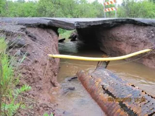
Potential Impacts – Surface Water & Hydrogeology • Extraction of material will increase the vulnerability of the aquifer, reduce evapotranspiration and increase effective rainfall. • Quarrying creates a topographic sump in which water (SW & GW) will accumulate and in most cases will not drain under gravity to natural drainage channels. • If quarrying below the watertable it is desirable to maintain a dry working floor, therefore dewatering will be required. • It will be necessary to pump captured rainwater and groundwater from the floor of the quarry to discharge points from the site. • Water pumped from the quarry floor will be heavily laden with sediment. It will be necessary to settle this water prior to discharge.
Potential Impacts – contd. • Areas sensitive to dewatering (e.g. springs, wetlands and domestic wells) should be identified and protected, which may require changes to the extraction plan. • The aquifer characterisation and hydraulic testing will identify the extent of the catchment area and the Zone of Influence caused by dewatering. • Water balance issues should be addressed to determine how water is managed within the site (i.e. run-off from hardstand areas and exposed rock). • Potential Sources of groundwater and surface water contamination should be identified (fuel storage, dirty water, effluent, etc.)
Mitigation Measures • Unconsolidated material should be beneficially utilised within the site to form landscaped berms to prevent direct views of the quarrying activity. • Excess material could be stockpiled in an appropriate manner in a quarried section for the aftercare measures proposed within the site. • Suitable systems should be designed to treat all water captured within the site to ensure no adverse impacts on the quality of receiving waters (e.g. settlement lagoons and process water recycling infrastructure).
Mitigation Measures – contd. • Appropriate contingency measures should be incorporated to deal with extreme climatic events. • Stormwater retention is required due to the fast response time of rainwater collecting within the quarry. • In general quarries create voids, thereby acting as natural retention ponds, however discharges should be regulated and maintained at a predetermined rate. • The receiving water channels should have adequate assimilation capacity/dilution rate to ensure discharge from quarries do impact on the surface water quality and quantity.
Mitigation Measures – contd. • The environmental code of practice and heath and safety plan for each quarry should ensure that each quarry is operated in a manner to prevent accidents and uncontrolled discharges. • Periodic environmental monitoring will act as a reference to determine the performance of the quarry. The monitoring results should be collated and issued in an Annual Environmental Report. • Quarry operators may need to drill new water wells for households adjacent to quarries if the dewatering is shown to negatively impact supplies.
Interactions • The potential for interactions resulting from quarrying are also very important (loss of ecology and/or archaeology due to soil/subsoil removal; vibration, dust and noise from site activities and blasting; visual impacts due to changes in topography, nuisances from wind swept dust, human dissatisfaction with quarrying activities). • The EIS check for the possibility of quarrying interacting with pSACs/pNHAs and of course GHAs (Geological Heritage Areas.