Download
1 / 47
470 likes | 640 Views
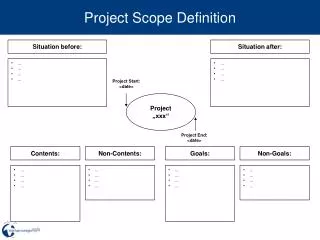
Project Scope. Cultural Resource Assessment Right of Way Mapping Public Involvement Quantities Long Range Estimates Specifications Quality Deliverables Constructable /Biddable Deliverables Electronic Deliverables Schedule Control. Photogrammetry Survey Geotechnical Roadway Design

E N D
Project Scope • Cultural Resource Assessment • Right of Way Mapping • Public Involvement • Quantities • Long Range Estimates • Specifications • Quality Deliverables • Constructable/Biddable Deliverables • Electronic Deliverables • Schedule Control Photogrammetry Survey Geotechnical Roadway Design Drainage Design Permitting Pavement Design Traffic Control Plans Lighting Justification SUE Utility Coordination Support Contamination Assessment
PD&E Study • Commitments • Eastern Indigo Snake Protective Measures • Bald Eagle Nest Survey Prior to Construction • Gopher Tortoise Survey Prior to Construction • Re-Initiate Section 7 Florida Panther Consultation • Mitigate Net Loss of Wetlands for Wood Stork • Continuation of Public Involvement Process
Project Issues Typical Section Pond Location Historic Drainage Pattern Wetland Impacts Floodplain Impacts Threatened & Endangered Species Permitting Requirements Access Management
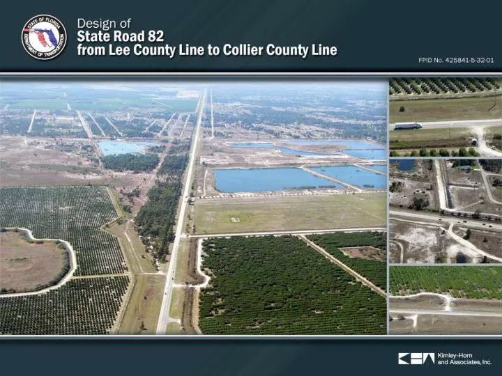
Project Description • Posted Speed = 60 MPH • Existing Horizontal Geometry • No Horizontal Curves • Two Deflection Points • Land Usage • North Side • Mining Facility • Rural Agricultural Land • South Side • Mining Facility • Residential Property • Project Location and Limits • From the Lee/Hendry County Line to the Hendry/Collier County Line • Roadway Classification • Rural Minor Arterial • Emerging SIS Facility • Hurricane Evacuation Route • Existing Typical Roadway Section • Two-Lane Rural • Open Ditch Drainage • 200-foot Right-of-Way
Design Speed • PPM Maximum for 6-Lane High Speed Suburban – 50 MPH (PPM, Vol. I, Section 2.16.1) • PD&E Study – 55 MPH (Approved Ultimate Typical Section) • Scope of Services – 55 MPH (Interim Typical Section) • Posted Speed – 60 MPH • Operating Speed > 60 MPH • Recommended Design Speed = 55 MPH • Consistent with Adjacent Projects
Proposed Interim Typical Section • Expandable to the Ultimate PD&E Recommended Six-Lane Typical Section • Includes Multi-Use Path • Elevated Sidewalk and Path • Reduced Outside Shoulder Width (Cost Savings) • Optimized Swale Size (Cost Savings) • Typical Section Meets Scope Four-Lane Divided
Proposed Interim Typical Section • Expandable to the Ultimate PD&E Recommended Six-Lane Typical Section • Includes Multi-Use Path • Elevated Sidewalk and Path • Reduced Outside Shoulder Width (Cost Savings) • Optimized Swale Size (Cost Savings) • Typical Section Meets Scope Four-Lane Divided
Outside Shoulder Reduce Outside Shoulder Width to Eight-feet Provides Added Width for Harmonization & Multi-Use Path Reduces Stabilization Cost
Interim Typical Section Benefits Provides for Three-Feet Base Clearance Accommodates Multi-Use Path Accommodates Off-Site Drainage Reduce Construction Cost – Cost Savings Reduces Right-of-Way Acquisition – Cost Savings
End of Project Transitions End Project FPID 425841-5 660’ 1485’ • Objectives • Construct Full Width of Pavement • Construct Necessary Drainage Elements • Optimizes Future Construction in Collier County
Pavement Design Considerations • Pavement Type Selection Report • Pavement Design • Use FC-5 • Base Clearance Variation • Resilient Modulus Reduction • Elevated Estimated Seasonal High Groundwater
Drainage & Permitting Attenuate and Maintain Historical Flows Patterns and Outfalls Maintain Hydro Periods of Viable Wetlands FDEP Basin Assessment Water Quality and DEP Nutrient load Management Pond Design Floodplain Impactsand compensation Manage Offsite Drainage Culvert Extension Electronic Permitting
Drainage & Permitting Attenuate and Maintain Historical Flow Patterns and Outfalls Issues No apparent basin outfall Undefined ditch grades Flat grades, high water table No distinct historical flow directions Design Solutions Design Storm Management System as a Closed basin Partially replace ditch on south Utilize SFWMD credits for systems with inlets in grassed areas (Interceptor swales) Prevent concentrated Post Development Pond Point Discharges Slow Recovery of Detention Volume back into the R/W
Drainage & Permitting Maintain Hydro Periods of Wetlands Issue Prevent alteration of hydrology to adjacent wetlands Secondary Impacts and buffer zones Design Solutions Eliminate deep offsite collector ditches along wetlands Maintain 25ft buffer beyond construction limits where feasible to minimize secondary impacts Use Ordinary High Water (OHW) for Surface water limits impacts instead of top of bank
Drainage & Permitting WBID 3259 X FDEP Basin Assessment Issues R/W Needs Critical FDEP Classification TMDL Status Nutrient Loading Calculations Coocolahatshee and Everglades “South” West Coast watershed WBID 3259X
Drainage & Permitting • Water Quality and DEP Nutrient load Management Issues • FDEP Statewide Storm water Rule • SFWMD interpretation and application of the rule • Wet detention water quality standards Design Solutions • Statewide Storm water rule is not adapted but is currently enforced in various water management districts. Conformance with the rule will be demonstrated in the Pond design using the District one Event Mean Concentration (EMC) values below Wet detention Total Phosphorus removal Wet detention Total Nitrogen removal.
Drainage & Permitting • Design solutions • Evaluate dilution with offsite runoff to reduce Post-development Nitrogen removal efficiency and reduce the need for a expensive treatment train design • Utilize various treatment credits (Natural conservation area, site reforestation, Florida Friendly landscaping, etc. • Increase nutrient removal, by increasing permanent pool volume and resident time • Select Treatment volume (TV) depth based on available hydraulic head • Pond Design
Drainage & Permitting • Design solutions • SR 82 is a designated hurricane evacuation route and will need to provide flood free access (Travel lanes above the BFE) • We will assess and discuss the need for an expensive compensation site with SFWMD, given the vast size of the floodplain, relative small impact and insignificance of the rise • The rise calculates +/- 0.006 feet or 0.072 inches in a highly undeveloped rural area • Floodplain Impacts and compensation
Drainage & Permitting Culvert Extension Issue Only cross culvert (double 30”RCP) in the project area was extended around 2004. Flow line elevation appears to be higher than the adjacent ditch and impedes positive drainage. Solution The structural condition, historical and future function within the basin will be assessed during final design and evaluated for extension or replacement.
Permitting Requirements and Coordination • Understand District One Electronic Permit Preference • Environmental Resource Permit (SFWMD) • Section 404 Dredge & Fill Permit (USACE) • NPDES (FDEP) • Coordinate with USFWS (Florida panther) • FWC Gopher Tortoise Relocation Permit prior to Construction (unlikely)
Wetlands • Mainline (within 200 ft of existing roadway) • Approximately 8 acres of wetlands and 4 acres of surface waters • Surface waters are unlikely USACE jurisdictional • Pond Sites • No additional impacts anticipated • Mitigation • Wetland mitigation available at Panther Island, Big Cypress, and Corkscrew Regional (send out for competitive bid process) • Senate Bill (not preferred option)
Protected Species Florida Panther • PD&E commitment - re-initiate USFWS Section 7 Consultation • Entire project within the secondary zone • Habitat analysis required for any proposed impacts for new ROW and/or SMF and FPC sites • Biological Assessment Anticipated • Panther mortality approx. 1.5 miles southeast of project on Corkscrew Rd in 2010 • Project limits do not meet criteria for wildlife crossings • Mitigation for impacts available at PIMB, BCMB, and CRMB
Protected Species Crested Caracara • PD&E stated MANLAA, therefore, no further coordination anticipated Wood stork • Within the CFA of three wood stork colonies • Foraging Analysis required if impacts to surface waters and wetlands are greater than 5 acres combined Bald Eagle • Nearest nest is greater than 5 miles to southeast • Will survey appropriate nesting habitat prior to document submittal Eastern Indigo Snake • Standard FDOT Construction Precautions Gopher Tortoise • Suboptimal habitat • Survey appropriate habitat
Traffic Control Plan Phase I
Traffic Control Plan Phase II
Traffic Control Plan Phase III
Utility Coordination Support Support District One Prepare utility conflict matrix Attend Utility Conference Present plans
Geotech Considerations Establish ESHW Cap Rock Confirm sub-surface condition
Noise Single isolated residence Noise barrier not reasonable abatement Re-evaluate during design
LRE Review Element FDOT LRE KHA LRE $1,529,400 $1,265,700 Median Component – Type E Curb $144,200 $0 Total Difference $407,900 10% Roadway Pavement Width
Unique ConceptsCost Savings • $ 11,000 • $ 150,000 • $ 20,000 $ 191,000 5% Reduce Shoulder Width Eliminate Floodplain Comp Site Demonstrate No Impaired Water Body Total Cost Savings
Project Schedule Will provide defined schedule 10 days after NTP R/W Mapping – 18 Months Design Schedule – 20 Months
Quality Control KHA QA/QC Manual All Documents Seasoned staff Subconsultants required to follow Peer/Constructability Review
Reasons for Selecting KHA Thorough understanding of project issues Experience to develop and implement cost savings solutions Staff is available to start immediately Complete understanding of District One Preferences Extensive experience with District One staff
Awareness of District Procedures Plans/Reports Submittal Process Electronic Review Comments Meeting Protocol E-mail Subject Line Invoicing Procedures SUE All Sign Posts De-Silting and Video Inspection of all Cross Drains Projection of Plans for Utility Meeting