Download
1 / 18
180 likes | 320 Views
The FGDC US Cadastral Standard ( CadNSDI ). October 31, 2013 Nancy von Meyer nancy@fairview-industries.com Meet Up Presentation. Agenda. CadNSDI Standard Background, Terms and Scope The Standard PLSS Data PLSS - Feature Classes and Examples Standard PLSS data in the Fabric

E N D
The FGDC US Cadastral Standard (CadNSDI) October 31, 2013 Nancy von Meyer nancy@fairview-industries.com Meet Up Presentation
Agenda • CadNSDI Standard Background, Terms and Scope • The Standard PLSS Data PLSS - Feature Classes and Examples • Standard PLSS data in the Fabric Questions – ask in the chat box at any time If you hear a dog – It’s mine and it’s this one ---
Development of the PLSS Standard • Content Standard adopted by FGDC 1995 (one of the first FGDC Data Standards) • Need for standard physical format - WGA Cadastral Forum 2000 • Implementation Templates and Guidelines – Cadastral Subcommittee - 2004 • Geocommunicator - 2005 • Business Need for seamless standardized PLSS – Cadastral Subcommittee 2006-2008 • Standardized statewide PLSS from GCDB – started in 2006 • BLM adoption of template and guideline – 2009 • BLM and Cadastral Subcommittee Publication standard Version 2 adopted - 2012
Terms and Concepts • CADNSDI – This is the cadastral component of the National Spatial Data Infrastructure and it includes core parcel data and cadastral reference data, most commonly the PLSS. • PLSS CadNSDI– standardized PLSS data in the Cad NSDI Format • Production and Publication – Publication data are the operation and maintenance data sets, such as GMM, and include operations like adding new survey control and incorporating new field observations. Publication data are distribution and dissemination data sets that are made available for customers and business applications.
Background documents on all these concepts – http://www.nationalcad.org, look under the PLSS Work Group on the Projects List.
A brief history and basic concepts and terms describing the components of the PLSS can be found in the national atlas http://www.nationalatlas.gov/articles/boundaries/a_plss.html
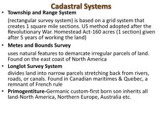
PLSS Development • Ideally – All of the land would have been surveyed first, and then settled. • Actually – There are many situations where settlement, land title, or claims pre-dated the surveys. • So …PLSS States are not really simpler than non-PLSS States, they just have an added survey system in addition to all of the other settlement and survey patterns found in the US.
PLSS Lotting • There are two cases that create lotting in the PLSS – Segregation and Survey Correction. • Survey Correction means to define areas that are not “nominally” regular aliquot parts, typically due to survey and geometry corrections (the Earth is round issues). • Segregation means to separate out a special survey from the Rectangular Survey and to account for all of the irregular lands.
Metadata at a Glance This feature Class illustrates the data Steward for the Cadastral Reference Data. It also tracks Currency (Vintage) last update. It starts with the Townships as the unit of measure but this will evolve as data stewards assume responsibility for the Cadastral Reference
Data Stewards • Data Stewards provide the most current Cadastral Reference Data in a standardized form. • Data Stewards contribute their updates to a statewide “Community Data Set” that can be publicly consumed. • Data Stewards work with each other to define and maintain seamless boundaries among data stewardship areas. • On federally managed lands, regardless of location, the BLM is responsible for the PLSS and mapping and description of the rights and interests in the land. • Onshore, the BLM administers all mineral lands as well. • On non-Federal Lands the Data Steward may be a county or the state or other identified entity. • The extent of Federal Lands is described by a national data set called Surface Management Agency (SMA).
http://nationalcad.org/projects/cadastral-data-standards-and-guidelines/http://nationalcad.org/projects/cadastral-data-standards-and-guidelines/
Where to get the Data The most authoritative data PLSS CadNSDI data will be available thru either state or BLM Office portals since these portals have a “gate keeper” and are not crowd sourced. Some of this data is available now others will be soon. The web links may change and there will be more but these are a start. Organized by NCAA Football Communities the links are: Big Ten Ohio - http://www.ohiodnr.com/tabid/15402/Default.aspx Michigan - http://www.michigan.gov/cgi/0,4548,7-158-52927_53037_12693---,00.html Indiana - http://www.indianamap.org/resources.php Wisconsin - http://www.sco.wisc.edu/ Minnesota - http://www.mngeo.state.mn.us/chouse/metalong.html SEC and ACC Arkansas - http://www.geostor.arkansas.gov/G6/Home.html Mississippi - http://gis.ms.gov/portal/default.html Alabama - http://gis.alabama.gov/ Florida - http://www.fgdl.org/download/ Pac 12 and Mountain West Utah - http://gis.utah.gov/data/Montana - http://nris.mt.gov/gis/ BLM State Offices