Download
1 / 24
240 likes | 300 Views
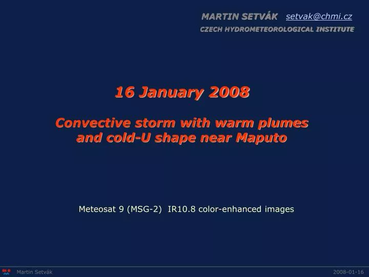
MARTIN SETVÁK setvak@chmi.cz. CZECH HYDROMETEOROLOGICAL INSTITUTE. 16 January 2008 Convective storm with warm plumes and cold-U shape near Maputo. Meteosat 9 (MSG-2) IR10.8 color-enhanced images. Martin Setvák. 2008-01-16.

E N D
MARTIN SETVÁKsetvak@chmi.cz CZECH HYDROMETEOROLOGICAL INSTITUTE 16 January 2008 Convective storm with warm plumes and cold-U shape near Maputo Meteosat 9 (MSG-2) IR10.8 color-enhanced images Martin Setvák 2008-01-16
Here starts the storm cell which later on forms the warm plume and the cold-U shape This cold overshooting top generates in the next image a warm spot Martin Setvák 2008-01-16
First of the cold overshooting top and adjacent warm spot couplets; this warm spot evolves in next images into a larger warm area Martin Setvák 2008-01-16
This short-lived cold overshooting top does not produce a warm spot Martin Setvák 2008-01-16
Martin Setvák 2008-01-16
In this area begins a formation of several couplets of cold overshooting tops and related warm spots (forming on their downwind side); the individual warm spots merge later into a larger warm area. Martin Setvák 2008-01-16
This is the cell that probably later on forms the warm plume and cold-U shape; here we see a nice example of cold overshooting top and warm spot couplet. The individual cold overshooting tops keep forming in next images approximately in the same area, the cell becomes a dominant one from about 15:45, which might indicate a possible supercellular nature of this storm cell. Martin Setvák 2008-01-16
Martin Setvák 2008-01-16
Martin Setvák 2008-01-16
Martin Setvák 2008-01-16
From now-on, this cell becomes the dominant one in the area ... at least based on MSG imagery. Martin Setvák 2008-01-16
Martin Setvák 2008-01-16
Martin Setvák 2008-01-16
Martin Setvák 2008-01-16
Martin Setvák 2008-01-16
Here the individual warm spots start merging into a feature, which begins to resemble a warm plume. The follow-up plume can be traced next till about 18:45 UTC, contributing to the cold-U appearance of the storm. Martin Setvák 2008-01-16
Martin Setvák 2008-01-16
Martin Setvák 2008-01-16
Martin Setvák 2008-01-16
Here the warm plume is best developed, despite the fact that the cold overshooting tops have already weakened (based on IR imagery). The plume can be followed next till about 18:30 – 18:45, when it weakens and dissipates. The cold-U feature can be traced till about 18:45 UTC. Martin Setvák 2008-01-16
Martin Setvák 2008-01-16
Martin Setvák 2008-01-16
Martin Setvák 2008-01-16
Martin Setvák 2008-01-16