Download
1 / 18
180 likes | 314 Views
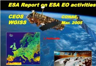
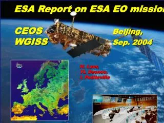
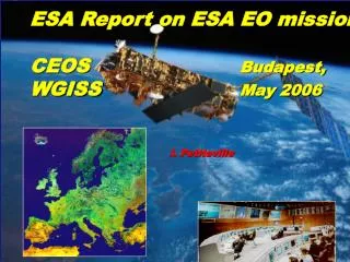
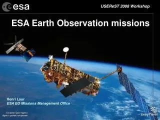
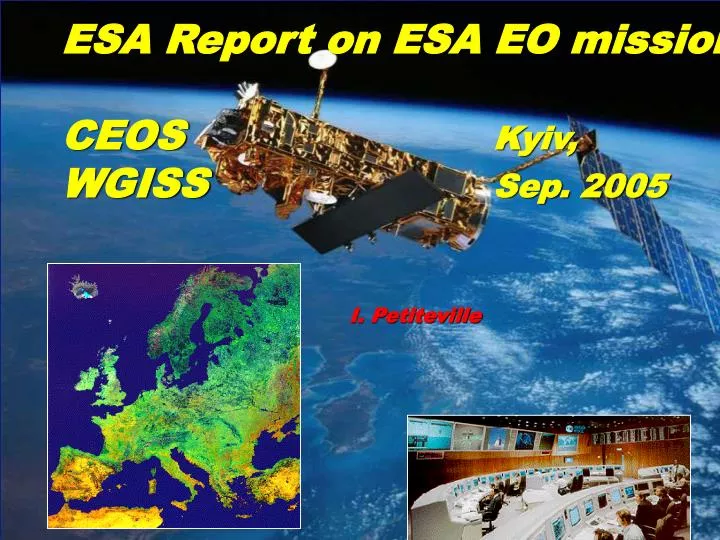
ESA Report on ESA EO missions CEOS Kyiv, WGISS Sep. 2005 I. Petiteville. Topics. Hurricane Katrina Earth Explorer Missions 3 rd Party missions: ALOS. New Orleans, Aug. 31, 2005 . ENVISAT ASAR image The circular area of the New Orleans Superdome,

E N D
ESA Report on ESA EO missions CEOS Kyiv, WGISS Sep. 2005 I. Petiteville
Topics Hurricane Katrina Earth Explorer Missions 3rd Party missions: ALOS
New Orleans, Aug. 31, 2005 . ENVISAT ASAR image The circular area of the New Orleans Superdome, is barely visible to the northwest of the double span of the Greater New Orleans Bridge, across the Mississippi from the Algiers Point Revetment at the first bend of the river at the right edge of the image. Water was waist-high in the area when this image was acquired. The area west of City Park, the dark area at centre image just east of the I-10 Bridge bordering on the Orleans Outfall Canal, also appears to be heavily flooded. Both airports were also under water. • Envisat Advanced Synthetic Aperture Radar (ASAR) radar image. • New Orleans, Aug. 31, 2005. • Image Mode Precision (30 meter resolution)
Envisat Advanced Synthetic Aperture Radar (ASAR) radar image. • New Orleans, Sep. 6, 2005. • Image Mode Precision (30 meter resolution)
PROBA CHRIS 3-bands colour composite • New Orleans, Sep. 3, 2005 • Dark brown areas = probable flooded areas and to cloud shadows. • Space resolution at Nadir 18m • Swath size about 14km. • "Processing by Sira Technology Ltd, UK, 2005."
EARTH EXPLORERS goce cryosat smos adm
Earth Explorer Missions Core missions: GOCE:Gravity and Ocean Circulation. ADM-Aeolus: Measuring the winds at all altitudes. Opportunity missions CRYOSAT: Sea-Ice Monitoring Floating sea ice NOAA SMOS: Soil Moisture and Ocean Salinity. Salinity in the Mediterranean
Earth Explorer missions (1/3) • CRYOSAT: • Launch on October 8, 2005 at 15:02 (UTC) from Plesetsk (Russia). Launcher: Rockot vehicle, based on the SS-19 intercontinental ballistic missile • Recently commercialised, Rockot has already launched several satellites and the SS-19 has had over 150 test firings.
Part of the 60 tonne CryoSat convoy being transported to the Antonov aircraft for loading (Munich airport) • Credits: EADS Astrium
CryoSat arrived at the Plesetsk Cosmodrome on 1 Sep. 2005, where it was unloaded from the Antonov into the Integration Facility hall. • Credits: ESA
CRYOSAT Ground Station Kiruna Salmijarvi CRYOSAT equipment
Earth Explorer missions (2/3) • ADM Aeolus: • GS PDS development KO in Jul. 2005, • PDS completed in 2007. • Launch in Oct. 2007. • SMOS: • Ground Segment Phase C/D just starting
Earth Explorer missions (3/3) • GOCE: • Ground Segment kick-off in Sep. 2003 • Launch end of 2006
ALOS • 3 sensors: 1 SAR L-band and 2 optical • ALOS Data European Node (ADEN): • GS development kicked-off end of July 2002. • Factory Acceptance Tests completed • Launch delayed (beginning of 2006. TBC by JAXA)