Download
1 / 41
410 likes | 517 Views
NASIS 6.1 and WSS 2.3 Updates. Jim Fortner National Soil Survey Center April 20, 2011. NASIS 6.1 Release. NASIS 6.1 came online – April 12 Also released – Updated SDV Rule Manager Updated SC/OSD Maintenance tool. NASIS 6.1 Features. Improved editing performance ~ 50 bugs fixed

E N D
NASIS 6.1 and WSS 2.3 Updates Jim Fortner National Soil Survey Center April 20, 2011
NASIS 6.1 Release • NASIS 6.1 came online – April 12 • Also released – • Updated SDV Rule Manager • Updated SC/OSD Maintenance tool
NASIS 6.1 Features • Improved editing performance • ~ 50 bugs fixed • Data tables and columns for RaCA & DSP data • Excel spreadsheet imports • VNIR scan file imports • Run national reports in background • View reports, queries, etc. in grid • New drop down selection of child tables • Run multiple validations or calculations at once
Import Requirements • Worksheet mapping file has to be created by NSSC for each worksheet of each version of a workbook. • Currently have these for RaCA versions 2.07 thru 2.14, and new 2.15 • DSP workbook being developed
RaCA import rules (& DSP) • For RaCA & DSP, the import process APPENDS to existing Site and Pedon records. • Corresponding Site, Site Assoc., & Pedon records MUST already be in NASIS.
RaCA import rules (& DSP) • These MUST be checked out for the spreadsheet to import. • User Site ID, User Pedon ID, Site Obs. Date, & horizon designation MUST agree between NASIS and spreadsheet. • Multiple spreadsheets can be imported at once.
Local Plant Issue • Plant symbols and names on the spreadsheets MUST already be in the Local Plants table in NASIS • Symbols and names MUST match EXACTLY! • Any mismatch will abort the import
VNIR Scan file import • VNIR scan filename MUST match that recorded on the spreadsheet • If file(s) are stored in same directory as the spreadsheet, they are automatically imported with the spreadsheet file
VNIR Scan file import • Files can also be imported from NASIS Pedon Horizon VNIR Scan table • Click in VNIR File Name column • Click Open button • Browse for desired file
Run National Reports Offline • Avoids 10 minute timeout limit • Could still hit memory limit
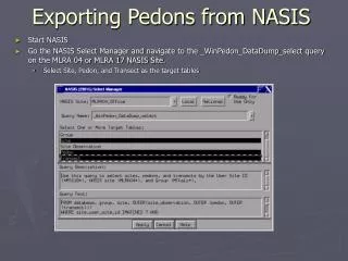
Reports, queries, etc. in grid • Run appropriate query to bring desired objects into your Selected Set • View the appropriate table. • Allows for • checking out/in a group of records at once • changing ownership of multiple records. • Cannot edit the script in this mode; must open in normal tab mode.
Reports, queries, etc. in grid Clicking in this column will open the report in normal tab mode.
Run Multiple Validations • Works for calculations too
SDV Rule Manager • New URL https://sdvrulemanager.sc.egov.usda.gov/RuleManager.aspx
SDV Rule Manager • Changes to reflect how rules are stored in NASIS 6.0 data structure
WSS 2.3 Status • Currently in QA testing • Release date – end of May/early June
WSS 2.3 New Features • Import/export AOI boundary file • Bookmark the AOI • Imbed location and/or AOI coordinates in URL • Quick navigation in US territories • New Lat/Long entry options
Import AOI Boundary file • Can be from • file previously exported from WSS • File created using ArcGIS or other software • Shapefile format • .shp and .prj files needed • <10,000 acres; < 90 points; <100 Mb
Future - NASIS • Point data model changes - SSO lab data • Update Pedon PC to match • Move mustatus and farmland class to legend mapunit • Add mapunit history and text tables to Legend Mapunit • Customizable choice lists
Future – NASIS – cont’d • Consider changing way data is downloaded from national to local database • Local db management options • Store images and document files • Adjustable font sizes
Future – WSS / SDM • Rebuilding backend operations • Moving from ESRI tools to SQL Server tools • Use Bing imagery • Increase allowable AOI limit - >100k ? • Combine functions of SDW application into WSS – reports and downloads • Add new data elements from NASIS to SDM database – available to WSS
Future – WSS / SDM – cont’d • Handle line and point map units • Change SDM to WGS 84 – accommodates PIA data • Display additional ESD content • Add in BIA land areas for quick navigation