Download
1 / 14
140 likes | 258 Views
Oceanic Convection Diagnosis and Nowcasting. Cathy Kessinger, Cindy Mueller, Huaqing Cai, Gary Blackburn, Nancy Rehak, Kay Levesque, Ben Hendrickson, Steve Carson, Dan Megenhardt. ICMCS-V Conference - October 31, 2006. Oceanic Convection Diagnosis and Nowcasting.

E N D
Oceanic Convection Diagnosis and Nowcasting Cathy Kessinger, Cindy Mueller, Huaqing Cai, Gary Blackburn, Nancy Rehak, Kay Levesque, Ben Hendrickson, Steve Carson, Dan Megenhardt ICMCS-V Conference - October 31, 2006
Oceanic Convection Diagnosis and Nowcasting • Federal Aviation Administration (FAA) and National Aeronautics and Space Administration (NASA) sponsors • Oceanic aviation community • Collaboration with Naval Research Laboratory and Massachusetts Institute of Technology Lincoln Laboratory • Developing oceanic diagnosis and nowcasting products • Few derived products available for oceanic aviation • Convective Diagnosis Oceanic (CDO) • GOES-based detection of convection • Fuzzy logic combination of 3 algorithms: • CTOP: NRL Cloud top height • CldClass: NRL Cloud classification • GCD: Global Convective Diagnosis • Convective Nowcast Oceanic (CNO) • Extrapolation of CDO using an object tracker • 0-2 hour nowcasts now; longer term nowcasts/forecasts later • Gulf of Mexico domain - extend to Pacific domain soon
NRL Cloud Top Height (CTOP) • Cloud IR temperature converted to heights • Global Forecast System (GFS) model sounding • Temperature matched to pressure level • Pressure level converted to height via Standard Atmosphere • Works best with opaque clouds
NRL Cloud Classification (CldClass) • Discriminates cloud types • Compares derived fields from current image to those “truthed” by experts to get best match • Daytime and nighttime versions combined • Nighttime less precise due to loss of visible channel Daytime: 15 Categories Nighttime: 10 Categories
Global Convective Diagnostic (GCD) • Uses channel differencing (gvar_ch3 - gvar_ch4) • Differences near zero are significant • Indicates updraft region
INPUT CTOP CloudClass GCD FUZZY LOGIC ENGINE w Apply Threshold w Swf Convective Diagnosis Oceanic w w Apply membership functions Apply weights Compute Interest Field T Fuzzy logic methodology • Inputs are scaled between 0-1 • Weighted summation calculated • Threshold applied to define CDO
1 1 CTOP GCD 0 0 0 20 40 80 (Kft) -10 -5 -1 25 30 (delta BTemperature) 1 CldClass Daytime CldClass Nighttime 0.5 0 Missing Clear Snow Cumulus Open Mixed Clouds Deep Convection Thick, High Thin, High Middle Cum. Congestus Low Missing Sun Glint Clear Cumulonimbus Cirrus Anvil Cum. Congestus Cirrostratus Cirrocumulus Cirrus Altostratus Altocumulus Cumulus Stratocumulus Stratus CDO Membership Functions Weight = 1 Weight = 1 Future: Add number of lightning strikes as a feature field and specialized POES fields Weight = 2
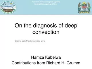
CDO Gulf of Mexico from 4 June 2006 at 2215 UTC Visible & IR CTOP CDO GCD Cloud Classifier
Gulf of Mexico from 4 June 2006 at 2215 UTC Visible & IR CDO with threshold applied
Convective Nowcast Oceanic (CNO) • Methodology: • Extrapolate the CDO • TITAN – object tracker for storm motion vector • Use Global Forecast System (GFS) model • Frontal likelihood and stability analysis (from NCWF2,6) • Additional fields to be added (work in progress) • Sea surface temperature • Warm water = deep storms; Cold water = no/shallow storms • QuikSCAT scatterometer near-surface winds • Updated twice/day and shows near-surface convergence • Sounder: Temperature/moisture vertical profiles • Stability analysis • TRMM lightning climatology • Merge satellite-tracked winds with GFS to improve wind field • Returns mesocale features • TRMM PR and CloudSat CR to verify storms • Collecting the necessary pieces ; now put them together
QuikScat Divergence CNO Work in Progress • Polar orbiter data: • Sea surface temperature • QuikScat winds • Near-sfc convergence SST Cloud Top Height
Nowcast Design Concept TRMM Lightning Climatology • Growth • SST > 26 deg C • QuikSCAT near-surface convergence • Unstable/neutral conditions • Sounder • GFS CDO-detect CTOP CClass GCD Ltg Vis IR CDO-extrap (GFS winds + sat-tracked winds) Object Tracker for Storms Used to modify storm shapes • Decay • SST < 26 deg C • No QuikSCAT near-sfc convergence • Stable conditions • Sounder • GFS TRMM Verification
IR 1hr CNO Verification IR 2hr CNO Verification Visible IR 1hr CNO 2hr CNO Summary • Methodology for the Convective Diagnosis Oceanic • Design for 0-2 hr Oceanic Nowcasting • Preliminary results shown below for 1 hr and 2 hr Thank you!